Climate Change in the Red Deer River Basin
Characteristics of the Red Deer River Basin
Spanning 49,000 square kilometres and occupying eight percent of Alberta, the Red Deer River Basin is the largest sub-basin of the South Saskatchewan River Basin. It extends through multiple Natural Regions, including the Rocky Mountains and the Parkland in the west, and the Grassland in the east.
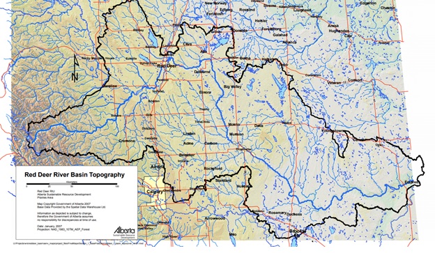
Image source: Red Deer River Watershed Alliance1.
The Rocky Mountain Region is characterized by forests and high-elevation mountain peaks. Although this region makes up a small portion of the area of the Red Deer River Basin, it is important for the water in the river. This region has the highest precipitation, and because the mountains are steep, runoff and snow melt travels quickly down the tributary streams and into the Red Deer River.
The Parkland Region has more moisture than the Grassland Region to the east, and is characterized by rolling hills and stands of aspen trees. This geography alongside the wetter climate results in the formation of many small streams and wetlands.
The Grassland Region is characterized by hot dry summers and cold harsh winters. Annual precipitation levels are low (300 to 400 millimeters per year), meaning there is not enough water to support forests or year-round wetlands.
In part due to the contrast in climate between the dry Grassland and wetter Parkland areas of the Basin, the Red Deer River is often viewed as the border between the dry south of Alberta and the wetter northern climates.
The region is sparsely populated, with a density of five people per square kilometre. It includes all or parts of 57 urban municipalities, 17 rural or regional municipalities and one First Nation2. Major communities in the Basin include Sundre, Red Deer and Drumheller. Primary commercial activities include industrial processing plants, agriculture and resource extraction.
Climate of the Red Deer River Basin
Because the Red Deer River Basin is situated between the warmer and drier climate of southern Alberta and the generally cooler and wetter climate of northern Alberta, average temperatures and precipitation are variable. The impacts of climate change may also be somewhat different depending on the location in the Basin.
To determine the climate of a given area, scientists compile data from instruments such as thermometers, stream gauges, and precipitation gauges to track the weather. As can be seen in the instrument record, the average amount of precipitation in the Red Deer River Basin varies by region, ranging from around 500 millimeters per year to around 300 millimeters per year. The average maximum daily summer temperature is about 23 degrees Celsius, and the average maximum daily winter temperature is about -2. The data are from the instrument record compiled by Environment Canada.
Impacts of climate change on water
Like everywhere else in Alberta, the Red Deer River Basin is projected to experience warmer air temperatures in the coming decades. Because of this warming, modelling studies suggest that the winter snowpack in the Basin will melt earlier in the year. One study estimated that snow melt could occur two weeks earlier3, and another projected 10 to 38 days earlier.4 This early melt may result in high river flows before the water is needed or when river managers are not ready for it, leading to flooding. If the snow melts earlier, this may also leave less flow in the river later in the summer during hot, dry periods when water is needed most.
Additional models project that the Red Deer River Basin will get more annual precipitation on average than it currently receives.5 However, the increasing air temperatures will likely cause more evaporation from reservoirs and lakes, and plants will need more water because of higher rates of transpiration.6
Finally, the models show that the single lowest annual flow year and the single wettest annual flow year could occur within the same 30-year timeframe. This projection highlights the increased variability that may be experienced in the region.7
Sharing water in the Red Deer River Basin
Because of the changing climate in the Red Deer River Basin, snow could melt earlier in the year, with potentially higher spring flows and lower summer, fall, and winter flows. These changes could impact the daily lives of people working and living in the region. A few examples of impacts include:
- Increased floods and droughts.
- Crop failures due to water shortages in the late summer or due to extreme weather like heavy rain, snow, or hail.
- Changes to recreational opportunities such as fishing and rafting that rely on expected water levels and flow rates.
The wild animals and plants may need more water in warmer temperatures, and aquatic ecosystems may be impacted by changing stream flow. For example, fish that rely on higher river levels to spawn in the fall may face challenges, and species that need cold water may not thrive in warming creeks. Warm-water adapted species may become more common.
Significant population and economic growth may also impact the Basin, both of which will require more water. More people will increase municipal water demands. Economic growth will also increase demands on food production because more people will require more food. Water demands for irrigation are projected to increase. The Red Deer River Basin is also seeing an increase in oil and gas development which is very water intensive. These demands may lead to shortages of water under any future climate forecast.
Water for the future and how you can contribute
Ensuring there is enough water for all users in the Red Deer River Basin in the future will require balancing demands with the water available. In the Basin, agriculture, oil and gas, and population growth may play a bigger role in future water availability than climate change.
In the event of a high population growth scenario, water conservation will be key to ensuring there is enough water available. In a report written about water management in the South Saskatchewan River Basin, current agricultural practices have resulted in irrigated water reductions of 5% in winter and 15% in summer8. In the future, industry, municipalities and agriculture will need to implement new technologies and best practices to further minimise water usage.
In the event of a high growth scenario, climate scientists also recommend that additional water storage such as reservoirs be built along the Red Deer River to ensure water availability in drier periods. However, building dams to create storage reservoirs can have significant impacts on the aquatic environment including stopping fish migration, changing river flow patterns, increasing water temperatures, and capturing sediment and nutrients that downstream plants and ecosystems need. When planning storage reservoirs, care must be taken to minimise environmental impacts, including potentially building reservoirs off stream (near the river but not right in its path).
Sources
- Red Deer River Watershed Alliance. (2021). Water Connects Us All. Retrieved from https://rdrwa.ca/
- Alberta Environment. (2007). Current and Future Water Use in Alberta – Red Deer River Basin. Retrieved from https://albertawater.com/docs-work/projects-and-research/dynamics-of-albertas-water-supply/20-chapte-r7-red-deer/file
- Climatic Change. (2012). Potential Impact of Climate Change on the Water Availability of South Saskatchewan River Basin. Retrieved from https://link.springer.com/article/10.1007/s10584-011-0221-7
- Alberta WaterSMART. (2015). Climate Vulnerability and Sustainable Water Management in the SSRB Project: Red Deer River Basin Modelling, Final Report. Retrieved from http://albertawater.com/.
- Journal of the American Water Resources Association. (2018). Projecting Canadian Prairie Runoff for 2041-2070 with North American Regional Climate Change Assessment Program (NARCCAP) Data. Retrieved from https://onlinelibrary.wiley.com/doi/abs/10.1111/1752-1688.12642
- Ibid, 2018
- Ibid, 2015
- Ibid, 2015