Climate Change across the Canadian Prairies
Water availability on the Canadian Prairies
The Canadian Prairies stretch across the southern half of the three provinces of Alberta, Saskatchewan and Manitoba. The Prairie region comprises several major basins, or watersheds, including the Saskatchewan River, the Missouri River, the Assiniboine River, and the Lake Winnipeg Basin.
This region is diverse, containing large urban and agricultural areas, forests, and National Parks, each of which is impacted by the amount of available water. Specifically, water availability impacts the region in terms of economic, social and environmental stressors.
In the Prairies, future changes in climate, how we use the land, and our growing population will also cause stresses to water availability.
As a result of each of these factors, it is essential that we understand how water availability on the Prairies is projected to change. This understanding will help ensure our water security (meaning that we will have enough water supply to meet demands) because we will be able to effectively plan for the future changes and challenges we may face.
Projected changes to precipitation across the Prairies
In 2019, WaterSMART Solutions Ltd. conducted a project that included a high-level analysis of how climate change will impact water availability in the Prairie watersheds. A summary of the work and a copy of the report can be requested through this link. The project relied on a number of different climate model results that were combined and averaged. The figures in the sections below highlight the key findings of the project.
Water Supply in the Prairies
Before learning how climate change may impact the Prairie water supply, it is important to understand where water on the Prairies originates. The map figure below shows the annual amount of precipitation flowing to the main river in each region.
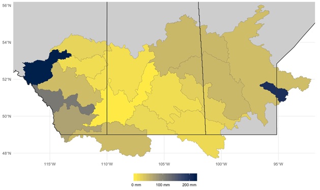
Image source is WaterSMART Solutions (2020), used with permission.
As you can see, most of the water in the Prairies originates in the steep terrains of the Rocky Mountains (dark blue area) where there is high precipitation. By contrast, there are vast areas throughout the Prairies that receive little precipitation and have very flat terrain (yellow areas). These yellow regions contribute very little water to the rivers, and they rely on the water that flows in an easterly direction from the Rockies for their municipal, industrial and agricultural supplies.
Projected Future Air Temperature Changes by Season
The figure below shows the projected changes in air temperature in the Prairies in each of the four seasons by 2040. The darkest red represents the greatest projected change, which is approximately 2.5 degrees Celsius. The light yellow represents the smallest projected change, which is approximately 1 to 1.5 degrees Celsius.
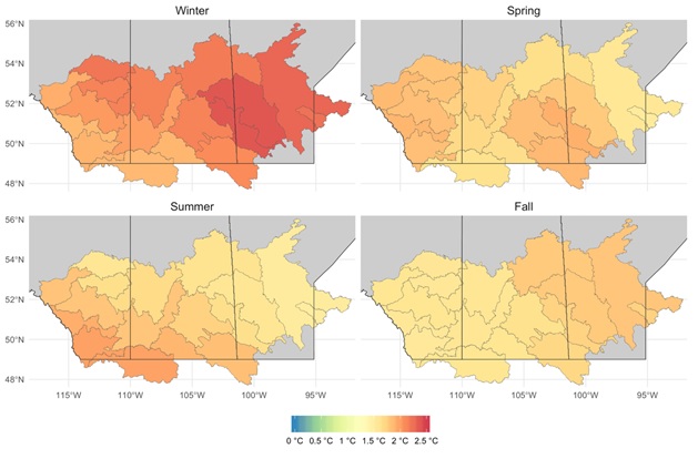
Image source is WaterSMART Solutions (2020), used with permission.
Note that there are no blue regions on any of the maps. This lack of blue means that by 2040, no region of the Prairies is projected to have an average temperature similar to what we are currently experiencing.
In this picture showing winter, spring, summer and fall, air temperature increases are expected to be highly seasonal. The greatest increase in air temperature from present time is seen in the winter season and different areas of the Prairies may have greater increases in temperature during some seasons than other areas.
Because climate change impacts are seasonal, there are implications, including the following:
- The timing of water availability will change. For example, snow in the mountains will melt earlier, making less water available in the late summer months.
- There will be increases in the number of growing days for agricultural operations.
- Increased evaporation rates will mean water stored in reservoirs evaporates faster.
- Winter temperatures are predicted to increase and more precipitation is expected to fall as rain, shifting peak streamflow to earlier in the spring
Projected Future Total Annual Precipitation Changes
The figure below shows how total annual precipitation could change across the Prairies by the 2040s due to climate change.
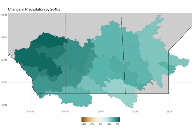
Image source is WaterSMART Solutions (2020), used with permission.
The dark green areas indicate an expected large increase in precipitation over the time period, whereas the lighter green areas indicate that more precipitation is expected but to a lesser extent.
Note that there are no areas expected to see an overall decrease in precipitation, and that every region of the Prairies will experience some level of change.
Because of these increases in precipitation, there may be consequences for the people living and working in the region. Flooding, in particular, may become an issue for settlements located near major rivers, and heavy rain events or snow storms may cause damage to infrastructure. Agricultural activity could also be affected by increases in precipitation, as many crops thrive under very specific growing conditions.
Projected Future Seasonal Precipitation Changes
The figure below shows how seasonal precipitation could change by the 2040s across the Prairies due to climate change.
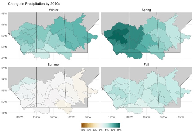
Image source is WaterSMART Solutions (2020), used with permission.
The dark green areas indicate a large increase in precipitation whereas the white and gold areas indicate a similarly large decrease in precipitation.
You can see that in the winter and especially the spring (top right map), it is projected that the Prairies will experience more precipitation than we currently experience. By contrast, in the summer (bottom left map) it is projected that the Prairies will have less precipitation by 2040.
These types of precipitation changes will impact the environment and the people living in the Prairies. For example, an area experiencing a wetter spring but a dryer summer may run into water scarcity issues and rationing may be required. Other implications include:
- Increasing summer air temperatures combined with little to no change in summer precipitation is likely to result in hotter, drier periods and increased drought.
- Increasing air temperature and increasing spring precipitation is likely to result in more extreme weather events including wildfires, flooding, heat waves, and drought.
Sources:
WaterSMART Solutions. (2020). Appendix B: Hydrology Baseline Summary Report, prepared for Western Economic Diversification Canada/Diversification de l’economie de l’Ouest Canada.