Climate Change in the Athabasca River Basin
Characteristics of the Athabasca River Basin
Spanning approximately 159,000 square kilometres, the Athabasca River Basin (ARB) covers 24% of Alberta1. The headwaters of the ARB begin at the snow dome Columbia Icefields in Jasper National Park, also referred to as the hydrological apex of North America. The ARB continues into the northeastern corner of Alberta and western Saskatchewan, draining into Lake Athabasca through the Peace-Athabasca Delta.
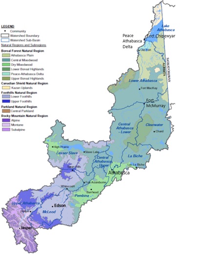
Image adapted from the Athabasca Watershed Council2.
There are four distinct Natural Regions in the ARB including the Rocky Mountains, Foothills, Boreal Forest and Canadian Shield. Each Natural Region has its own distinct climate and physical geography.
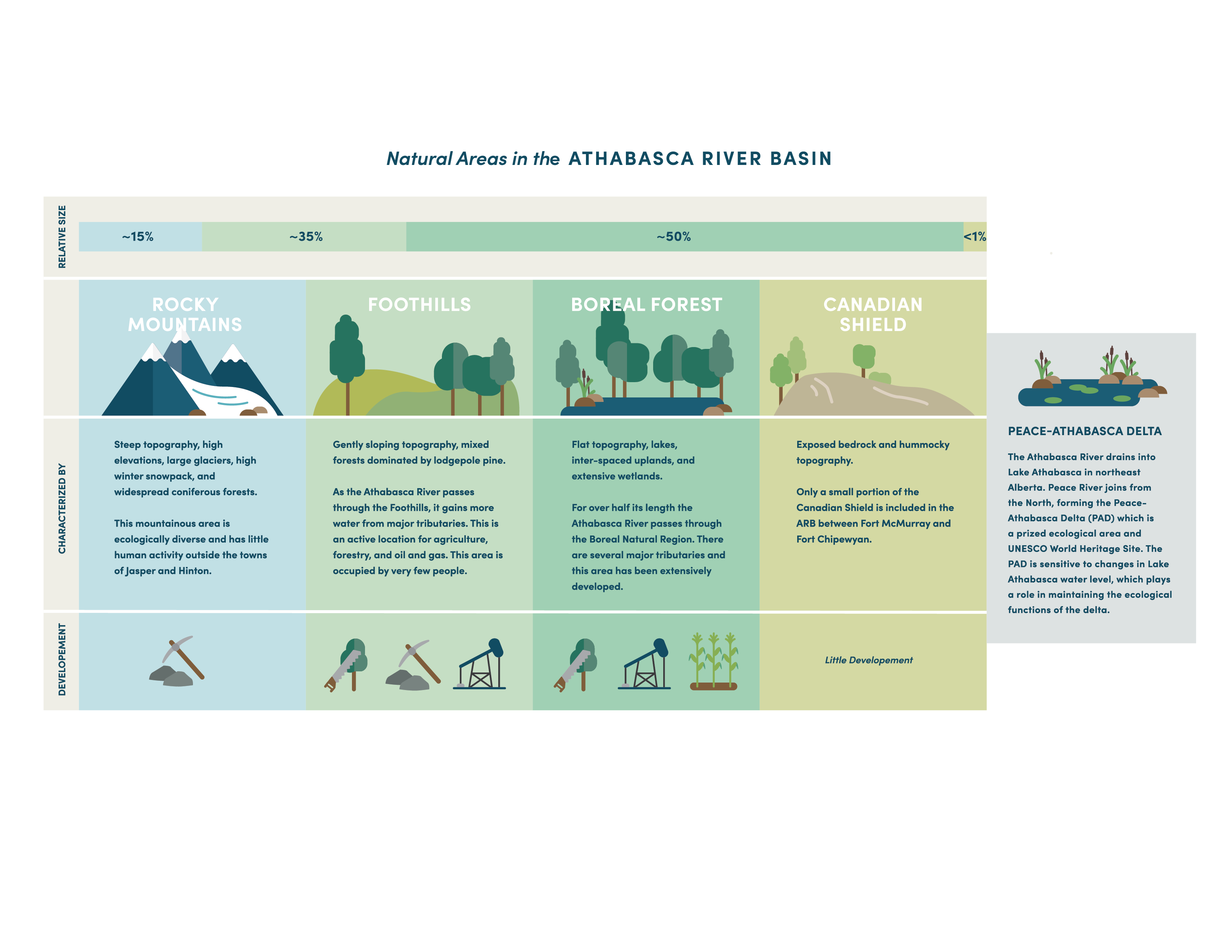
Image adapted from WaterSMART Solutions (2018)3.
With a density of only one person per square kilometer, the population of the ARB is sparce, especially compared to most other regions of Alberta4. The region does, however, contain abundant natural resources including water, forests, coal, oil and gas, minerals, and agriculture5. These resources are the economic engines of the region and provide livelihoods for those living in the area.
The Athabasca River plays an important role in supporting the ecosystems in the ARB. In particular, the area where the Peace and Athabasca Rivers meet near Lake Athabasca, called the Peace-Athabasca Delta, is one of the most ecologically significant areas in the world and is a designated UNESCO World Heritage Site.
Climate of the Athabasca River Basin
To determine the climate of a region, scientists compile data from various instruments including air temperature sensors and precipitation gauges. In the ARB, the climate is not the same across the entire region. This variability is because the Basin covers a large area and because there are so many differences in the four Natural Regions, including average air temperature and precipitation levels.
To provide a rough understanding of the climate across the ARB, the table below shows average air temperature and precipitation at four locations. The data are from the instrument record compiled by Environment Canada.
| Location | Natural Region | Average maximum temperature for summer days (oC) | Average maximum temperature for winter days (oC) | Average total precipitation during summer (mm) | Average total precipitation during winter (mm) |
| Jasper | Rocky Mountains | 21 | -3 | 153 | 136 |
| Hinton | Foothills | 23 | -2 | 242 | 100 |
| Athabasca | Boreal Forest | 23 | -4 | 324 | 133 |
| Fort McMurray | Boreal Forest | 22 | -8 | 214 | 97 |
Because the instrument record is relatively short (only approximately 100 years), scientists use information from the natural world to gain a better understanding of what the climate looked like thousands of years ago. Old trees, for example, provide a record of wet and dry years because the amount of growth each year is dependent on the amount of water available to the tree.
In the ARB, tree ring data from the past 900 years shows that there was much more variability and greater climate extremes than can be seen in the relatively short instrument record6. The tree rings show periods of wet weather that lasted for one to two decades, as well as periods of drought lasting over ten years that resulted in low flows in the Athabasca River 6.
This information is significant because what happened in years past will theoretically happen again. Because of climate change, people living and working in the ARB need to be prepared for the possibility of even greater climate variability and extremes, as well as an overall trend of warming.
Impacts of climate change on water
Climate projections for the ARB show that the Basin will likely experience warmer air temperatures and more precipitation in the future. Specifically, there will likely be much warmer and wetter winters, with warmer and slightly wetter summers.7 8
The models also project that the climate could be increasingly variable from year to year, and may be very different from one decade to the next. Therefore, although the trend is toward warmer and wetter, there are also likely to be serious droughts at times, resulting in occasions where there are very low water flows in the rivers.
The ARB includes mountain areas with glaciers which typically begin to melt in July and August of each year. Glacial melt contributes up to 20 per cent of the total streamflow in the Athabasca River. The timing of this melt is critical, as the extra water comes when agriculture and other industries typically need more water because it is hot and there is less rain. Because climate change is expected to result in warmer air temperatures across the ARB, snow will likely melt earlier in the spring and glaciers will likely melt faster8. This change in timing could negatively impact water supplies in the Athabasca River because less water would be available in the late summer when it is most needed. There could also be increased flooding in the spring and early summer if too much snow melt comes at the same time as heavy rain events.
The extra precipitation that is projected will likely result in more water available for the whole year, but the timing of when it enters the river is important to consider. Later summer is the time when the river is typically at its lowest flow and the ecosystem is potentially most stressed, but there is still high demand for water for many different human activities. Because of the projected decline in glaciers, it is projected that summer flows in the Athabasca River in 2080 could be 21% lower on average than they are now.9
Sharing water in the Athabasca River Basin
Because of the projected changing climate in the ARB, water users in the region can expect the following challenges:
- Snow will likely melt earlier in the year, resulting in:
- Lack of water or less water available for communities and industrial activities.
- The potential for more floods and droughts.
- Crop failures due to water shortages in the late summer and too much water in the spring.
- Changes to recreational opportunities such as fishing, swimming and rafting that rely on expected water levels and flow rates.
- Changes to traveling by boat (navigation) on the Athabasca River, which is very important for many communities and for economic activity. Low flow in the river can make it difficult or impossible to travel
- The increased variability in precipitation could impact water quality and ecosystem health. Wetland ecosystems are particularly vulnerable to changes in climate and water supply, as increases in air temperature can promote the growth of undesirable plants and bacteria. Changes in precipitation can also cause harm to animals who require water at specific times of year.
- The variability in precipitation could also result in more extreme weather events such as flooding, which could impact the communities and industries operating in the Basin.
- Plants are projected to experience increased water stress because the timing of precipitation changes will cause dry periods in the late summer months10. As well, aquatic ecosystems may be impacted by changing stream flow. For example, fish that rely on higher river levels to spawn in the fall may face challenges, and species that need cold water may not thrive in warming creeks. Warm-water adapted species may become more common.
Water for the future and how you can contribute
In the future, it is likely that the ARB will receive more water at unpredictable and inconsistent times of the year. This variability creates the necessity for adaptability and resilience, especially in terms of community planning. Examples of resilient community planning include building homes and infrastructure farther away from river banks, ensuring bridges are built to withstand higher river waters, and passing legislation so that toxic waste is stored where it will not enter the river systems in the event of an unexpectedly large flood.
Communities also need to protect ecosystems as a means of ensuring resiliency against climate change. Wetlands, for example, are particularly important for moderating streamflow and will help protect downstream communities from extreme wet weather events. In the ARB, high priority ecosystems should be identified and safeguarded.
And finally, ensuring water availability in the future is essential. A few ways to work towards this include:
- Upstream and downstream water users can work together by alternating when they are withdrawing from the river. This cooperation will help keep an ample supply of water in the river more consistently.
- Upstream communities can engage in water conservation and water quality management to ensure that their downstream neighbours have a clean and reliable source of water.
- Different sector water users can develop partnerships to reuse water, such as municipal wastewater being reused by the oil and gas industry.
Sources
- Athabasca River Basin Research Institute. (n.d.) About the Athabasca River Basin. Retrieved from http://arbri.athabascau.ca/About-the-Athabasca-River-basin/Index.php.
- Athabasca Watershed Council. (2018). State of the Athabasca Watershed: Summary Report. Retrieved from https://awc-wpac.ca/wp-content/uploads/2018/12/Athabasca-SoW-Summary-FINAL-DRAFT.pdf.
- WaterSMART Solutions. (2018). A Roadmap for Sustainable Water Management in the Athabasca River Basin (ARB Initiative) Overview Document. Retrieved from https://watersmartsolutions.ca/knowledge-base/athabasca-river-basin-initiative-the-arb-initiative/
- Alberta Water Portal Society. (2012). Hydrological Modelling of Alberta: Athabasca River Basin. Retrieved from https://albertawater.com/hydrological-modelling-of-alberta/water-availability/athabasca-river-basin#:~:text=The%20Athabasca%20Basin%20is%20about,5%25%20of%20the%20provincial%20population
- Ibid, About the Athabasca River Basin.
- Sauchyn, D.J., St-Jacques, J-M., and Luckman, B.H. (2015). Long-term reliability of the Athabasca River (Alberta, Canada) as the water source for oil sands mining. PNAS, 112 (41) 12621-12626. Retrieved from https://www.pnas.org/content/112/41/12621
- Alberta Water Portal Society. (2018). About the Athabasca River Basin Initiative. Retrieved from https://albertawater.com/athabasca-river-basin-initiative
- Canadian Water Resources Journal. Current and Future projections of glacier contribution to streamflow in the upper Athabasca River Basin. (2020). Retrieved from https://www.tandfonline.com/doi/abs/10.1080/07011784.2020.1815587?journalCode=tcwr20
- Journal of Hydrology. (2016). Climate-induced alteration of hydrologic indicators in the Athabasca River Basin, Alberta, Canada. Retrieved from https://www.sciencedirect.com/science/article/abs/pii/S0022169416307405
- Science of the Total Environment. (2017). Assessing climate change impacts on fresh water resources of the Athabasca River Basin, Canada. Retrieved from https://www.sciencedirect.com/science/article/abs/pii/S0048969717311099