Climate Model Scenarios and Glacier Projections

Future projections of the glacier cover on the eastern slopes, including a simple model of glacier dynamics, provide estimates of how glacier volume and runoff may change in the coming decades. If climate stabilizes such that mass balance rates like those of the 2000’s persist through the 21st century, about 40% of the glacier ice in the Rocky Mountains will disappear this century. If climate change continues as per the projections from climate scenarios, we estimate an 80% to 90% decrease in glacier volume by the end of the century.
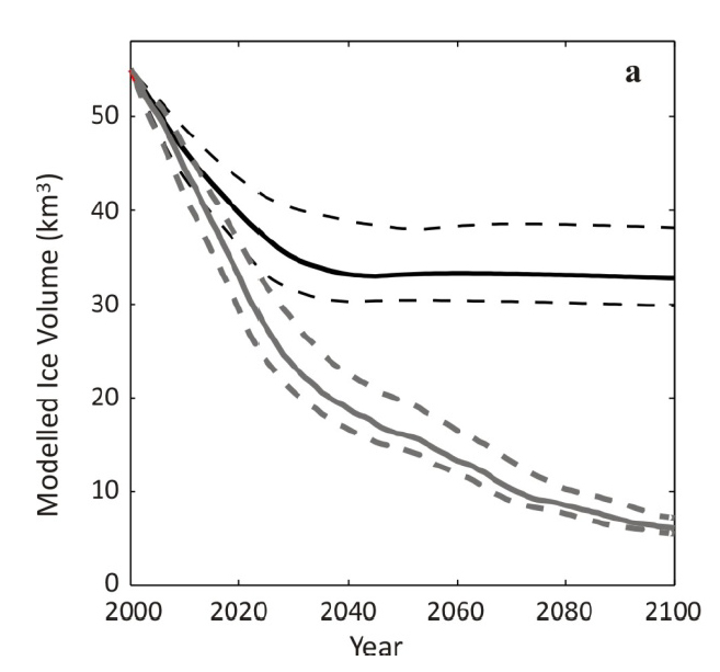
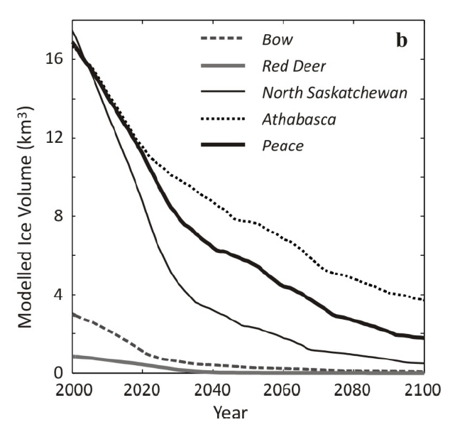
The projected glacier demise is severe for this century. The charts (below) show ice volume forecasts over the next century, for:
- Chart-A: all basins on the eastern slopes of the Rockies
- Chart-B: individual river basins, for different mass balance scenarios (combined with a model of glacier dynamical response to this forcing)
Chart A (all basins, eastern slopes)
The top line in Chart-A illustrates the expectations if glacier mass balance rates from 2000-2007 are maintained for the rest of the century. This is what would be expected if climate stabilized at its recent mean state. The model predicts several decades of ice loss, with equilibration by 2040. Even with immediate stabilization of climate, 31% to 46% of the current glacier volume on the eastern slopes is lost in this ‘static climate’ scenario, with an estimate of 40% for the reference model.
The lower curve in Chart-A represents the more realistic forecast if the planet continues to warm, with steeper rates of ice loss and ongoing glacier retreat throughout the century. Relative to the case with fixed present-day climate/mass balance, rates of ice loss are greater and glacier retreat continues throughout the century, with no stabilization. This amounts to a loss of 79-89% of glacier volume on the eastern slopes by 2100.
About 60% of the remaining ice is in the Athabasca Basin, in the upper plateau region of the Columbia Icefield: the headwaters of the North Saskatchewan and Athabasca Rivers. The equilibrium line altitude (ELA) rises above a critical elevation threshold for glaciers in the southern river basins under the future climate scenarios, while glaciers in the Peace and Athabasca basins have greater resilience.
Chart B (by river basin)
Chart-B illustrates that glacier retreat differs between the various river basins. In all basins the geometric evolution of the glacier – the retreat to higher elevations – helps to stabilize the glaciers and extend their lifetime. Mass loss declines with time, and the cumulative loss is much less than that predicted from extrapolation of recent rates of decline.
The Bow, Red Deer, North Saskatchewan, and Peace basins see losses of 66%, 71%, 57%, and 44% of current ice volume by 2100. Athabasca basin ice masses are more resolute in this simulation, losing only 13% of present-day ice volume.
While Chart-B plots the projected ice volume evolution for individual river basins, there is also the corresponding glacier discharge: the expected contributions to Alberta’s rivers from glacier volume loss. Modelled glacier runoff represents the release of water that has been in long-term storage in the glaciers. Melting and runoff of seasonal snow augments this glacier volume change and dominates the discharge in glacierized basins in early summer, but is not included in these calculations or discharge forecasts.
Projected glacier contributions to streamflow indicate substantial declines through the 21st century, with glacier inputs decreasing from 1.1 km3 w.e. in the early 2000s to less than 0.1 km3 w.e. by the end of the century. These impacts on the river systems will be concentrated in late summer.
Download
Alberta Glacier Inventory and Ice Volume Estimation (3.49 MB)


