Area and Number of Glaciers in Alberta
Glacierized Area
The WC2N or Bolch et al. (2010) inventory estimates a total of 17,595 glaciers in B.C. and Alberta in 2005, covering 26,728 km2. Since most of these glaciers reside west of the continental divide, the 2005 inventory identified 1,167 glaciers in Alberta, covering an area of 786 km2. Note that fragmentation of ice masses gave rise to an increase in Alberta’s glaciers from 926 to 1,167 (over the period 1985 to 2005), despite a 25.4% loss in total glaciated area.
We based our analysis on the glacier coverage maps of Bolch et al. (2010), but perform our own subdivision of Alberta’s glaciers, identifying 741 independent ice masses covering 791 km2. This is inconsistent with the glacier count of Bolch et al., but our estimated glacier areas are in good agreement.
Table 1 (below), compiles statistics on the present day (~2005) count and area distribution of Alberta’s glaciers. This is a telling story… of Alberta’s 741 remaining glaciers, 81% are smaller than 1 km2. These small glaciers account for only 23% of the glaciated area in Alberta, while the 14 major icefields and valley glaciers that are larger than 10 km2 make up 34.7% of the total glaciated area.
Table 1. Alberta glacier area statistics, 2005, from the WC2N inventory
| Size Range (km2) | Glacier Count (n) | Glacier Count (%T) | Glacier Area (km2) | Glacier Area (%T) |
| 0.05 − 0.1 | 109 | 14.7% | 8.0 | 1.0% |
| 0.1 − 0.5 | 378 | 51.0% | 90.6 | 11.4% |
| 0.5 − 1.0 | 116 | 15.7% | 83.3 | 10.5% |
| 1 − 10 | 124 | 16.7% | 334.9 | 42.3% |
| 10 − 40 | 14 | 1.9% | 274.6 | 34.7% |
| Total | 741 | 100% | 791.4 | 100% |
Table 2 (below), compiles the same information, but includes the B.C. portions of the Peace River basin that drain eastwards into Alberta, and offers a more realistic inventory of the glacier water resources that feed Alberta’s rivers. Inclusion of these ice masses raises the glacier count and area to 1,010 and 960 km2.
Table 2: Glacier area statistics, 2005, for the entire eastern slopes of the Canadian Rockies, including B.C. portions of the Peace River Basin
| Size Range (km2) | Glacier Count (n) | Glacier Count (%T) | Glacier Area (km2) | Glacier Area (%T) |
| 0.05 − 0.1 | 165 | 16.3% | 12.1 | 1.3% |
| 0.1 − 0.5 | 525 | 52.0% | 125.6 | 13.1% |
| 0.5 − 1.0 | 150 | 14.9% | 106.5 | 11.1% |
| 1 − 10 | 154 | 15.2% | 406.1 | 42.3% |
| 10 − 40 | 16 | 1.6% | 309.8 | 32.3% |
| Total | 1,010 | 100% | 960.1 | 100% |
Terrain Characteristics of Glaciers in the Eastern Slopes of the Rockies
Glacier cover on the eastern slopes of the Rockies spans elevations of 1,556 to 3,721 meters, the latter being the Alberta’s high point, Mt. Columbia. The median elevation of the province’s glaciers is 2,620 meters; 50% of Alberta’s glaciated area lies above this elevation and 50% below. The minimum and median elevations of Alberta’s glaciers decrease with latitude, reflecting the cooler temperatures and shorter, less intense summer melt season in northern Alberta. Glaciers extends to lower elevations at the higher latitudes of the B.C. portions of the Peace Basin, with the median glacier elevation in the Peace Basin, 2,208 meters, considerably lower than that of Alberta’s glaciers.
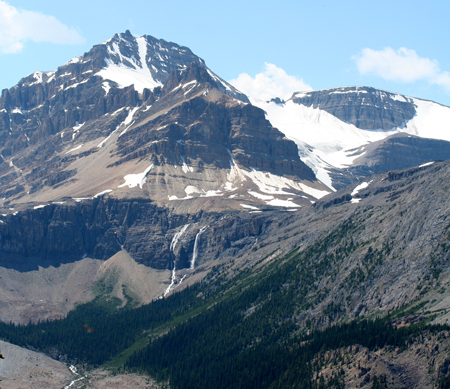
In Table 3 (below), we separate the glacier cover in each of Alberta’s glaciated basins: the Bow, Red Deer, North Saskatchewan, Athabasca and Peace. Alberta’s glaciers are concentrated in the headwaters regions of the North Saskatchewan and Athabasca Rivers, with over 77% of the glacierized area found here. Much of this is in the Columbia Icefields region. Headwaters regions of the Peace River in northern B.C. also contain significant amounts of glacier ice.
Table 3: Glacier area and elevation distributions for Alberta river basins, based on the WC2N glacier inventory for 2005
| River Basin | Glacier Count (n) | Area (km2) | Elevation (m) (min) | Elevation (m) (median) | Elevation (m) (max) |
| Bow | 96 | 60.3 | 1,972 | 2,620 | 3,473 |
| Red Deer | 22 | 16.6 | 2,441 | 2,729 | 3,084 |
| North Saskatchewan | 258 | 286.2 | 1,566 | 2,610 | 3,464 |
| Athabasca | 271 | 321.3 | 1,556 | 2,560 | 3,721 |
| Peace (AB) | 94 | 107.6 | 1,640 | 2,457 | 3,270 |
| Peace (AB and BC) | 363 | 276.6 | 1,424 | 2,208 | 3,270 |
| Alberta | 741 | 791.4 | 1,550 | 2,620 | 3,721 |
| All eastern slopes | 1,010 | 960.1 | 1,424 | 2,507 | 3,721 |
Hypsometry and Glacier Aspect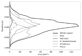
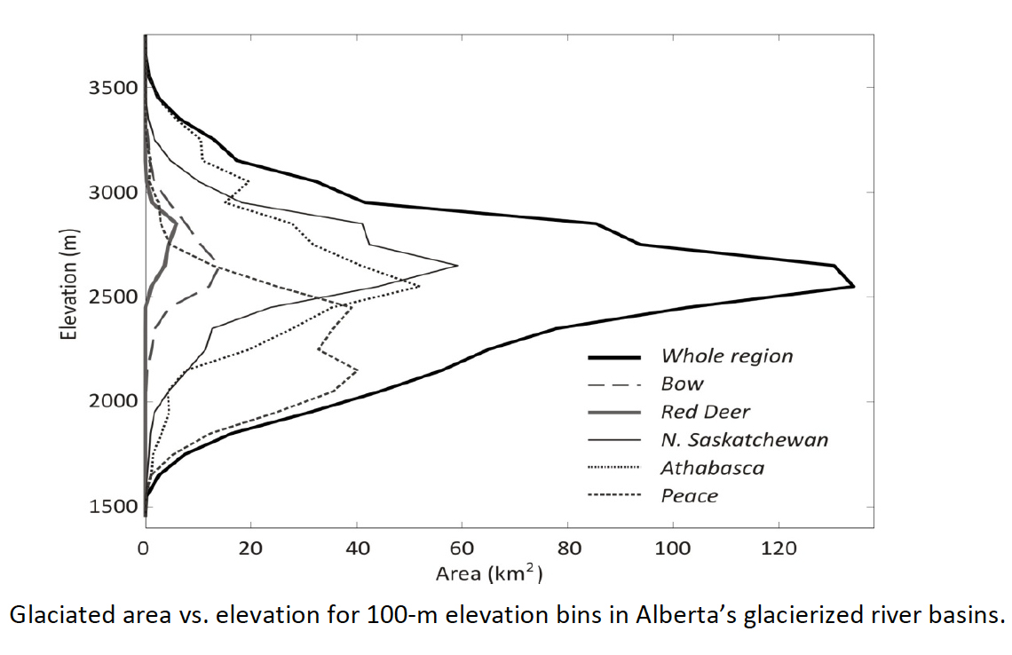
The diagram (right) plots the hypsometry (area vs. elevation distribution) of glacier cover in each basin and for the whole region. The data reveals that most of the glacier ice on the eastern slopes resides at an elevation range of 2,300 – 2,800 meters (above sea level). The end-of-summer snowline, or equilibrium line altitude (ELA), is typically found at these elevations in the Canadian Rockies, although the ELA frequently rises above these elevations.
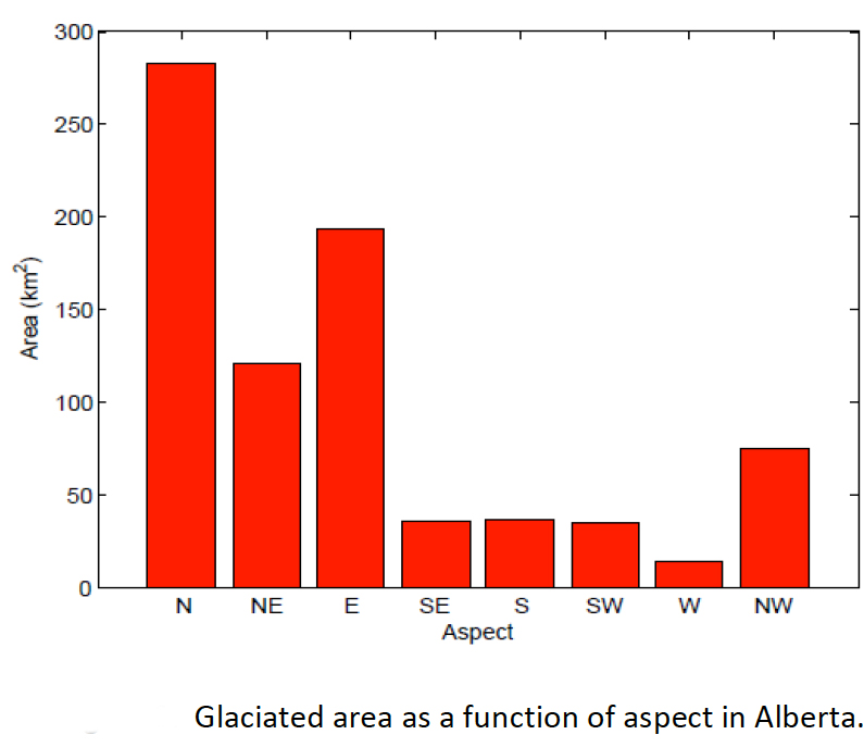
Glacier aspect is another factor that is critical to glacier melt, as north-facing slopes experience less incident solar radiation and a less energetic melt regime. The distribution of Alberta glaciers by aspect is shown in the diagram (below). Because we are analyzing only the eastern slopes of the Rockies, there is a strong easterly component to the ice cover. Despite this bias, Alberta’s glaciers are predominantly north facing, with 60% of the glaciated area having a northwesterly, northerly, or northeasterly aspect.
Download
Alberta Glacier Inventory and Ice Volume Estimation (3.49 MB)