Ice Jams: frazil ice, freeze up, and floods
What are ice jams?
As temperatures drop and river levels decrease, the yearly phenomenon of river “freeze up” begins to take place all over Alberta. The formation of ice on a river, or “freeze up”, can take place suddenly as weather fluctuates within a few days, or after long periods of consistently cold temperatures. Natural variation in local weather, river depth, width, flow regimes, and many other factors can influence how the ice forms; formation varies from uniformly stable, insulating ice covers to massive, irregular blocks of ice and everything in between.
It is this variability in conditions and resulting ice formation that influences the potential for flooding. In the best-case scenario, the ice layer that develops on top of a river creates insulation from the cold air, limiting the total amount of ice formation. However, in many situations, river freeze up is not so simple, and can result in ice jams that restrict river flow and cause flooding in the surrounding area. Ice jams are a natural part of the winter ice cover regime, and have been documented in Alberta from Hay River in the North all the way to the south in the Milk River.
How do ice jams form?
Ice formation begins with tiny crystals of frazil ice that form in turbulent, supercooled waters and stick together to form larger pans or flocs of suspended ice. Frazil pans can often be seen floating down the river during the first few weeks of winter.
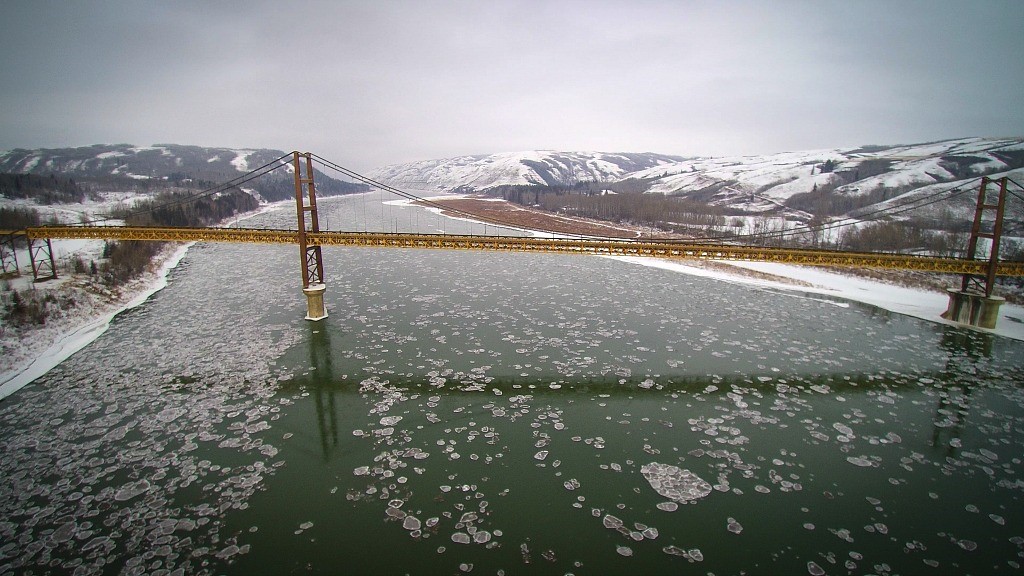
Figure 1 Frazil ice pans forming near the Dunvegan Bridge on the Peace River, Alberta. Image Source: U of A news article
At a certain point, the frazil pans begin to jam into one another and form the ice cover. As more frazil pans accumulate, the edge of the ice cover (known as the ice front) starts moving upstream of the jam location. Ice fronts moving at speeds of 14km/h have been observed (Cairny, 2015). For comparison, an average person running clocks in at around 9km/h! Ice fronts often begin at river deltas, where the flowing water meets standing water in a lake or reservoir that has an intact ice cover against which ice can accumulate. River confluences, where two rivers meet to form a larger body of water, can also predispose a location to ice jam formation. During freeze up and throughout the cold season other types of ice can also form, such as anchor ice, hanging dams, and even snow that becomes icy slush.
In general, ice jams form at locations where there are constrictions on the river, such as:
- tight bends or narrow sections
- islands or shallow bars
- bridges
- changes in channel form (i.e. river confluences and changes in river bed slope)
Some examples of places built on or near river deltas or confluences that experience annual or nearly annual ice jamming:
- Peace River, AB (Peace-Smoky confluence)
- Hay River, NWT (Hay River delta at Slave Lake)
- Fort McMurray, AB (Athabasca-Clearwater confluence)
- Tornio, Finland (Torne River delta at the Gulf of Bothnioa)
- St-Raymond, QC (Northern Arm of the St Anne River at the St Anne River)
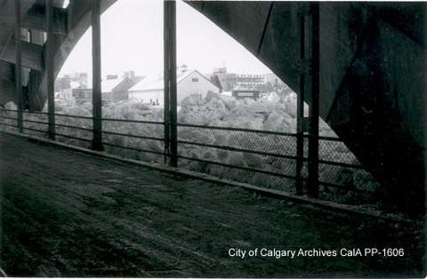
Figure 2 Ice jam on the Bow River next to the Center Street Bridge in Calgary, 1959. Source: City of Calgary Archives.
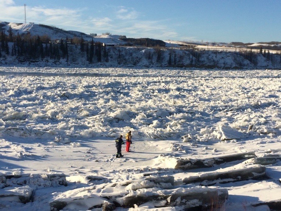
Figure 3 High water mark survey following freeze-up in the Town of Peace River in January 2015. No flooding was reported. Photo courtesy of Alberta Environment and Parks.
The counterpart to freeze up is known as break up, and takes place at the end of the winter season as temperatures start to rise with the onset of spring. When the ice begins to break into pieces that can move independently, the risk of an ice jam increases. April is the most common month for ice jams because higher temperatures melt snow upstream and in turn, the release of water can contribute to ice breaking up and being set in motion. As ice pieces come together and accumulate downstream, an ice jam can form.
As with freeze up, break up can take place through different mechanisms resulting in a variety of ice conditions that may or may not be problematic in terms of flooding. Timing of peak river flow generally correlates with river ice break up, when ice and snow in the headwaters begins to melt with the beginning of spring. Break up ice jams in the spring are more common on north-flowing rivers, which account for approximately 60% of Canada’s river drainage, such as the Peace and Athabasca Rivers. When the southern part of the river basin experiences warmer temperatures, the early snowmelt runoff flows north, encountering stronger and less deteriorated ice as it runs downstream. The increasing water levels associated with the runoff can lift and break this stronger ice cover and form ice jams.
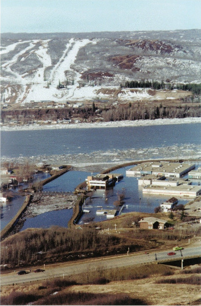
Figure 4 Peace River breakup flooding in 1997. Photo courtesy of the Peace River Museum.
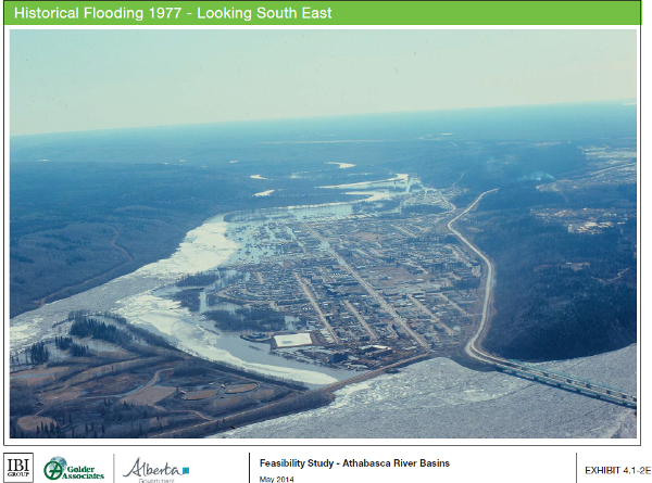
Figure 5 Lower Townsite and Waterways of Fort McMurray situated at the confluence of the Athabasca and Clearwater Rivers. Fort McMurray lies within the Clearwater floodplain, and is prone to flooding from ice jams. Source: IBI Group and Golder Associates Ltd, 2014. Feasibility Study – Athabasca River Basins. Prepared for the Government of Alberta – Flood Recovery Task Force.
All of these different ice formations like jams, hanging dams , and frazil pans share one very important characteristic; they restrict water flow through the river channel. When water cannot flow easily through its natural channel, it seeks alternative ways of continuing its journey downstream, regardless of whether those alternative paths contain homes, people, and infrastructure. River waters take the path of least resistance.
How do ice jams impact Albertans?
Ice-related flooding events, as with ice formation during freeze up and dissolution during break up, are highly variable, difficult to predict and evaluate, and often disastrous. Flood stages (flood producing water levels) are difficult to estimate from gauge sites (locations on the river that measure water levels) because ice jam flooding impacts a smaller reach of the river than open water (ice free) events (Carr, Gaughan, George, & Mason, 2015). In addition to being hard to predict, ice jam floods unfortunately frequently result in higher water levels and more extensive damage than open water events, making them a serious concern for riverside communities in temperate climates conducive to river ice formation (Burrell et al., 2015).
Damages from an ice jam flooding event can be similar to those experienced during open water flooding events, including property and infrastructure damage and human health and safety impacts. Annual damages due to ice jams have been estimated at $138 million in the US (Carr, Gaughan, George, & Mason, 2015). In 1963, the town of Hay River relocated its downtown centre in response to ice jam related flooding (Burrell et al., 2015). On February 28, 1992, approximately 3800 residents of Peace River, Alberta were evacuated from their homes as temperatures reached record highs following a large snowfall. The snowpack melted quickly into rivers and streams, causing widespread flooding as the water encountered ice jams, causing it to overflow the river banks. Five years later, in April 1997, another heavy snowpack and rapid melt resulted in evacuation of approximately 4000 residents of Peace River, as ice jams on the Peace River caused the Heart River to overflow its banks. The total cost of the 1992 event was estimated at $2.9 million, while the 1997 flood is thought to have cost $47 million and resulted in damage to 50% of the businesses and hundreds of bridges and roads.
Large scale evacuations in Alberta due to an ice-related flooding event
Fort McMurray 1977
April 12-14, 1977. The Athabasca River broke up at the Town of Athabasca around noon on April 12, after a week of unseasonably warm temperatures. A large breakup flood wave arrived in Fort McMurray early in the morning of April 14, resulting in an ice jam at the highway bridge which increased local water levels by approximately 5 m. An hour later, the ice jam pushed its way downstream, lodging itself downstream of town and pushing ice up the Clearwater River. Water levels at the bridge peaked at 5.7 m above pre-freeze-up levels, and flooding occurred in Fort McMurray along the Snye (Clearwater River). (Public Safety Canada, 2013)
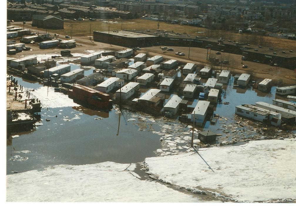
Figure 6 Fort McMurray, April 1997. Photo courtesy of Alberta Environment and Parks.
Peace River 1992
February 28 – March 4, 1992. Unseasonably warm weather following a large snowfall broke up the frozen Peace River, resulting in ice jams which caused water levels to rise 4.3 m above the average. Quickly melting snowpack in upstream rivers and streams contributed to the rapid rise of water levels. According to Public Safety Canada, extensive flooding necessitated the evacuation of approximately 3800 residents of the town for at least three days; approximately 20 homes sustained severe damage, 30 others were damaged but could still be occupied; no deaths or injuries were reported. (Public Safety Canada, 2013)
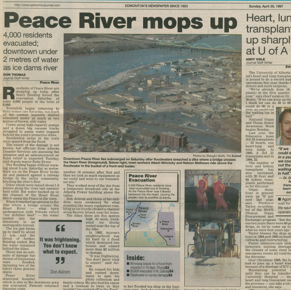
Figure 7 Peace River newspaper from April 20, 1997 describing aftermath of the flood caused by ice jams. Photo courtesy of Alberta Environment and Parks.
Peace River 1997
April 19-23, 1997. Heavy snowpack and a rapid snowmelt caused ice jams on the Peace River which backed up water on the Heart River, causing flooding in the Town of Peace River. According to Public Safety Canada, 50% of the businesses in the Town of Peace River were damaged, along with 20 farm homes. In some areas, the flood waters reached levels of up to 2m. A State of Emergency was declared in the Town of Peace River, and 4000 people were evacuated. (Public Safety Canada, 2013)
Fort McMurray 1997
April 20-21, 1997. A rapid snowmelt of the snowpack in the Athabasca basin precipitated a large ice run on the Athabasca River, which formed a jam on April 20. The ice jam formed 2 km downstream of the confluence between the Athabasca and Clearwater rivers. As a result of the ice jam, water levels on the Clearwater River backed up, increasing local water levels by 4.38m. The Clearwater River overtopped its banks in the vicinity of the Riedel Street trailer park, and the Waterways neighbourhood, flooding low lying areas. Approximately 75 trailers and/or houses required evacuation, and some 20 businesses were affected. A state of emergency was declared on April 21st. (Public Safety Canada, 2013)
Climate change impacts on river ice processes
For much of Alberta, river ice is a reality that must be managed to minimize risk to people and infrastructure. There are many examples of naturally occurring phenomenon that, like ice jams, create risks that must be mitigated on an ongoing basis. Other severe weather events like flooding, drought, hailstorms, etc. are natural ecosystem functions, but can pose a risk to human health and safety. These are natural fluctuations in our natural system that are simply part of life in Alberta, to which we have adapted to the best of our abilities. However, the climate is changing and the variability of these systems is expected to increase, resulting in more frequent and harder to predict extreme severe weather events. Read more about climate change and variability here. It is difficult to predict what the effects of climate change will be on river ice processes (and subsequently ice jams) for each river in Alberta, but we can connect some of the ice processes with shifting weather patterns predicted as a result of climate change.
Ice jams are only one part of the river ice formation process, which is governed by many factors like streamflow, ice thickness and strength, and stream morphology. These factors may in turn, be influenced by surrounding weather conditions or previous extreme weather events (impacting the river channel or surrounding landscape). For instance, rising temperatures with a changing climate are predicted to reduce the ice season duration by 2-4 weeks in the Peace River basin. Ice cover is predicted to be thinner than it is today, and the frequency of mid-winter thaws is predicted to increase. These thaws are expected to reduce snowpack in the region and, in combination with the shifts in ice cover, are predicted to reduce the frequency of ice jam flooding (Beltaos et al., 2008). Many river basins predict a shift in the timing and magnitude of peak streamflow, which are an important factor in determining whether a particular ice jam will lead to a flooding event or not (Beltaos & Prowse, 2001). Large differences exist between the many places that experience ice jams in terms of all processes leading to ice formation and ice jam flooding, such as geography, climate, land use, etc. Understanding these processes at a local and regional scale will be critical for mitigating potential impacts of climate change and adapting to the changes in river ice processes.
How are ice jams managed?
River ice formation is a natural process occurring because of numerous factors often beyond our control, such as climate, local weather, river or stream channel characteristics and flow regimes; communities that experience ice jams on a regular basis have learned to adapt and develop ways of managing river ice to minimize negative impacts. Ice management techniques range from using direct methods, i.e. dropping bombs and detonating dynamite, to indirect methods like maintaining local and regional ice observation report databases throughout the ice season. Between these two extremes are a wide range of techniques that help cities and towns predict, monitor, and react to river ice.
Ottawa’s ice dam busters use dynamite to break up river ice on the Rideau River.
Hydroelectric dams built on rivers that experience ice formation can alter the winter thermal regime, meaning they can change the timing and manner of freeze and break up as well as ice properties (Parmley et al., 1990). Reducing water flows during freeze up can encourage formation of an ice cover, which limits total ice formation as it creates an insulating layer for the remainder of the season. Controlled water release during break up can reduce the risk of a sudden, dynamic breakup and subsequent flooding downstream. Upstream of the dam, however, no such effects exist and the risk of ice jams may be significantly increased. Conflicting priorities can also be factors in management of downstream river ice at a hydroelectric dam that was built with the primary intention of producing power. Varying the level of flows to meet power demands (hydropeaking) can cause water levels to fluctuate, and can destabilize, collapse, or thicken ice covers.
Channel modifications and infrastructure are also methods used for flood control. In St. Raymond, QC the following flood control interventions have been performed over several decades (Burrell et al., 2015);
- Dikes and walls to protect river banks from overflowing,
- Channel dredging and island removal to provide more space for the river during high flows,
- Channel straightening to reduce potential jam locations, and,
- Ice control structures consisting of a weir with concrete piers to initiate stable ice covers or initiate jams upstream of vulnerable areas.
River advisories issued by Alberta Environment and Parks provide details of the behaviour of the ice and corresponding water levels that could change, along with a summary of weather and effects on the ice, and notes about ground observations and upstream hydroactivity. Some towns, including Peace River, work closely with the Alberta River Forecast Centre to mitigate flood risk. A joint task force between the governments of Alberta and British Columbia and BC Hydro was formed to establish guidelines and minimize potential for river ice-related problems, specifically at the Town of Peace River.
When river ice becomes problematic, despite our best efforts to predict its behaviour and influence its formation, there becomes a need for a more responsive approach to reducing ice jam flood risk. In Manitoba, these large, diesel powered dredge-excavators known as Amphibex are employed to break up river ice, reducing potential ice jams and associated flooding (Figure 8).
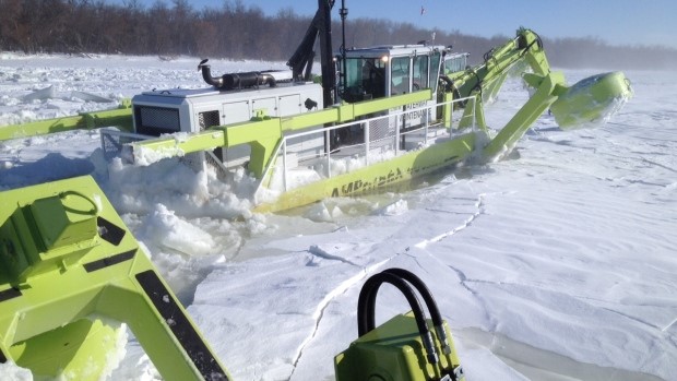
Figure 8 Amphibex dredge-excavator and ice breaking machine at work in Manitoba, breaking up River ice to reduce potential for ice jams and flooding. Source: CBC
Climate change impacts on river ice processes
For much of Alberta, river ice is a reality that must be managed to minimize risk to people and infrastructure. There are many examples of naturally occurring phenomenon that, like ice jams, create risks that must be mitigated on an ongoing basis. Other severe weather events like flooding, drought, hailstorms, etc. are natural ecosystem functions, but can pose a risk to human health and safety. These are natural fluctuations in our natural system that are simply part of life in Alberta, to which we have adapted to the best of our abilities. However, the climate is changing and the variability of these systems is expected to increase, resulting in more frequent and harder to predict extreme severe weather events. Read more about climate change and variability here. It is difficult to predict what the effects of climate change will be on river ice processes (and subsequently ice jams) for each river in Alberta, but we can connect some of the ice processes with shifting weather patterns predicted as a result of climate change.
Ice jams are only one part of the river ice formation process, which is governed by many factors like streamflow, ice thickness and strength, and stream morphology. These factors may in turn, be influenced by surrounding weather conditions or previous extreme weather events (impacting the river channel or surrounding landscape). For instance, rising temperatures with a changing climate are predicted to reduce the ice season duration by 2-4 weeks in the Peace River basin. Ice cover is predicted to be thinner than it is today, and the frequency of mid-winter thaws is predicted to increase. These thaws are expected to reduce snowpack in the region and, in combination with the shifts in ice cover, are predicted to reduce the frequency of ice jam flooding (Beltaos et al., 2008). Many river basins predict a shift in the timing and magnitude of peak streamflow, which are an important factor in determining whether a particular ice jam will lead to a flooding event or not (Beltaos & Prowse, 2001). Large differences exist between the many places that experience ice jams in terms of all processes leading to ice formation and ice jam flooding, such as geography, climate, land use, etc. Understanding these processes at a local and regional scale will be critical for mitigating potential impacts of climate change and adapting to the changes in river ice processes.
References
Beltaos, S., Prowse, T., Bonsal, B., Carter, T., MacKay, R., Romolo, L., … Toth, B. (2008). Climate Impacts on Ice-jam Floods in a Regulated Northern River. In M. Woo (Ed.), Cold Region Atmospheric and Hydrologic Studies. The Mackenzie GEWEX Experience: Volume 2: Hydrologic Processes (pp. 345–361). Berlin, Heidelberg: Springer Berlin Heidelberg. https://doi.org/10.1007/978-3-540-75136-6_18
Beltaos, S., & Prowse, T. D. (2001). Climate impacts on extreme ice-jam events in Canadian rivers. Hydrological Sciences Journal, 46(1), 157–181. https://doi.org/10.1080/02626660109492807
Burrell, B. C., Huokuna, M., Beltaos, S., Kovachis, N., Turcotte, B., & Jasek, M. (2015). Flood Hazard and Risk Delineation of Ice-Related Floods : Present Status and Outlook. Proceedings – 18th Workshop on the Hydraulics of Ice Covered Rivers, Quebec City, CGU-HS CRIPE.
Cairny, R. (2015). Cool research projects probe river ice life cycle – University of Alberta. Retrieved February 28, 2017, from http://research.engineering.ualberta.ca/en/ResearchNews/2015/June/Coolresearchprojectsproberivericelifecycle.aspx
Carr, M., Gaughan, S., George, C., & Mason, J. (2015). CRREL’s Ice Jam Database: Improvements and Updates Meredith. Proceedings – 18th Workshop on the Hydraulics of Ice Covered Rivers, Quebec City, CGU- HS CRIPE.
Parmley, L., Mark, H., Doyle, P., Raban, R., Fonseca, F., Robert, S., & Wigle, T. (1990). Optimum operation of hydro-electric plants during the ice regime of rivers: a Canadian experience. Associate Committee on Hydrology Subcommittee on Hydraulics of Ice Covered Rivers.
Public Safety Canada. (2013). Canadian Disaster Database. Accessed 4 April 2017 from: http://cdd.publicsafety.gc.ca