What is a 1-100 Year Flood?
In flood hazard mapping, some areas are indicated as being at risk for a 1-100 year flood. Flood mapping is used to illustrate risk in certain areas to allow municipalities and communities to plan for the possibility of flooding.
Frequently the meaning of 1-100 year flood is misinterpreted as meaning a flood will occur in the highlighted area only once every 100 years. 1-100 year is actually a statistical designation meaning that in any given year there is a 1% chance a flood risk area will flood. It is similar to rolling a 100 sided dice each year where the number “1” means the area will flood. Further, some areas have experienced more than one 1-100 year flood in the same year.
|
Recurrence interval in years |
Probability of occurrence in any given year |
Percent chance occurrence in any given year |
The same as rolling a 1 on a ____ sided dice. |
|
250 |
1-250 |
0.4% |
250 |
|
100 |
1-100 |
1% |
100 |
|
50 |
1-50 |
2% |
50 |
|
40 |
1-40 |
2.5% |
40 |
|
10 |
1-10 |
10% |
10 |
|
6 |
1-6 |
16.7% |
6 |
Multiple 1-100 Year Floods In Less Than 100 Years
Every year there is a risk that the flood hazard area may experience a flood. These areas might not be affected by floods for decades, while some decades may see multiple floods or even more than one flood in a year. So why do multiple 1-100 year floods happen in short timespan? Sometimes the unlikely happens and the 100 sided dice rolls a 1 twice in a row. Other times it’s due to human influence on the watershed, or an initial assessment that did not have enough data.
Unlikely is Possible; and Increased Time, Increased Risk
The amount of time spent in an area identified as being at risk for flooding increases the likelihood of being impacted by a flood. The following table illustrates the likelihood of an identified area being affected by at least one flood over various periods of time.
|
Years |
Likelihood of a flood |
||
|
1-50 (2%) |
1-100 (1%) |
1-250 (0.4%) |
|
|
10 |
18.3% |
9.6% |
3.9% |
|
30 |
45.5% |
26.0% |
11.3% |
|
50 |
63.6% |
39.5% |
18.2% |
|
70 |
75.7% |
50.5% |
24.5% |
|
100 |
86.7% |
63.4% |
33.0% |
|
130 |
92.8% |
72.9% |
40.6% |
|
150 |
95.2% |
77.9% |
45.2% |
|
250 |
99.4% |
91.9% |
63.3% |
Changes to the Watershed
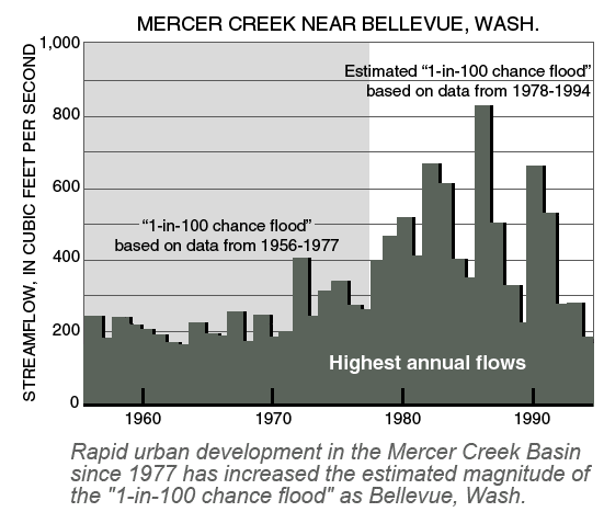
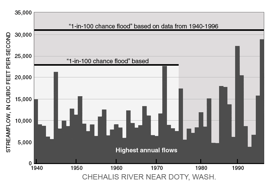
Historical records of river activity are often used to calculate the 1-100 year; however, changes to the river and riparian areas over time may influence present day river activity. A river that has had one or more dams installed, several kilometers of wetlands and riparian areas removed, or rapid urbanization will behave differently. It is possible that there is now a systematic error in the calculation vs modern day events. Figure 1 demonstrates the new designation given as more data is collected and re-evaluated by scientists.
|
|
Increased urban development in the Mercer Creek Basin increased the streamflow and therefore changed the data to be considered.[1] |
New Information and Additional Data
If the historical data being used happens to represent a period where there was lower or higher number of floods than normal, then by random chance the initial calculation is incorrect.
|
|
New data over time changed the expected magnitude of a 1-100 year flood in the Chehalis River. [2] |
[1] Dinicola, Karen. (2014). The “1OO-Year Flood”. U.S. Geological Survey. Retrieved fromhttp://pubs.usgs.gov/fs/FS-229-96/