Drought Forecasting and Monitoring
What it drought forecasting and monitoring and how does it work?
Drought forecasting and monitoring can be defined as data collection, analysis, and reporting to develop information on current and future drought conditions [1][2]. Observing and understanding current and historical weather, soil, and hydrologic conditions during droughts goes hand-in-hand with predicting future droughts, as these observations are the main inputs for computer models used in drought forecasting [3].
Drought reports derived from monitoring data and forecasts simulated in computer models typically report drought in terms of the extent, severity, and duration of drought conditions [4] [5]. There is not a universally accepted way of measuring/forecasting drought; however the various measures used to create maps are largely calculated from temperature, precipitation, streamflow, and soil moisture data [6]. Canada’s official drought reports (Canadian Drought Monitor, CDM) rely on multiple calculations and datasets, including satellite imagery and well-established indices, such as the Palmer Drought Severity Index (PDSI) and the Standardized Precipitation Index (SPI) [6]. The CDM is a map of current drought conditions while forecasts use the same calculations and include future inputs.
Why are drought forecasting and monitoring important mitigation methods?
Farmers are some of the people most directly impacted by drought and regularly cite having access to seasonal forecasts of the climate as one of their most important tools for making important decisions regarding the management of their crops, livestock, soil, harvest, and equipment [7]. Those responsible for controlling and protecting water bodies – including groundwater and wetlands – rely on drought reports and forecasts in order to adjust their operations, trigger water use restrictions, and shift allocations. Water users and water treatment operators require drought forecasts to respond appropriately to elevated water temperatures and changes to biochemical processes that occur under low moisture conditions.
 |
|
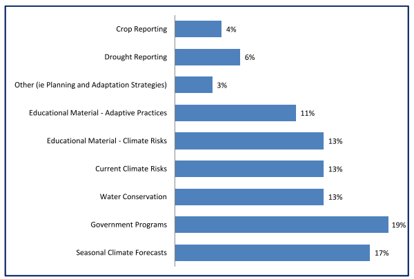
Caption: Types of information preferred by water users in the Yorkton Creek sub-basin in Saskatchewan from Rowan et al. (2011). Seasonal Climate Forecasts were the consistently highest or second-highest ranked form of information for all user groups (farmers, water managers, municipal decision makers, community organizations [7]. |
What drought forecasts and monitoring programs cover Alberta?
The main programs presenting both current and future drought conditions for Alberta include:
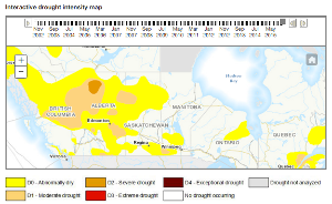
Canadian Drought Monitor: Map of current conditions, produced by Agriculture and Agri-food Canada.
Moisture Situation Updates: Frequent (weekly to monthly) report and mapping on current agricultural moisture across Alberta, with occasion reporting on future conditions.
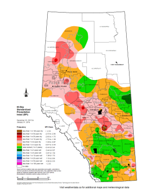
Drought – Alberta Climate and Atlas Maps: Maps of the Standardized Precipitation Index (SPI) over Alberta.
Water Supply Outlook for Alberta: Description of future conditions of streamflow, produced by the Alberta Government.
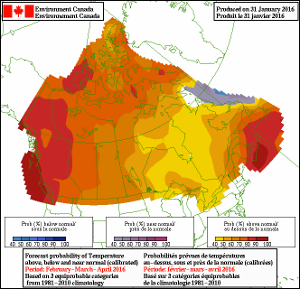
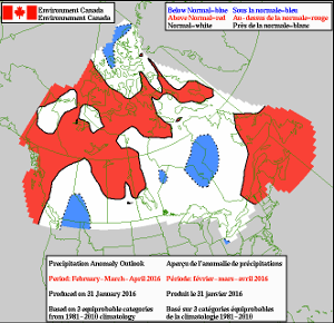
Seasonal Temperature and Precipitation Forecasts: Maps of future conditions (0.5-12.5 months), produced by Environment and Climate Change Canada, and the U.S. National Oceanic and Atmospheric Administration
|
Seasonal Forecasts from ECCC |
Drought Severity Map from CDM |
  |  |
|
SPI Maps from Alberta Climate and Atlas Maps |
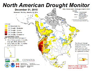
Drought Severity Map from NADM |
 |  |
List of programs last updated: February 2016.
What levels of government are responsible for drought monitoring and forecasting?
The federal government, through Environment and Climate Change Canada and Agriculture and Agri-Food Canada, and Government of Alberta’s AgroClimatic Information Service (ACIS) all provide products related to drought forecasting. The Canadian Drought Monitor (CDM) is Canada’s official source of monitoring and reporting on current drought conditions. The monthly assessments produced through the CDM are compiled with similar data from the U.S. and Mexico to produce the North American Drought Monitor – a picture of continental drought.
At the provincial scale, the ACIS provides more detailed information on drought conditions across Alberta through monthly Agricultural Moisture Situation Updates and Water Supply Outlook for Alberta.
What are the challenges in drought forecasting?
Drought arises from a highly complicated set of interactions between the earth’s surface and the atmosphere, making the accurate prediction of future occurrences of drought challenging. Even for current conditions accurately mapping drought can be a challenge. Some of the major scientific challenges for forecasting drought with high degrees of accuracy include:
- Limitations in the ability of computer models to predict the exact location, timing and spatial extent of air masses and their movement,
- The role of large-scale teleconnections such as the El Niño/Southern Oscillation and the Pacific Decadal Oscillation,
- Understanding the interactions between multiple variables and scales of weather patterns, and
- Determining the best way of calculating measures of drought severity [3] [5] [6].
Forecasting climate change has also added a new layer of complexity to drought forecasting. The occurrence and severity of droughts are projected to increase with climate change however it is difficult to plot this with accuracy [8].
Despite these challenges, drought forecasts and monitoring information are critical tools for water managers and communities. The science of drought prediction is constantly evolving along with similar advances in flood forecasting. As these information tools improve, so too will the effectiveness of the mitigation of climate and severe weather events. Improved drought forecasting can enhance the ability of water managers and communities to prepare for extreme events before they occur.
Sources
[1] Alberta Agriculture and Forestry. 2014. Drought Monitoring and Reporting. Available online: http://www1.agric.gov.ab.ca/$Department/deptdocs.nsf/all/ppe9019
[2] Adapted from: Sheffield, J., Wood, E. F., Chaney, N., Guan, K., Sadri, S., Yuan, X., … Ogallo, L. (2014). A drought monitoring and forecasting system for sub-sahara african water resources and food security. Bulletin of the American Meteorological Society, 95(6), 861–882. http://doi.org/10.1175/BAMS-D-12-00124.1
[3] National Drought Mitigation Center, University of Nebraska Lincoln. N.D. Predicting Drought. Available online: http://drought.unl.edu/DroughtBasics/PredictingDrought.aspx
[4] Vicente-Serrano, S. M., Beguería, S., Lorenzo-Lacruz, J., Camarero, J. J., López-Moreno, J. I., Azorin-Molina, C., … Sanchez-Lorenzo, A. (2012). Performance of Drought Indices for Ecological, Agricultural, and Hydrological Applications. Earth Interactions, 16(10), 1–27. http://doi.org/10.1175/2012EI000434.1
[5] Madadgar, S., & Moradkhani, H. (2013). Drought Analysis under Climate Change Using Copula. Journal of Hydrologic Engineering, 18(7), 746–759. http://doi.org/10.1061/(ASCE)HE.1943-5584
[6] Agriculture and Agri-Food Canada. 2015. About the Canadian Drought Monitor. Available online: http://www.agr.gc.ca/eng/?id=1433796848570
[7] Rowan, K., Pittman, J., Wittrock, V., Hershmiller, A., & Nielsen, J. (2011). Assiniboine Watershed Stewardship Association Drought and Excessive Moisture Preparedness Plan. Assiniboine Watershed Stewardship Association, Natural Resources Canada and Saskatchewan Watershed Authority.
[8] Mishra, A. K., and Singh, V. P. (2011). Drought modeling–A review. Journal of Hydrology, 403(1), 157-175.