Why we plan around watersheds
by Jeff Wiehler from the Land Use Planning Hub
A land use plan is a blueprint for the future. It sets out goals for a specific region and then identify what activities, uses or development best fit in the goals. There are two key parts of land use planning:
- What area or region will be covered by the plan
- The goals and uses applicable to that region
The challenges of land use planning typically fall to the second aspect: what set of regulations best reflect the environmental, social and economic goals of a region? How can competing uses or values be considered? These questions are the essence of the difficulty of land use planning, so they tend to be the priority when creating and following land use plans.
But back to the first key part: how are the borders decided for land use plans?
In Alberta’s broadest land use plans, watersheds are used to define the regions.
Alberta’s Land-use Framework defined seven regional planning areas that combine to cover the entire province. The Framework was released in 2008 and since then two regional plans have been created. The regional plans outline the goals for the regions and creates a set of guiding principles that planning documents – such as municipal development and intermunicipal development plans – must adhere to. The seven regions within the Land-use Framework divide the province according to watersheds.
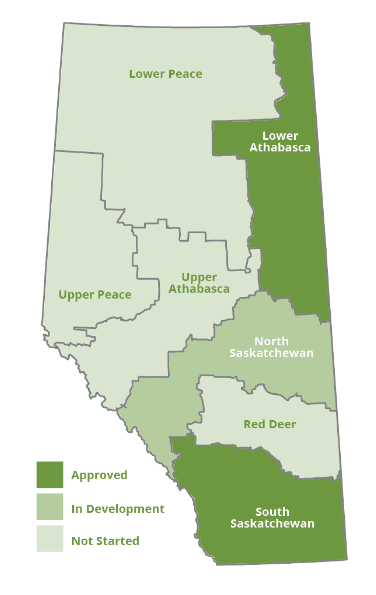
Map of the seven regions and status of regional plan development for each. Image source: Land Use Planning Hub, https://landusehub.ca/resources/.
Watersheds are one spatial scale that is used to create the geographical scope of land use plans. Here’s a dive into why watersheds are used to create boundaries.
Watersheds are an ecosystem proxy
Watersheds are a type of spatial boundary based on ecological systems. A researcher in rural sociology from Missouri explored why watersheds have become an “ecosystem proxy” for land use decision makers in a research paper, Ecological Boundaries as Community Boundaries: The Politics of Watersheds. Watersheds are the most common form of ecological boundaries used by governments in their land use planning.
“Watersheds, defined by the ridgetops that separate drainage basins from one another, provide ecosystem boundaries that are not as open to dispute in terms of their physical location. This choice also reflects the recognition that water is critical to all life forms, as well as to human forms of economic production such as agriculture and industry,” reads the 2001 research paper by Elizabeth Barham.
Watersheds have relatively discrete boundaries and are a tangible step towards landscape level planning, integrated planning or holistic approaches.
With definable borders, watersheds are a compromise between the need to plan around distinct regions and a modern understanding of the interconnectedness of natural systems.
This balance is an opportunity and challenge:
“Watershed thinking can be an opportunity to strengthen our ability to work together, or it can represent the imposition of new authority that ultimately undermines collective decision making.”
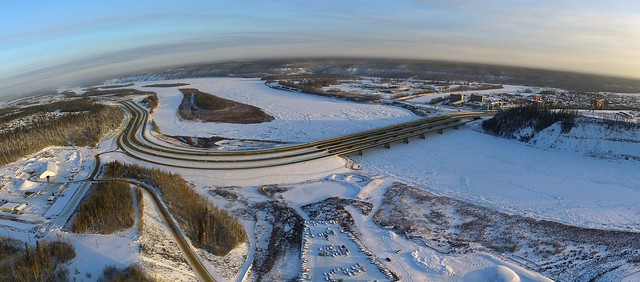
Athabasca River – The first regional plan under the Land-use Framework was for the Lower Athabasca region, which includes the downstream half of the Athabasca River watershed. Image source: miguelb, Flickr; Creative Commons BY 2.0
Balance between landscape and local levels
The Land-use Framework divides the province according to the watersheds. Insights into this approach come from feedback from working groups that provided advice on the development of the Land-use Framework. The Planning and Decision-Making Working Group collected the input from citizens, government authorities and landowners on how the Land-use Framework will be implemented.
The working group offered the following insights in the Multi-stakeholder Working Groups Roll-up Report for defining regions:
- Regions should be at the landscape level so they don’t interfere with local land-use decision-making processes.
- Regions should consider and avoid splitting natural landscape zones, watersheds, ecological zones, natural regions, Treaty areas and municipal boundaries.
- Watersheds have already been used as regions in the Water for Life strategy and in the Public Lands Act.
- Splitting administrative regions (such as municipalities or Forest Management Agreement boundaries) is not ideal.
Watersheds fit the criteria of regions that are broad but not too broad. Here is the justification from the final Land-use Framework:
“The Land-use Framework creates seven regions for Alberta based on the major watersheds, with boundaries aligned to best fit with existing municipal boundaries and
the natural regions. These regions are large enough to work at the landscape level. However, the delineation of boundaries recognizes that not all important issues are completely addressed at one spatial scale. Where there are issues that cross regional boundaries, the need for linkages and compatible treatment will be identified in the relevant plans.”
For more information about the province’s regional plans, here is a history of regional planning in Alberta.
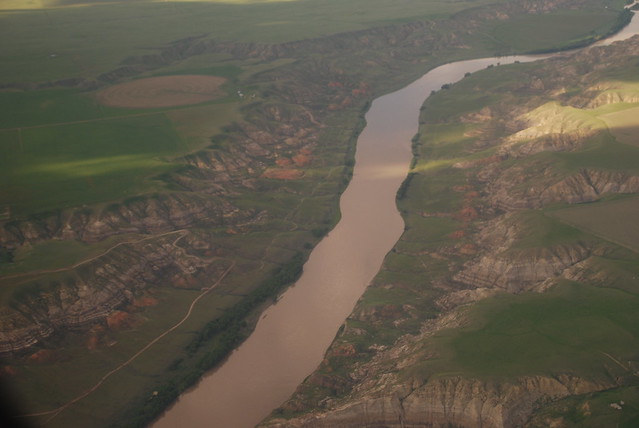
South Saskatchewan River – South Saskatchewan River nearby Medicine Hat, Alberta. The second regional plan to be implemented in Alberta covered the South Saskatchewan watershed. Image source: Paul Jerry, Flickr; Creative Commons BY 2.0
A start to cumulative effects management
The Land-use Framework prioritizes cumulative effects management, another reason to use an ecological area as the basis for the administrative regions within the Framework.
Cumulative effects are the environmental impacts from all activities – past and present. It considers how different activities or development can make environmental impacts worse, better or completely different than expected.
The Land-use Framework identified this approach as a step away from the norm:
“Alberta’s system for assessing the environmental impacts of new developments has usually been done on a project-by-project basis. This approach worked at lower levels of development activity. However, it did not address the combined or cumulative effects of multiple developments taking place over time.”
By considering the impacts on an ecological scale, Alberta’s regional plans can begin to integrate cumulative effects management into land use decisions.
Watershed integrity a priority
The Land-use Framework is the latest iteration of regional planning in Alberta, but it is not the only example. To provide direction for resource and land use in the region extending from the Rocky Mountains to the foothills, the Eastern Slopes Policy was introduced in 1977. The Land-use Framework acknowledged the Eastern Slopes Policy as an important influence on the current approach to land use planning.
“The Eastern Slopes Policy identified watershed integrity as the highest priority use for this region of the province, followed by public recreation and tourism. It stated that the management of renewable resources would be the priority, but that non-renewable resource development—primarily oil and gas—would be encouraged in areas where it was compatible,” reads the Land-use Framework.
To protect vital headwaters, the Eastern Slopes Policy outlined the following objectives to the management of the region:
- Manage and develop natural resources to maintain or increase volume of water.
- Manage headwaters to maintain recharge and protect fish habitat.
- Manage water supply for South Saskatchewan River basin.
- Maintain natural flows in the North Saskatchewan River and Athabasca River basins.
Using watersheds as the boundary for regional plans is an approach to prioritizing watershed integrity in land use decisions.
Going beyond watersheds
Watersheds are used as a boundary for regional plans because they are an ecological proxy and a balance between broad and not too broad. It moves collective decision making outside jurisdictional borders. Continuing to transition beyond traditional boundaries for land use decisions can provide opportunities for improved cumulative effects management and environmental protection.
– – – – –
About the Land Use Planning Hub
The Land Use Planning Hub is an informal network that supports the implementation of Alberta’s regional plans by sharing information, stories and feedback. Land use practitioners and planners from around Alberta can share information, stories and feedback related to land use planning.
The website was created and is managed by fRI Research with support from the Land Use Secretariat. It is a complement to the existing Land-use Knowledge Network.
Sources
A Policy for Resource Management of the Eastern Slopes, Revised 1984, Government of Alberta (1984): https://open.alberta.ca/dataset/63df0041-7619-4fc9-948b-738cf108e47c/resource/6938bfdd-1316-4f84-adf7-5ed1744b3d84/download/1984-policyresourcemanagementeasternslopes.pdf
Barham, Elizabeth, Ecological Boundaries as Community Boundaries: The Politics of Watersheds, Society & Natural Resources, Volume 14, Issue 3 (2001): https://www.tandfonline.com/doi/pdf/10.1080/08941920119376
Land-use Framework, Government of Alberta (2008): https://landuse.alberta.ca/LandUse%20Documents/Land-use%20Framework%20-%202008-12.pdf
Land-use Framework Multi-Stakeholder Working Groups Roll-up Report, Government of Alberta (2007): https://open.alberta.ca/dataset/b2a46195-5ab9-4ed2-b77f-9b5b280a7813/resource/17a15ea2-c536-4990-aa09-c3a47837069d/download/multi-stakeholder-working-groups-report-overview-2007-11.pdf
The Boom and Bust of Regional Planning, Land Use Planning Hub (2018): https://landusehub.ca/the-boom-and-bust-of-regional-planning/