Flood Forecasting Review and Workshop Conclusions
Two reports have been released from AI-EES and Alberta WaterSMART, one with conclusions from the February Workshop and another which compares the Alberta Flood Forecast system to other jurisdictions from across Canada and the globe. These reports focus on flood forecasting rather than flood mitigation, and are a follow up to a workshop we live tweeted back in February. As always, if you have feedback we will send it on to the authors.
Having attended the workshop, the following would be the top three most interesting things (to the author) mentioned at the workshop.
1. Data Collection – Community Collaborative Rain, Hail & Snow Network (CoCoRahs)
One problem that plagues flood forecasting is a lack of data, however that may change with enough citizen involvement. CoCoRahs is a volunteer program where individuals measure the rain at their home every day and submit information to a database thereby expanding the available data. This database can then be used by Flood Forecasters, Researchers, Modellers, or whoever is just curious to view the data or calibrate models. CoCoRaHs is a popular tool used in the U.S. that allows citizens to provide rainfall data to flood forecasting specialists. Specifically, Colorado used CoCoRaHs as an additional tool for acquiring precipitation data to determine water quantities during their 2013 flood. If you’re interested in contributing, visit the CoCoRahs website for more information. Data collected from southern basins Alberta will be used put to good use. The data submitted from southern Alberta basins eventually feed into the Manitoba River Forecast Centre which uses CoCoRahs in their forecasting systems.
2. Communication Systems – Scottish Environment Protection Agency’s (SEPA) FloodLine
For those living in flood hazard areas in Scotland and the UK, there is a voluntary flood warning system called FloodLine. In this system, an individual may register to receive a call or text to their phone if a flood warning, alert, or severe warning is issued for their area. It’s an automated system so individuals may also phone in for further information. This communication model is advantageous in that it can be used by people without smartphones and provides location specific information to each user. FloodLine is an extremely popular communication tool used by SEPA to get warnings and information out to the public. Furthermore, the public actively uses FloodLine to gain relevant information for their area. Going forward, it will be interesting to compare the FloodLine system with the forthcoming Alberta River Forecast Centre app.
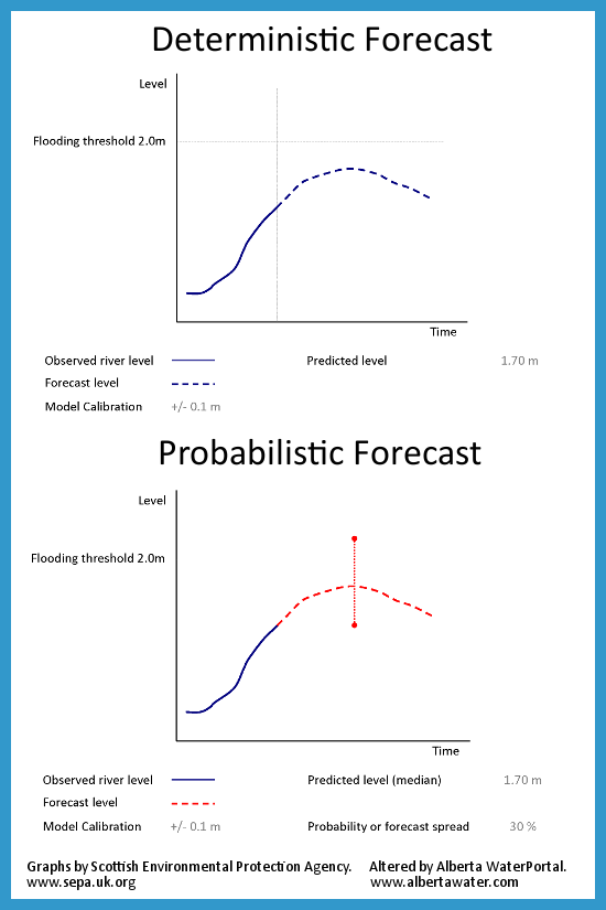
3. Expressing Risk – Probabilistic Forecasting vs Deterministic Forecasting
In Alberta, the River Forecast Centre releases Deterministic Forecasts. This means that the forecast specifically gives you one answer (e.g. High Stream Flow Advisory in effect) instead of a range of possibilities. Probabilistic forecasting would provide a range for the expected flows. Given that Albertans are used to a range of possibility in our forecast, (e.g. High of 15C, low of 3C) it’s possible that a more variable forecast could be used in flood forecasting.
A summary of the first day of the workshop may be viewed in our blog. Below is a summary of the second day.