Where’s the “Good” Water?
Where’s the “Good” Water?
In Alberta, non-saline water is defined under the current Water Act as any water that possesses a mineralization (as total dissolved solids content, or TDS, in mg/L) equal to or less than 4,000 mg/L. This water can reside in unconsolidated or consolidated bedrock formations situated anywhere from surface to depths exceeding several hundreds of meters.
The interface that demarks the change from 4,000 mg/L TDS to greater values is commonly referred to as the Base of Groundwater Protection (BGP). Considerable work has been done by the province of Alberta (Alberta Geological Survey) to define where and at what depth this interface exists. This is the depth that any industry can have an effect on non-saline groundwater which is why mitigation is required to ensure such events don’t occur. The mitigation, commonly employed by industry, is to provide a steel casing and cement seal from the surface to the BGP.
Alluvial Aquifers
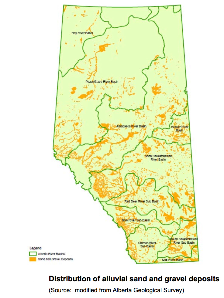
Alluvial aquifers in the province of Alberta comprise the unconsolidated sand and gravel deposits that we commonly see along existing river beds, the occasional road cut or sometimes in an excavated gravel pit. These granular deposits tend to possess very high permeability due to the presence of significant void space between the sand, gravel and silt grains. As such, these deposits can yield significant quantities of water and because these deposits are close to surface, the water quality tends to be quite fresh.
The majority of these deposits represent recent (within the last few thousand years) sediments deposited by water flowing across the landscape along relatively well-defined drainage ways. In some cases, these deposits have been buried under layers of sediment that were deposited by glaciers that advanced and retreated across the Alberta landscape during the most recent continental glaciations, which ended some 10,000 to 15,000 years ago.
The diagram (right) shows the distribution of major sand and gravel deposits across the province of Alberta. It is evident that some areas of the province benefit from substantial accumulations of these materials, and in turn the potential to develop groundwater resources if needed. Because these deposits reside close to the surface, costs of developing groundwater from these intervals is greatly reduced.
Some concern is mounting with respect to the mining of these alluvial sand and gravel deposits for aggregate materials to support construction activities. Mining of the aggregate material from its natural resting place requires dewatering of the sediments, which can lead to adverse effects to nearby users or sensitive ecological receptors and groundwater dependant ecosystems. Removal of this material also diminishes the water storage capacity and can disrupt subsurface flow systems. Consideration of these effects is therefore needed when developing groundwater resources from alluvial aquifers.
From a groundwater quality perspective, alluvial aquifers are the most sensitive type of aquifer to influences on the landscape. Depending on the type, extent and thickness of sediments covering these aquifers, the application or spills of chemicals and leaking of septic systems can significantly affect the quality of groundwater over localized areas, sometimes referred to as point-sources, or very broad areas (non-point sources).
Buried Channel Aquifers
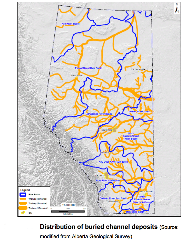
Lying beneath the surface of our province is an intricate network of buried channels formed prior to the last continental glaciations of North America (the ancestral drainage network) or formed during the process of erosion by glacial melt-water formed during warmer periods.
During the last continental glaciation, up to four episodes of ice advance and retreat occurred in response to the varying climatic conditions. During each of these events, deposits of sand and gravel were laid down in various locations across the province as broad outwash plains, fluvial channels and lacustrine (lake) deposits. These porous and permeable intervals were then subsequently buried under less permeable deposits of till, thus forming confined aquifers. The depositional features of interest here are the buried channels, which host considerable quantities of water in the pore spaces of the sand and gravel deposits.
The known network of buried channels beneath our province is shown in the diagram (right). As indicated, the network is extensive across the Alberta plains area east of the foothills area (or deformed belt) of the Rocky Mountains.
The morphology and overall sediment compositions within each buried channel varies. Within each of these features resides quantities of groundwater that can be used to supply rural populations and associated economic activities including rearing of livestock, cropping, mining and oil and gas recovery. Some of these buried channels are currently accessed as supply sources to support such activities.
Bedrock Aquifers
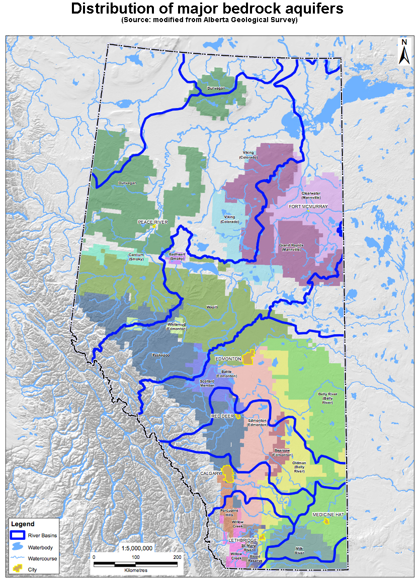
In addition to the vast accumulations of granular sediments comprising alluvial aquifers and buried channel deposits, a number of bedrock formations possess water-bearing properties and contain significant quantities of useable groundwater (Figure 13). These bedrock formations tend to be comprised of thick alternating sequences of sandstone, siltstone and shale deposited in the foreland basin of the Western Canadian Sedimentary Basin over the last 100 million years (i.e., Cretaceous to Tertiary Periods).
There are a number of bedrock aquifers that are currently being utilized in Alberta. Learn more about each formation according to approximate age, origin and dominant lithology (physical characteristics).
The most significantly used bedrock formation containing useable quantities of non-saline groundwater is the Paskapoo Formation of more recent age. An estimated 200,000 wells have been drilled into this southern Alberta formation, with about 70,000 considered active (GoA 2010). By international standards, the Paskapoo Formation would not be considered a “classic aquifer system” as the yield capability is restricted by its dominant fine-grained lithology and highly variable spatial-character with respect to sandier and more permeable intervals.
A modern day analogue of the type of depositional environment responsible for such a formation exists in the Columbia Valley of the East Kootenays. There, the Columbia River winds its way from the headwaters of Columbia Lake northward towards Golden through a series of wetlands, depositing granular materials within distinct channels in stacked sequence or as over-bank deposits of limited extent. As such, the low energy depositional environment is prone to the accumulation of fine-grained sediments (silt and clay) which interrupt otherwise continuous and connected sandy intervals.
The other bedrock aquifers of Cretaceous age do supply, or have the potential to supply, large quantities of usable groundwater but are more prone to highly mineralized porewater due to interaction with higher salinity formations deposited in the Cretaceous sea that extended across Alberta at the time. Nevertheless, in areas where these bedrock formations come close to the surface, many residents and businesses in Alberta access the water supplies contained within for personal or economic use.
Section 2: Alberta’s Water Balance and Inventory
Module 1: What do we know about groundwater today?
Module 2: How important is groundwater to Albertans?
Module 3: How much groundwater is there?
Module 4: Where’s the “good” water?
Module 5: What about the saline water?