St. Mary River Irrigation District: Projects Overview
St. Mary River Irrigation District
The following is a complete list of all projects included in the St. Mary River Irrigation District (SMRID) under this program. There are 25 pipeline modernization projects, one structure rehabilitation and one reservoir project.
Pipeline Projects
All pipeline modernization projects are scheduled for completion by 2024/2025. The proposed schedule of projects is detailed in tables 1-4 below. Approximately 160 kilometres of canal will be replaced with buried PVC pipelines, which will result in significant water savings and efficiency gains through reduced seepage, evaporation and the elimination of tail-out losses. Approximately 57500 acres of farmland are served by these systems.
PVC pipelines have an expected lifespan in excess of 80 years, and the assets will be incorporated into the District’s long-term Asset Management plan.
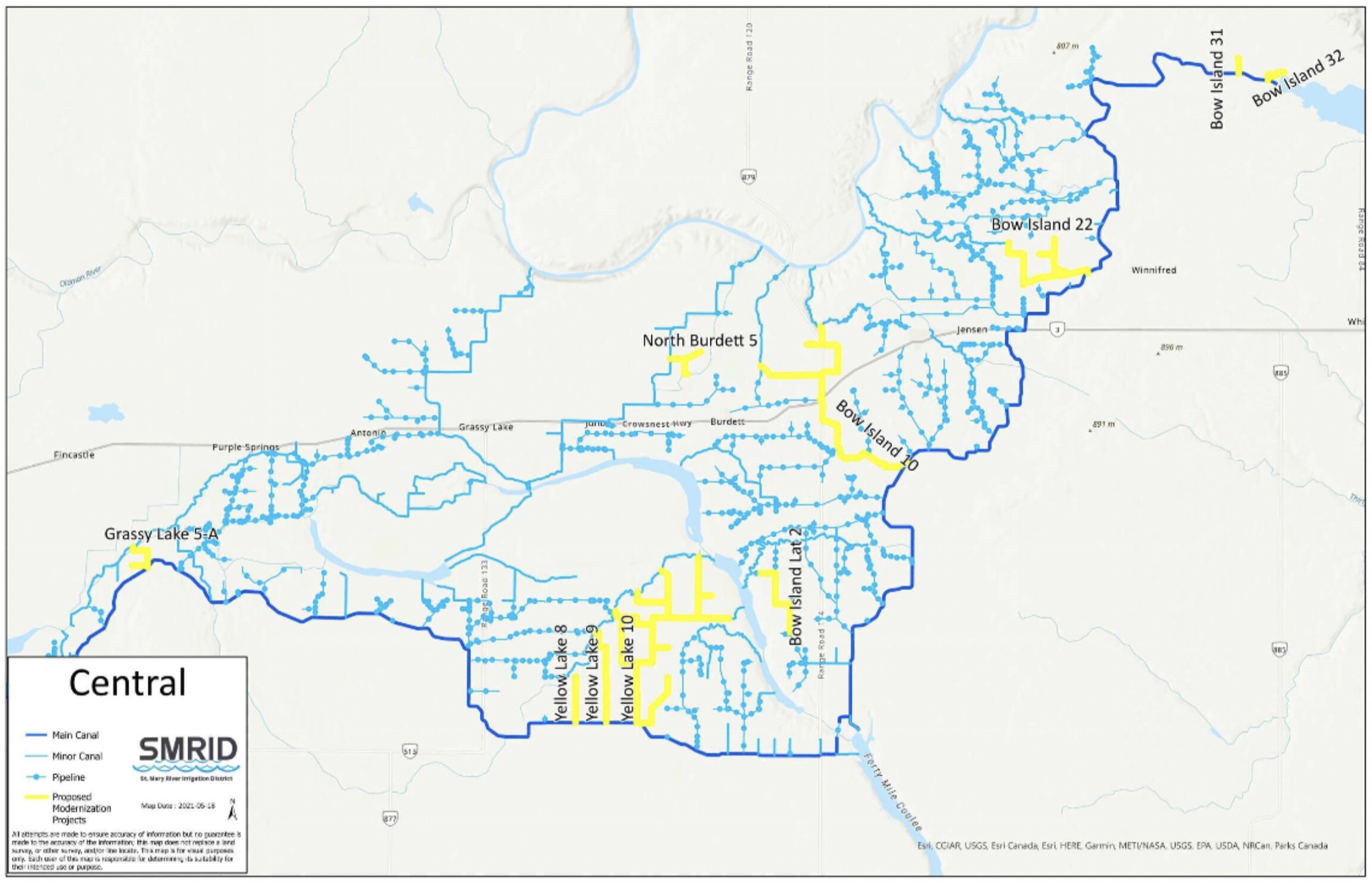
The projects are phased over five years from 2020/2021 to 2024/2025, with projects grouped by area (West SMRID, Middle and East).
Accounting for evaporation and seepage, it is estimated that the district will save on average 40000 acre-feet per year from these projects.
Table 1. 2020/2021 Modernization Projects
| Project Name | Project Description | Cost Estimate |
| Eight Mile Lateral | Pipeline | $3,100,000 |
Table 2. 2021/2022 Modernization Projects
| Project Name | Project Description | Cost Estimate |
| Cameron Lateral Pipeline phase 5 | Pipeline | $7,000,000 |
| Sauder Chute Replacement | Structure Rehabilitation | $13,000,000 |
| West Medicine Hat Lateral 2, phase 1 | Pipeline | $9,250,000 |
| Whoop-Up Lateral | Pipeline | $5,850,000 |
| Main Canal 7 | Pipeline | $2,340,000 |
| Jail Road Lateral | Pipeline | $3,276,000 |
| Sauder Reservoir Lateral 34 | Pipeline | $4,170,000 |
| South Medicine Hat Lateral 3 | Pipeline | $5,850,000 |
| West Medicine Hat Lateral 31 | Pipeline | $5,525,000 |
| West Medicine Hat Lateral 38 | Pipeline | $2,600,000 |
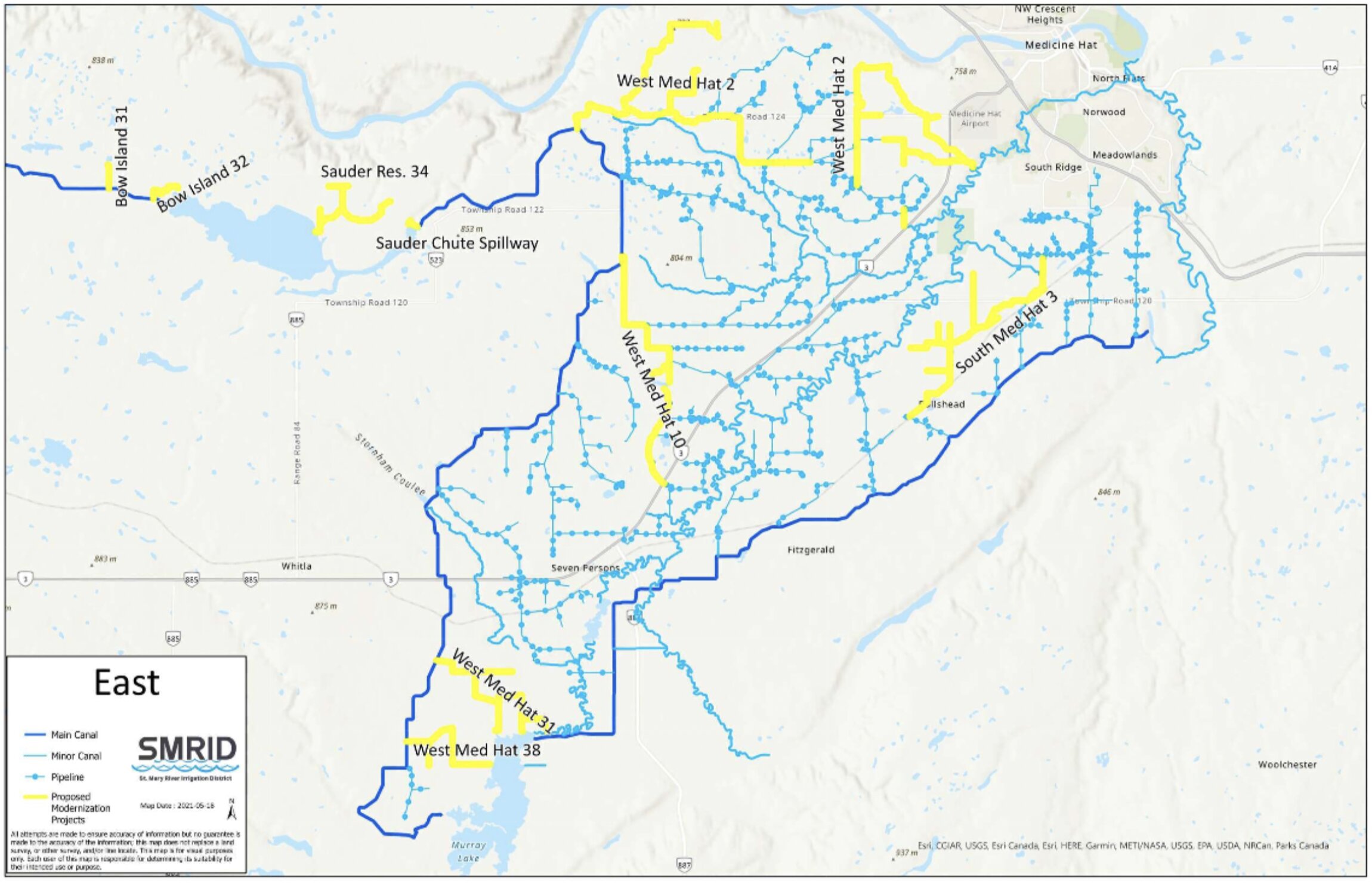
Table 3. 2022/2023 Modernization Projects
| Project Name | Project Description | Cost Estimate |
| North Lateral – Baczuk | Pipeline | $1,950,000 |
| Chin 2-2 | Pipeline | $1,950,000 |
| Chin 4/Chin 5 | Pipeline | $5,148,000 |
| Chin 2 – Ext 1 | Pipeline | $650,000 |
| West Medicine Hat 2, phase 2 | Pipeline | $9,250,000 |
| North Burdett Lateral 5 | Pipeline | $2,340,000 |
| Bow Island Lateral 10, phase 1 | Pipeline | $9,828,000 |
| Bow Island Lateral 22 | Pipeline | $5,525,000 |
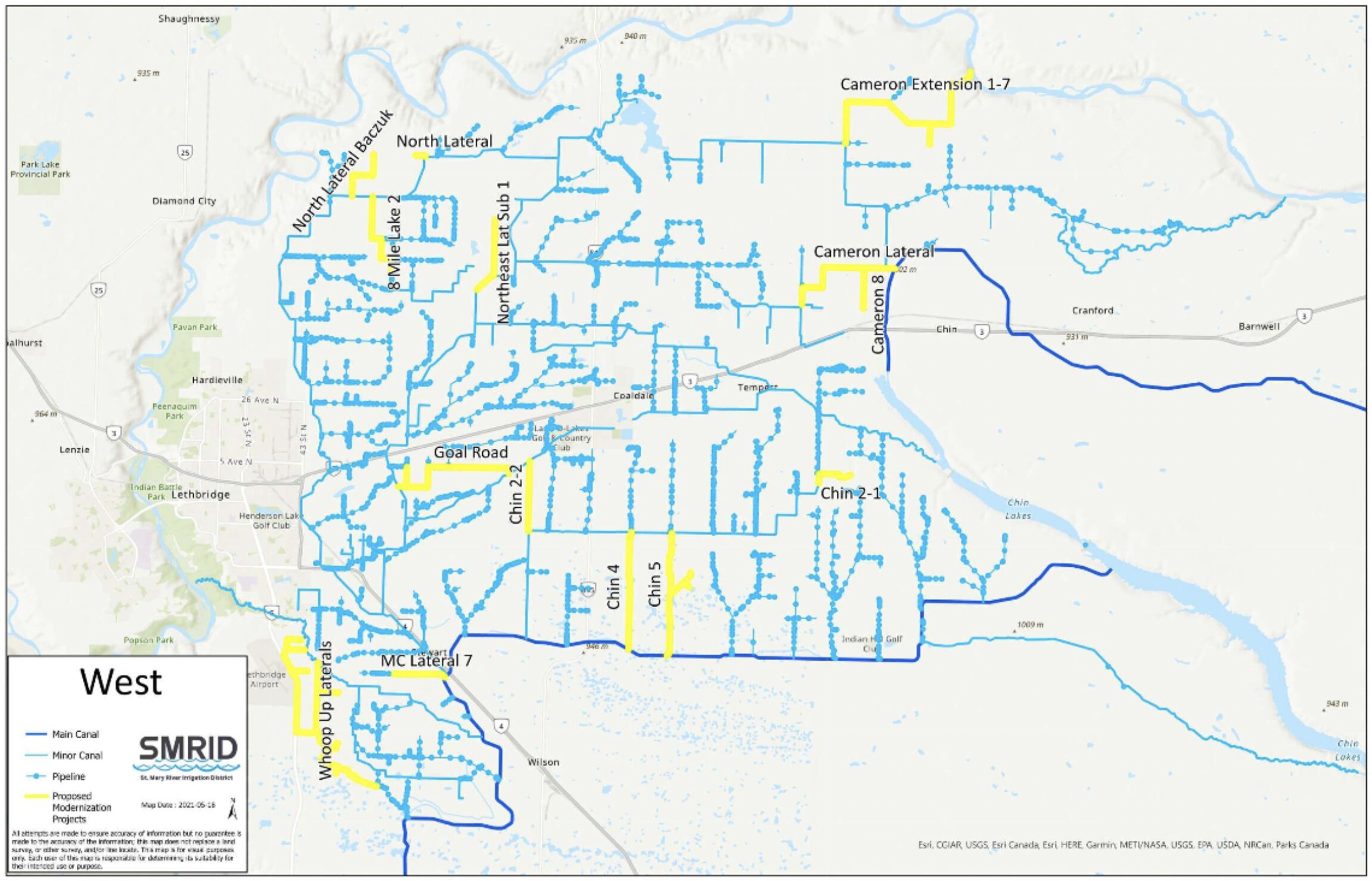
Table 4. 2024/2025 Modernization Projects
| Project Name | Project Description | Cost Estimate |
| Cameron Extension (concrete) | Pipeline | $9,750,000 |
| North Lateral – Sec 13-10-21 | Pipeline | $650,000 |
| Horsefly 6 | Pipeline | $975,000 |
| Yellow Lake 8, 9, 10, IOA (phase 2) | Pipeline | $12,285,000 |
| SMRID Grassy Lake Project | Pipeline/canal rehabilitation | $3,100,000 |
| West Medicine Hat 10/12 (phase 2) | Pipeline | $7,312,500 |
Total Cost of all modernization projects = $164 M
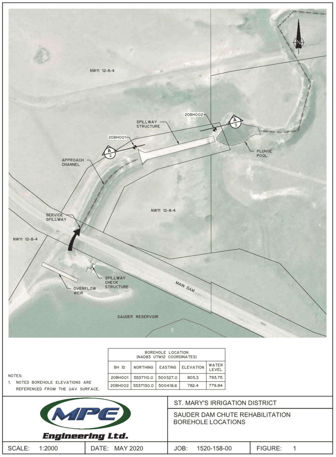
Sauder Chute Spillway and modernization project
The Sauder project will replace an existing cast-in-place chute spillway system that was constructed in 1954 and is in deteriorated condition. The spillway will be enlarged to better accommodate large flood events, and a new automated spillway gate and control system will be added. The enlarged gate system and controls will enhance the level of water management and reduce spill by having a higher level of control at higher water levels.
Sauder Reservoir is located approximately 21 kilometres southwest of the City of Medicine Hat, and is an important off-stream storage reservoir for the eastern part of the SMRID. The primary service spillway for the reservoir is the Sauder Chute, located on the left abutment of the Sauder Main Dam. The chute was constructed with the Main Dam in 1954 and the inlet channel was constructed in 1981. A small bridge currently carries Township Road 121A over the inlet channel.
The existing Sauder Chute structure is a cast-in-place concrete chute with a flip bucket and plunge pool. Water enters the chute during flood events through the inlet channel and is discharged into a natural coulee downstream of the chute. The coulee then carries the water into the South Saskatchewan River.
Flow into the chute is controlled at the head of the inlet channel by the inlet structure equipped with an overshot gate to control flow down Sauder Chute. A grouted rip rap overflow weir is located adjacent to the inlet structure with a crest height at the reservoir FSL of 804 metres, allowing for the passage of flood flows.
The original design capacity of the chute was 32.3 m3/s at the reservoir design flood elevation of 804.65 metres. The proposed replacement spillway is a cast-in-place chute structure with a conventional USBR Type Ill stilling basin. Based on the 2014 Storm Water Management Plan and 2020 Dam Safety Review, the replacement structure was designed for a higher capacity of 75 m3/s to allow passage of flood flows from the SMRID Main Canal upstream. The higher capacity will require a wider replacement structure, as well as an expansion of the inlet channel. The current grouted rip rap overflow weir will also need to be replaced with an erodible fuse plug.
Schedule
This project is scheduled for completion in the 2021/2022 construction season.
Cost Estimate
The total cost of all components of the replacement project is estimated at $13 M.
Reservoir Projects
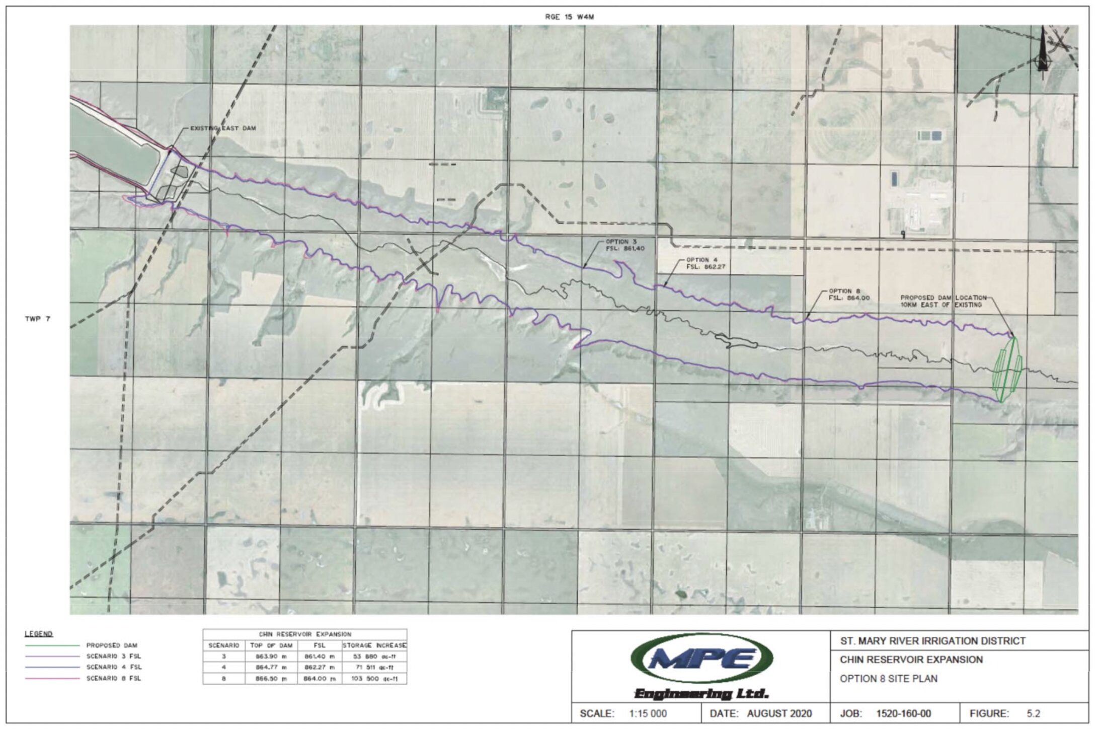
Chin Reservoir Expansion and Modernization project
This project will expand Chin Reservoir, which is an existing off‐stream reservoir on the St. Mary main canal located in TWP 8, RGE 17 and RGE 18 and TWP 7, RGE 16 and RGE 17 – W4M. It is planned to relocate the east dam to Section 23 TWP 7‐RG 15 – W4M, to be located approximately 30 kilometres southeast of the town of Taber. In addition to increasing water storage, an important aspect of the project is modernizing the existing ancillary reservoir structures for aligning with provincial dam safety regulations and increasing the flood handling capacity of the reservoir. This includes construction of a new east dam, replacement of the existing cast-in-place outlet at the west dam and replacement of the Chin chute inlet spillway. The west dam will also have to be raised and the road over the crest of the dam re‐done.
The reservoir capacity will be increased by raising the height of the existing dams and re‐locating the east dam by 10 kilometres, which will add 75000 to 100000 acre-feet of storage, with a flooded area of approximately 650 hectares required for the new section.
Increased storage at Chin reservoir will benefit the Taber, Raymond and St. Mary River Irrigation Districts with increased water security. The three districts currently have a joint agreement for management and maintenance costs on the main canal as well, as shared ownership of three small Hydro power facilities on the St. Mary main canal.
Environmental and engineering investigations are underway, meetings with affected landowners are ongoing, and discussions with government officials on the regulatory approval process are occurring. The current land use within the reservoir footprint is agriculture, with all land privately owned.
Schedule
Construction will begin once the design is completed, the land is acquired, all regulatory requirements are met and approvals are received, which will hopefully be no later than early 2023. Completion of the project will take up to two years once construction commences.
Cost Estimate
Preliminary estimate: $133 M.