Athabasca River Historical Report
Historical Review: Athabasca River
To read the full report please download the document listed in the sidebar.
Executive Summary
In early June, 2013, north eastern Alberta experienced a significant flood event that washed out roads, disrupted business in the oil sands region, and caused millions of dollars of damage in the Regional Municipality of Wood Buffalo, and specifically in the city of Fort McMurray. The purpose of this study is to review historical records of the Athabasca River as they relate to water management strategies, plans and studies to see if there are ideas that could be developed for flood mitigation.
Our review of historical maps, reports and investigations of the Athabasca River identified a number of potential storage options that might help improve watershed management, specifically for flood mitigation. The study confirmed that the Athabasca River was developed primarily as a transportation route. The historical water storage options discovered were in the form of hydroelectric power development, storage basins, water storage sites and diversion projects on the Athabasca River. These options were planned but never developed. The historically proposed water resource management strategies should be reviewed and considered when planning the future development of the Athabasca River basin.
Introduction
Alberta was devastated by the Great Flood of June 2013. Countless families, homes, businesses, properties, infrastructures and shared lands were affected. Following the immediate and necessary response and recovery efforts undertaken, the Government of Alberta (GoA) is carefully identifying, considering and assessing the appropriate actions to mitigate, manage and help control future flooding events. Numerous ideas, proposals, and mitigation strategies are currently being assessed for feasibility and will be subject to final approval by the GoA.
The first major flood event in June, 2013 occurred in the lower Athabasca River basin, on the Hangingstone and Clearwater Rivers upstream of Fort McMurray. This significant flood event washed out roads, disrupted business in the oil sands region, and caused millions of dollars of damage in the Regional Municipality of Wood Buffalo, and specifically in the city of Fort McMurray. The purpose of this study is to review historical records of the Athabasca River as they relate to water management strategies, plans and studies to see if there are ideas that could be developed for flood mitigation.
Within the Athabasca River watershed, there are historical maps, reports and investigations that contain information with respect to the development of this watershed over the past 120 years.
From early Canadian history, we know that the Athabasca River was developed primarily as a transportation route, starting with David Thompson who mapped the first navigable trade route through the Canadian Rockies in the very early 1800’s. As the river opened up the Canadian north and west to trade, the vast resource potential of the river basin was recognized. As the resources were developed, communities sprang up along the Athabasca River and her numerous subsidiaries. Inevitably, there were challenges in managing the interactions between the increasing industry, growing population and the swiftly flowing rivers. A review of the historical records shows that at different times, various options were researched for managing the flows in the Athabasca and her tributaries. The historical water storage options assessed were in the form of hydroelectric power development, storage basins, water storage sites and diversion projects. These options will be presented and reviewed in this study.
It should be noted that the Athabasca River commands a special respect among aboriginal Canadians as well as historians and outdoor enthusiasts. In 1989, the Athabasca River was designated a Canadian Heritage River for its importance to the fur trade and the construction of railways and roads opening up the Canadian West, as well as for its natural heritage.
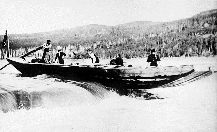 |
| Figure 1: Hudson’s Bay Company’s scow in Athabasca River, circa 1910 |
Historical Review
The Athabasca River and its various tributaries, particularly the Clearwater and Lesser Slave rivers, have played a critical and unique role in the development of Alberta by serving as a transportation route used for the fur trade and the investigation and development of the mining and petroleum resources of northern Alberta.
Hydrometric data was collected on the Athabasca River beginning in 1912 primarily to determine the potential for hydroelectric power development, and five sites were identified. In the early 1900s the Athabasca River was also reviewed for potential storage basins. Four storage basins were identified.
In the 1950s the Athabasca was considered for diversion to the North and South Saskatchewan Rivers to augment water supply within these basins.
From the 1970s onward further storage was considered on the Athabasca for flood mitigation and for the purpose of securing a yearly water supply for the growing oil sands development within the region.
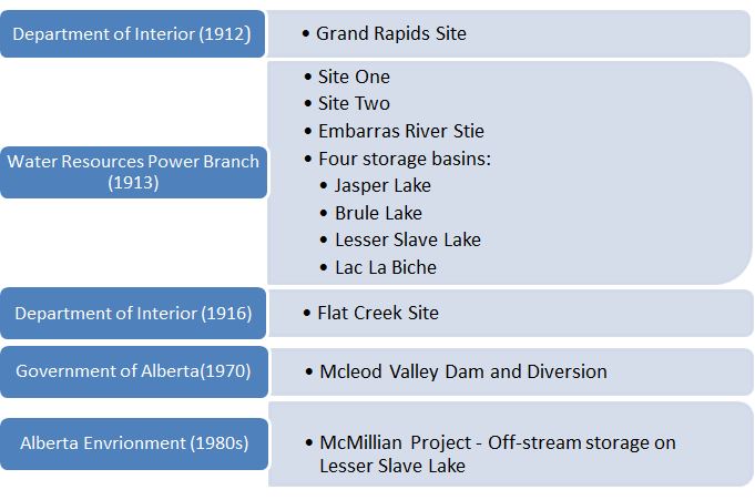 |
| Figure 2: Timeline of historical proposed detention and diversion sites on the Athabasca River |
Fur Trade on the Lower Athabasca
The fur trade began with the arrival of Peter Pond in 1778 (Gough, 1983). He discovered the Athabasca River after crossing the Methye Portage which linked the Clearwater, Athabasca and Mackenzie River basins to the North and South Saskatchewan River basins. Various companies including the Hudson’s Bay and the North West Company developed the Athabasca-Mackenzie transportation corridor (Parker 1987, Rich, 1967). In 1786, Fort Resolution, on the south shore of Great Slave Lake, was first established as a North West Company post. In 1788, Fort Chipewyan located at the junction of the Athabasca, Peace and Slave Rivers, was established as the North West Company, and became the dominant centre for the operation of the fur trade (Parker 1987, Rich, 1967). Fort McMurray was established in 1870 by Henry John Moberly of the Hudson’s Bay Company for the purpose of improving and regulating the use of the Methye portage (Comfort, 1975).
Fur Trade on the Upper Athabasca
The role of the upper Athabasca in the fur trade began with the establishment of the first Jasper House by the North West Company in 1813 (McCarthy, 1976). It served the needs of its employees and others who were crossing the mountains via the Athabasca Pass. Following the amalgamation of the Hudson’s Bay and the North West Companies in 1821, the Hudson’s Bay Company established Fort Assiniboine, in 1823, to serve as part of a new transcontinental transportation system. This route included the Athabasca River from Fort Assiniboine to Jasper House. From there, travellers continued to access Athabasca Pass via the Whirlpool River. This route was in use through to 1861 by which time maritime routes to the Pacific coast had been established.
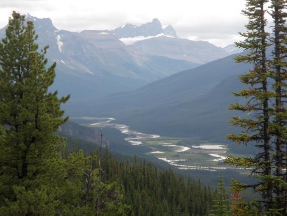 |
| Figure 3: Whirlpool River and Athabasca Pass |
Transportation Revolution
The role of the lower Athabasca River as a transportation route into northern Canada was revolutionized in 1883 with the introduction of stream boats and the construction of the Canadian Pacific Railway across southern Alberta in the same year (Zaslow, 1971). Between 1883 and 1887 the Hudson’s Bay Company put three steamboats in service; the Athabasca, the Grahame and the Wrigley. The Athabasca steam boat operated above and below Athabasca Landing. The Grahame operated on the lower Athabasca, Slave and Peace Rivers and Lake Athabasca. The Wrigley operated from Fort Smith on the Slave River north to the Arctic Ocean. Steamboat operations by the Hudson’s Bay Company and other companies were extended below Athabasca to the modern day community of Smith and on Lesser Slave River and Lesser Slave Lake as far west as Grouard.
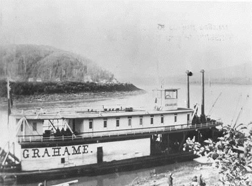 |
| Figure 4: Grahame Steamboat (Glenbow Archives, 1899) |
The southern railway network was initially built to connect to the riverboats transportation routes on the Athabasca, Slave and Mackenzie Rivers by way of Calgary and Edmonton Trail and the Athabasca Landing Trails. The link to the northern river system was improved with the construction of railways to South Edmonton in 1891, Athabasca Landing in 1910, Peace River in 1916 and Waterways on the Clearwater River in 1921. In 1925, waterways were moved when the railway was extended to a location close to Fort McMurray immediately southeast of the Hangingstone River. This extension was made to improve the shipping operations on the Clearwater and Athabasca Rivers.
Economic Diversification
The transportation revolution on the Athabasca was followed in the 1890s by the diversification of the economy with the addition of mining and petroleum exploration and eventually development (Hunt, 2011, Zaslow, 1971). Investigation of mining and petroleum resources began with the arrival of members of the Geological and Natural History Survey of Canada in the 1880s. The first northern mining rush began in the summer of 1897 following the discovery of gold in the Yukon in the middle of August 1896. One possible route to the gold fields was via the Athabasca and Mackenzie Rivers to Fort McPherson and then east via the Rat, Bell and Porcupine Rivers to the Klondike. During the summer of 1897, 1898 and 1899 many parties attempted this route with only a few being successful. The majority either turned back or pursed the economic opportunities along the Athabasca and Mackenzie Rivers. The possibility of gold being discovered at the eastern end of Great Slave Lake and the oil resources of the lower Athabasca River were two of these distractions. Count Alfred von Hammerstein was one of the first would-be Klondikers who remained in the Fort McMurray area to pursue the development of the oil sands.
Historical Hydrometric Surveys on the Athabasca River
The collection of hydrometric data began in 1912 when Department of Interior hydrographer G. H. Whyte took various miscellaneous measurements in the Athabasca Landing (Department of Interior, 1912). The establishment of permanent gauging stations began on February 27, 1913 when Victor Meek established a station on the Athabasca River at Athabasca Landing. Additional stations were established later that year on the Athabasca River near Jasper, on the Rocky River near Hawes, on the Miette River near Jasper and on the Lobstick River near Entwistle (Department of Interior, 1913).
Historical Documentation of Flooding on the Athabasca River
The first flood recorded by these stations happened in 1915 (Department of Interior, 1915). The report for this year noted that no records of previous floods on this stream were available although such floods were known to have occurred with 1899 considered to be the largest in memory of people living at that time. Mr. Swift, the oldest resident of the Yellowhead Pass, was quoted as saying that the flood of 1915 was the largest he had witnessed at Jasper. The damage caused by the flood was considered minimal since there was little settlement close to the banks of the streams. Subsequent floods did, however, impact waterways and are documented by photographs taken in 1935 and 1936. These photos are available for viewing at the Alberta Provincial Archives located in Edmonton Alberta.
The majority of the flooding data that exists for the Athabasca watershed is from historical written accounts that are mainly descriptive from sources like the Hudson Bay Company journals, post in the Fort Chipewyan and Fort Vermillion and the records of the Roman Catholic Mission in Fort Chipewyan and Wood Buffalo National Park. More recent history is provided by local knowledge and is generally restricted to major flooding events. The historical written accounts of flooding on the Athabasca dates back to 1803 and is primarily caused from ice jamming. Historical written accounts note that between the years 1915 to 1950 was a time of unusually frequent floods with ten major floods occurring between 1932 and 1948. Historical accounts of flooding on the Athabasca found that a flood was more likely to occur if a flood had occurred in the previous year (Peace-Athabasca Technical Studies Group. 1996).
Historical Hydroelectric Development on the Athabasca
The uses of the Athabasca River beyond its role as meeting the transportation needs of the northern fur and mining frontier were first considered in 1912. In August of that year C. H. Attwood of the Department of the Interior, Water Power Branch was sent to the Grand Rapids to investigate possible water storage on the Athabasca. The issue with further development of the Grand Rapids Site (see Map 1) was not based on engineering feasibility but the lack of a local economic market for the power produced. The demand at Athabasca Landing was small and Edmonton which offered the best market was too far away. The potential storage capacity of the Grand Rapids was never recorded (Hendry, 1913).
In 1913, the Water Resources Power Branch shifted its investigations for possible sites for hydroelectric development further west. Two sites immediately west of the confluence of the Athabasca and Berland Rivers were selected for study (see Map 1). The Town of Hinton located 80 kilometres (km) south of this confluence was the nearest community. The dam proposed for Site One, (see Map 1) was to be 24 metres (m) high and 167m wide. The drainage area of the Athabasca River above the power site was described as virgin forest with the greater part of the headwaters being located in Jasper Park Forest Reserve. During the 1913 investigation four potential storage basins were identified Jasper Lake, Brule Lake, Lesser Slave Lake and Lac La Biche (see Map 1). The potential storage capacity for the four basins identified in 1913 were never recorded (Hendry, 1913). Lesser Slave Lake was later reviewed, under the McMillian Project, for its potential as off-stream storage for oil sands development in the 1980s, see section 3.9.
Site Two (see Map 1) located 19 Km upstream from Site One had less potential for power development. The investigation concluded that while the two sites were feasible from an engineering standpoint, they did not appear attractive from an economic point of view since they were also too far from a growing economic market located in Edmonton (Hendry, 1913).
A third site the Embarrass River Site (see Map 1) was also considered for its potential to developed hydroelectricity but due to the low flow volumes of water at this specific location hindered further development of the Embarrass River Site.
The potential storage capacity of the three sites identified by the Water Resources Power Branch were not recorded (Hendry, 1914).
In 1916, the Department of Interior Topographical Surveys presented a detention site for hydroelectric power. The Flat Creek Site (see Map 1) was situated on Flat Creek, a tributary of Flat Lake. No storage capacity estimates were ever recorded for this proposed power generation location (Department of Interior, 1916).
In this review of historical records a total of five sites were identified for their potential in hydroelectric power development. The five sites identified were: Grand Rapids, Site One, Site Two, Embarrass River Site and Flat Creek Site (see Map 1). These sites were only conceptualized and never built. The main driver halting their further development was their location. The sites identified were found to be too far from growing economic markets in Edmonton. The lack of community settlements throughout the Athabasca River deterred investment in the development of the five proposed hydroelectric dams.
McLeod Valley Dam and Diversion on the Athabasca River
Throughout the 1950s and 1960s the GoA undertook a number of studies that discussed diverting water from the Athabasca River to the North and South Saskatchewan Rivers. In 1970 the Water Resources Division of the Alberta Department of Agriculture, prepared a Preliminary Engineering Report on the Investigation and Design of the McLeod Valley Dam. The McLeod Valley Dam was to be located 32 kilometres (km) northeast of Edson, Alberta, near the hamlet of Peers, Alberta. The diverted water would flow through a constructed channel to Chip Lake. The dam and diversion system was designed to mitigate flows for a probability measure of 0.2% chance of flooding. The McLeod Valley Dam was estimated to store approximately 694,084 cubic decametres (dam3) of water. The dam was planned but never constructed. The project was eventually abandoned due to rising construction costs and growing environmental concerns (Alberta Department of Agriculture, 1970).
Off-Stream Storage on the Athabasca
From the 1980s onward, off stream storage on the Athabasca was presented as a possible avenue to secure water resources for the growing oil sands industry. Off-stream storage is less controversial than on-stream storage as it does not hinder the natural flow of the river. Off-stream storage supports the natural flow of fish passage and sediment movement within the river channel. With off-stream storage river water flows are diverted or pumped to natural water bodies such as lakes. These lakes are then fitted with structures in order to enhance the water supply capacity of their catchment.
The Lesser Slave Lake Storage Basin
In the 1983s, Lesser Slave Lake was fitted with outlet control works for flood management, fish passage and enhanced recreation. Local stakeholders and the GoA are currently exploring additional structures on Lesser Slave Lake that would allow this water body to hold more storage to supply the growing water demand downstream.
Lesser Slave Lake was previous identified in history as a potential storage Basin by the Water Resource Branch of the Department of the Interior in 1913.
Off- Stream Storage Basins for Oil Sands Development
In 2001, Alberta Environment commissioned Golder & Associates to present solutions for the issue of growing water demanded by oil sands companies. On the Athabasca River, low flow periods during the winter months created a limited water supply to meet the increasing water demand. Golder concluded with the recommendation that off-stream storage within the Athabasca River was one potential way to secure a yearly water supply for the development of oil sands within the region (Golder, 2010 & University of Alberta, 2007).
One off-stream storage solution presented by Golder was known as the McMillian Project. The McMillian Project would capture peak flow water from the Athabasca River to be stored in an outlet at McMillian Lake. The McMillian project would then gradually release the water back into the river system in order to supplement flows of the Athabasca River from downstream withdrawals. It was proposed that McMillian Lake be raised three to five metres so that it could facilitate the storage of 1000 dam3 (Golder, 2010. & Irvine. B et al. 2008).
A number of other potential off-stream storage sites were also suggest including Lesser Salve Lake, McClelland Lake, Kearl Lake, Lake Athabasca and Lake Claire(Alberta Environment, 2008 & Golder, 2010).
Summary of Findings
Table 1: Historically Identified Storage Sites on the Athabasca River
| Historical Concept | Year Conceptualized |
Storage Capacity (dam3) |
Comments |
| Grand Rapids Site | 1912 | – | Hydroelectric Power Development |
| Site One | 1913 | – | Hydroelectric Power Development |
| Site Two | 1913 | – | Hydroelectric Power Development |
| Embarras River Site | 1913 | – | Hydroelectric Power Development |
| Jasper Lake | 1913 | – | Storage Basin |
| Brule Lake | 1913 | – | Storage Basin |
| Lesser Slave Lake | 1913 | – | Storage Basin |
| Lac La Biche | 1913 | – | Storage Basin |
| Flat Creek Site | 1916 | – | Hydroelectric Power Development |
| McLeod Valley Dam | 1970 | 694,084 | Flood Mitigation |
| Lesser Slave Lake | 1983 | – | Storage Basin for Flood Mitigation |
| McMillian Lake Project | 2001 | 1000 | Storage Basin for Oil Sands Development |
|
Off-stream storage Basins : Lesser Slave Lake, McClelland Lake, Kearl Lake, Lake Athabasca and Lake Claire |
2001 | – | Storage Basins for Oil Sands Development |
The purpose of this study is to review historical records of the Athabasca River as they relate to water management strategies, plans and studies to see if there are ideas that could be developed for flood mitigation.
Within the Athabasca River watershed, there are historical maps, reports and investigations that contain information with respect to the development of this watershed over the past 120 years.
A review of the historical records shows that at different times, various options were researched for managing the flows in the Athabasca and her tributaries. The historical water storage options presented were in the form of hydroelectric power development, storage basins, water storage sites and diversion projects.
Current development of the Athabasca is centered on possible off-stream storage basins that would augment winter flows creating a secure water supply for growing oil sands development within the region. Due to the increased economic development the potential for damming the Athabasca for hydroelectric power is currently being review. One potential site that is still under consideration is just upstream of the historically identified 1912 Grand Rapids Site. As mentioned previously the sites identified by the Department of Interior in the early 1900s for hydroelectric power development were found to be entirely feasible but were halted due to the lack of nearby economic markets demanding power. With the growing regional development on the Athabasca River there are now emerging economic markets that require power supply.
Conclusion
In conclusion, it is important to better understand where we have come from, how we have historically viewed and developed our watersheds, and how these past proposals could apply to our present situation. In reviewing historical maps, reports and investigations of the Athabasca River identified a number of potential storage options. The options identified were in the form of hydroelectric power development, storage basins, water storage sites and diversion projects on the Athabasca River. These historically proposed strategies should be taken into account when considering future development of the Athabasca River.
References
[1] Alberta Department of Agriculture. 1970. Preliminary Engineering Report on the Investigation and Design of the McLeod Valley Dam
[2] Alberta Environment. 2008. Water for Life: Alternative Water Supply Storage and Management Methods water for life Adding Tools to Alberta’s Water Toolbox
[3] Comfort, Darlene. Alberta History. Autumn 1975. William Murray: the name behind the fort
[4] Department of Interior Topographical Surveys. 1916. Vol. LI no. 19. Sessional Papers
[5] Department of Interior. 1915. Report of Stream Measurements for the Calendar
[6] Department of Interior. 1913. Report of Stream Measurements for the Calendar
[7] Department of Interior. 1912. Report of Stream Measurements for the Calendar
[8] Fumoleau, Rene. 1975. As long as this land shall last: a history of Treaty 8 and Treaty 11, 1870-1939
[9] Golder Associates. 2010. Engineering Mitigation Options for Meeting the Athabasca River Water Management Framework
[10] Gough, Barry. 1983. Peter Pond, Dictionary of Canadian Biography
[11] Hendry, M.C., 1914. Annual Report of the Department of the Interior for the Fiscal Year Ending March 31, 1914
[12] Hendry, M.C. 1913. Annual Report of the Department of the Interior for the Fiscal Year Ending March 31, 1913
[13] Hunt, Joyce. 2011. Local Push Global Pull: The Untold History of the Athabasca Oil Sands 1900 – 1930
[14] Irvine., B. & Berzins, B. Sept/Oct 2008. Canadian Institute of Mining, Metallurgy and Petroleum. One, two, three … green light Innovative approaches to water quality management on Athabasca River. Retrieved March 31, 2014 from: https://magazine.cim.org/en/September-October-2008/features/One-two-three.aspx?page=2 [dead link]
[15] Parker, James. 1987. Emporium of the North: Fort Chipewyan and the fur trade to 1835
[16] Peace-Athabasca Technical Studies Group. 1996. Peace-Athabasca Delta technical studies final report
[17] Rich, E.E. 1967. The fur trade and the Northwest to 1857
[18] University of Alberta. 2007. Running out of Steam? Oil Sands Development and Water Use in the Athabasca River-Watershed: Science and Market based Solutions
[19] Zaslow, Morris. 1971. The opening of the Canadian north, 1870-1914