Elbow River Historical Detention and Diversion Sites
Historical Review: Elbow River
To read the full report please download the document listed in the sidebar.
Executive Summary
The purpose of this study is to review historical records to identify previously proposed detention and diversion sites on the Elbow River, and determine if these historical sites have any merit for further investigation and consideration by the Government of Alberta (GoA) as an alternative to the mitigation options currently being reviewed by the Flood Recovery Task Force.
An initial historical review of potential detention and diversion sites on the Elbow River provided twelve possible options that could be implemented to mitigate for both flood and drought.
Of the twelve identified historical detention and diversion sites it is recommended that the Priddis Creek diversion be seriously considered as an option for flood and drought mitigation. The Priddis Creek diversion is designed to mitigate for flooding upstream of Bragg Creek and the City of Calgary using the natural creek bed and low lying topographical areas for channeling the water flows. By using natural topography the Priddis Creek diversion has a greater potential to slow down the water; subsequently reducing peak flows. It is also recommended that the historical resevoir sites identifed by the Department of Interior in the 1890s, along with the McLean Site, should be further investigated for feasibility. These storage sites are recommended due to their use of natural topography and their ability to mitigate for flooding upstream of Bragg Creek and the City of Calgary.
In order to ensure that all the flood mitigation options are considered for all watersheds throughout Alberta, Alberta WaterSMART recommends further investigation into all mitigation options by continuing to undertake this type of historical analysis for all watersheds throughout Alberta.
Introduction
Alberta was devastated by the Great Flood of June 2013. Countless families, homes, businesses, properties, infrastructures and shared lands were affected. Following the immediate and necessary response and recovery efforts undertaken, the GoA is carefully identifying, considering and assessing the appropriate actions to mitigate, manage and help control future flooding events. Numerous ideas, proposals, and mitigation strategies are currently being assessed for feasibility and will be subject to final approval by the GoA.
Within the Elbow River watershed, there are historical maps, reports and investigations that contain information with respect to detention and diversion sites that were proposed for use in flood and drought mitigation strategies. Some of these sites were studied to the point where engineering schematics were completed. For a variety of reasons, these proposed mitigation strategies were never carried through to implementation.
The purpose of this study is to review historical records to identify previously proposed detention and diversion sites, and determine if these historical sites have any merit for further investigation and consideration by the GoA as an alternative and or complement to other mitigation options currently being reviewed. Note that detailed historical records exist for all of Alberta, but for the purposes of this study, the historical review will be limited to the Elbow River watershed upstream of the City of Calgary and Bragg Creek.
Upon reviewing the past 100 to 110 years of historical documentation WaterSMART Solutions Ltd. (WaterSMART) uncovered a number of possible options that could be implemented as a part of a comprehensive plan for both flood and drought mitigation.
In 2008, the GoA conducted a study on potential diversion and detention sites throughout all watersheds within Alberta. This study was entitled the 2008 Water for Life Assessment of Potential Water Storage and Diversion Scenarios (GoA, 2008). In this report all historical diversion and detention sites identified on the Elbow River during this review were compared to the 2008 Report to determine if they have previously been considered for feasibility.
Historical Review
The chronological timeline of proposed historical detention and diversion sites located on the Elbow River is described below. It should be noted that while some concepts were originally identified for drought mitigation, and others were identified for flood mitigation, the various proposals offer the potential to address both drought and flood mitigation when considered as part of a comprehensive plan.
The Department of the Interior reservoir sites and the Calgary Irrigation Company canal/Pirmez diversion were originally developed for drought mitigation during the late 1890s. Over the past 50 years, these ideas have continued to be mentioned in flood mitigation reports developed on the Elbow.
The Priddis Creek diversion, along with the Ford, Mitchell, Sarcee and McLean detention sites were all projects put forward over the last 100 to 110 years for flood mitigation on the Elbow River.
Calgary Irrigation Company
The Calgary Irrigation Company was established by William Pearce who was a strong advocate of irrigation as a solution to the periodic droughts that affected the prairie west. The Company intended to provide water to the Town of Calgary and irrigation water to its immediate surroundings (Gilpin, 2010) (see Figure 1).
Pirmez Diversion
This diversion was first conceptualized by the Calgary Irrigation Company in the 1890s (Figure 1). It was subsequently constructed before the turn of the century and is still operable today. The beginning of the Pirmez diversion is located on the Elbow River approximately two kilometres (kms) upstream of the Highway 22 and Highway 8 intersection (Map 1, attached). The diversion flows east approximately 21 kms, intersects and joins Six Mile Coulee, and then divides into two separate legs; one leg flows northeast for approximately 27 km where it terminates in the Bow River, and the other legs flows approximately 42 km southeast terminating in the Highwood River. The total route, including both legs, is approximately 90 kms (Map 1 attached). It is important to note that a substantial portion of the Pirmez Diversion resides within the Tsuu T’ina Reservation.
In a 1986 Elbow River Flood Management Study (WER et al. 1986) published by WER, IBI and ECOs Engineering for Alberta Environment and the City of Calgary, this canal, referred to as the Pirmez diversion, was proposed as a part of a series of flood mitigation concepts. The 1986 Report articulated the key impacts of the Pirmez diversion including:
- the river would be totally altered by substantial channelization and increased flood flows;
- the use of Tsuu T’ina Reservation lands are required and would be affected by channel alignment; and
- recreational facilities in Fish Creek would be impacted by flooding and channelization.
No numbers were reported on the potential storage or diversion flows for the Pirmez concept (WER et al. 1986).
This diversion site was not assessed in the 2008 Water for Life Assessment of Potential Water Storage and Diversion Scenarios (GoA, 2008).
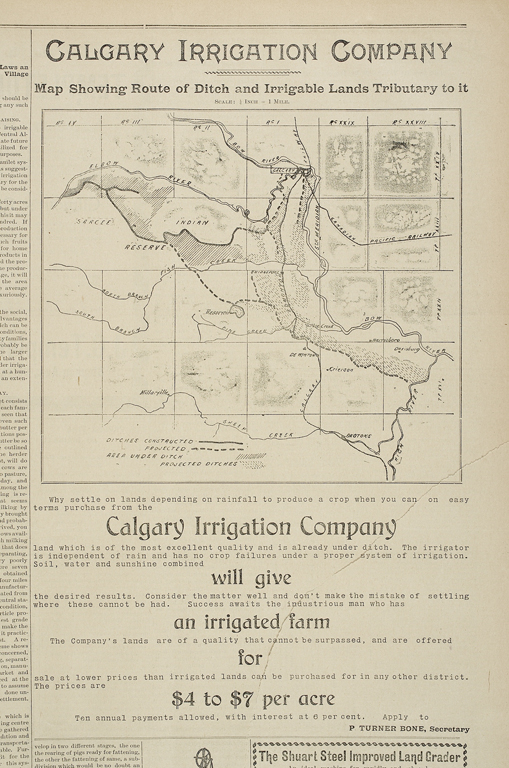 |
| Figure 1: The Pirmez Canal |
Figure 1 above is a clipping from the Calgary Herald dated February 20, 1896 showing the completed length of the canal along with the proposed extension.
Department of Interior
The Department of the Interior was established in 1873 by Sir John A. MacDonald to administer the settlement of the western territory recently acquired from the Hudson’s Bay Company. As part of this responsibility, the Department conducted topographic and hydrographic surveys beginning in the 1890s in the foothills of Alberta to identify the locations of detention sites, canals, diversion points and the potential water supply available for use in the future development of irrigation systems. The annual reports of the Department of the Interior for the 1890s contain detailed outlines of the results obtained.
The detention sites identified in the 1897 Department of Interior Annual Report are presented in section 1.2.1 and 1.2.2 and shown on Map 1.
Department of Interior Storage Sites on the Elbow River
All storage sites identified by the Department of Interior were never constructed only planned.
Reservoir Site D: situated on Canyon Creek, a tributary of the Elbow River, within Sections 28 and 29, Township 22, Range 6, west of the 5th Meridian (28/29-022-06W5M) (Map 1). The proposed location for a dam is presented at the mouth of the canyon within the southwest quarter of Section 28 (SW-28). This site was also identified by the Allan Markin Flood Advisory Panel for a dry detention site referred to as EC1.
Rough capacity estimates are:
With a 21 metre dam 2,097,440 m3
With a 30 metre dam 4,935,152 m3
With a 145 metre dam 9,870,305 m3
Reservoir Site E (including Mitchell Dam Site): situated on the Elbow River within 04/05-022-06W5M and 29/32/33-021-06W5M (Map 1). The proposed location for a dam is presented within the NW-04.
Reservoir Site E was subsequently proposed as a detention site in the 1979 Elbow River Flood Study (Monenco, 1979) by Monenco Consultants prepared for Alberta Environment. This report identified Reservoir Site E and the Mitchell Dam Site for additional upstream storage.
The Mitchell Dam Site, which has also been identified by the Markin Panel as dry detention site EQ1, was reviewed in the 2008 Water for Life Assessment of Potential Water Storage and Diversion Scenarios and was determined to be a geologically unsuitable location for a permanent dam based on a review undertaken by the Prairie Farm Rehabilitation Association (PFRA) in 1969 in which the site was identified to be on highly permeable rockslide debris (GoA, 2008).
Reservoir Site F: situated on Elbow River within 17/20/21-021-07W5M (Map 1). The proposed location for a dam is found within SW-21, where the stream flows between limestone rock walls.
Rough capacity estimates are:
With an 18 metre dam 1,628,600 m3
With a 30 metre dam 4,379,948 m3
Department of Interior Storage Sites on Fish Creek
Reservoir Site G: situated on Fish Creek within 11/12/13/14-022-04W5M (Map 1 and Figure 2). The proposed location for a dam is the NE-12.
Rough capacity estimate is:
With a 10 metre dam 7,526,107 m3
Reservoir Site H: situated on Fish Creek within 10/11/14-022-05W5M (Map 1 and Figure 2). The proposed location for a dam is within SE-14.
Rough Capacity estimate is:
With a 24 metre dam 9,475,493 m3
Figure 2 below is a photograph taken in the 1890s depicting the topography of the area that was chosen for Reservoir Site H.
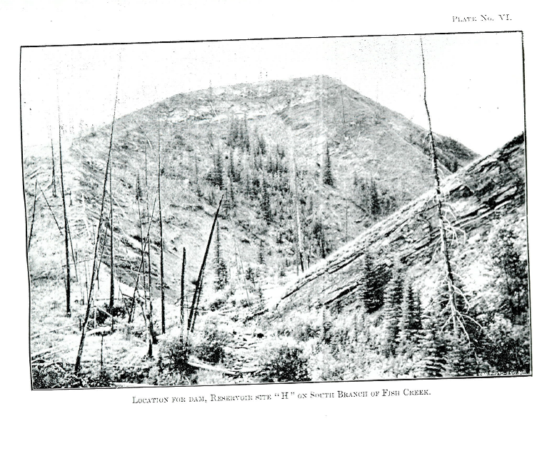 |
| Figure 2: Reservoir Site H South Branch of Fish Creek (Department of Interior, 1897 pVI). |
With the exception of Reservoir Site E, the detention sites identified above were not reviewed in the 2008 Water for Life Assessment of Potential Water Storage and Diversion Scenarios.
Priddis Creek Diversion
The Priddis Creek diversion was first conceptualized in 1900 by the Department of Interior with two on-stream detention sites identified as part of the diversion structure (Department of Interior, 1900) (see Figure 3). Figure 3 presents a map created in 1900 by the Department of Interior, which depicts the historical Priddis Diversion concept of diverting water upstream of Bragg Creek from the Elbow River through the Priddis Creek valley, flowing down into Fish Creek, and ultimately into the Bow River.
No written account of volume estimations for the two proposed detention sites identified on the 1900 Map was discovered during this historical review.
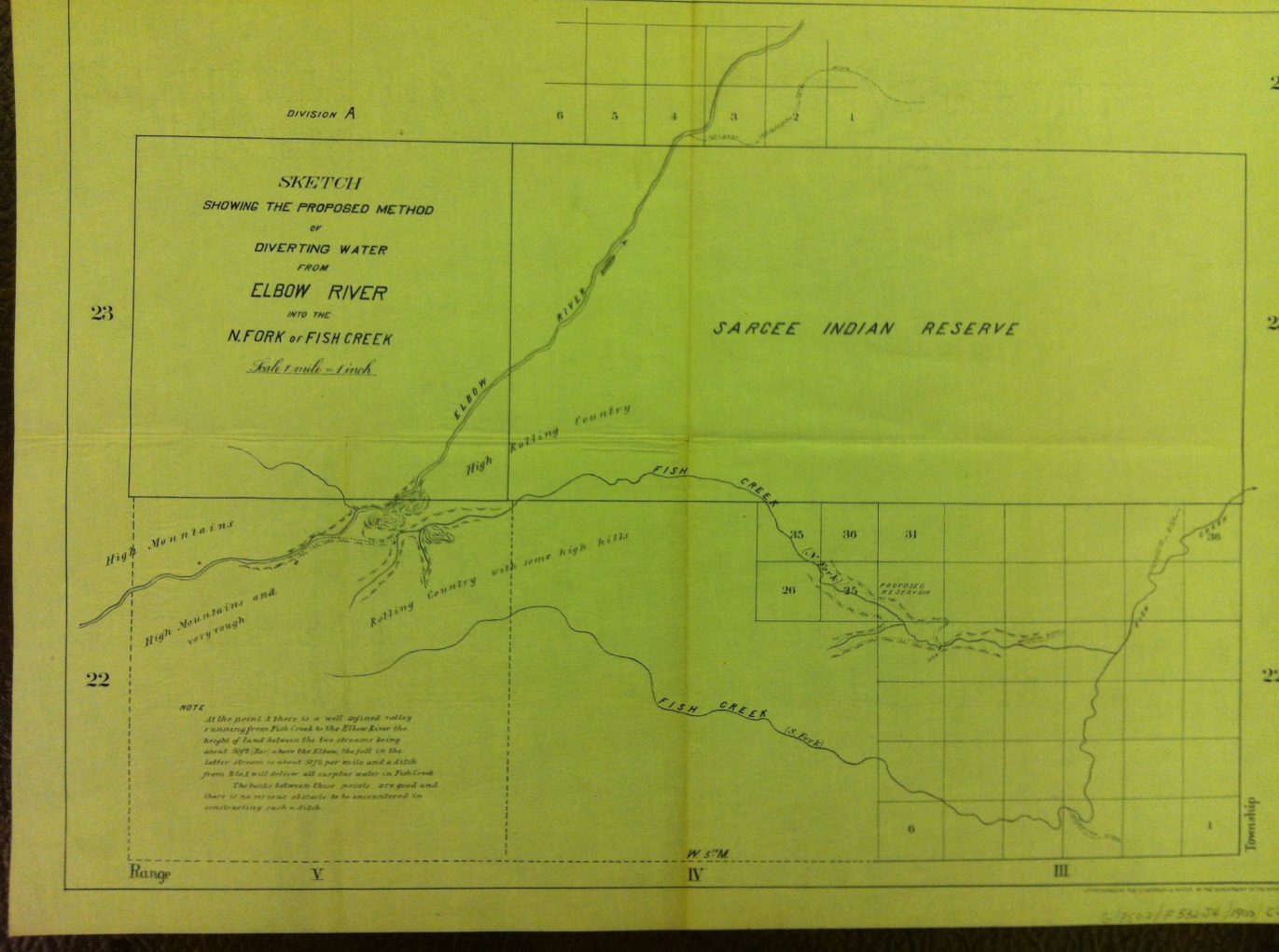 |
| Figure 3: Proposed Method of Diverting Water from the Elbow River to North Fish Creek (Department of Interior, 1900). |
The Priddis Creek diversion was revisited in the 1986 Elbow River Flood Management Study published for the Alberta Environment and the City of Calgary. In this report it was referred to as the Priddis diversion. The diversion was to be located approximately one km upstream of Bragg Creek, in the form of an un-gated constructed weir and a gated diversion network (see Map 1). The diversion would be designed for the gate to be opened during significant flood events, allowing Elbow River water to flow down the channel to the receiving stream. The diverted water would flow along the Priddis Creek valley for 21km to Fish Creek. It would then flow another 26km through the Tsuu T’ina Reserve and Fish Creek Park and ultimately into the Bow River.
The 1986 Elbow River Floodplain Management Study estimated that the Priddis diversion would divert approximately an additional 345 cubic metres per second (m3/s) of water, assuming that the Glenmore Reservoir pre-releases are 283 m3/s. If Glenmore outflow is limited to 170 m3/s then the diversion channels and structures would have to be increased to upwards of 530 m3/s. Figure 4 presents a table taken from the 1986 report outlining the cost of the Priddis Creek Diversion, assumed to cost $68,000,000 (WER et al. 1986).
The 1986 Report articulated the possible key impacts of the Priddis Creek Diversion including:
- the river would be totally altered by substantial channelization and increased flood flows;
- the use of Tsuu T’ina Reservation lands are required and would be affected by channel alignment; and
- recreational facilities in Fish Creek would be impacted by flooding and channelization (WER et al. 1986).
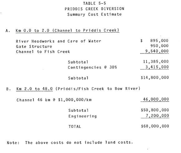 |
| Figure 4: 1986 Cost Estimate of the Priddis Creek Diversion (WER et al. 1986p5-17) |
This diversion site was not assessed in the 2008 Water for Life Assessment of Potential Water Storage and Diversion Scenarios (GoA, 2008).
The 1979 Elbow River Flood Study
In 1979, Alberta Environment Planning Division contracted Monenco Consultants Ltd. to do a flood mitigation study on the Elbow River. Their findings included the development of two on-stream storage sites on the Elbow and the expansion of the capacity of the Glenmore Reservoir.
The two on-stream storage sites are shown on Map 1 and are described below.
Mitchell Site: originally selected in 1914 and located within 4/5/8-022-06W5M (Map 1). The location of this site overlaps with Reservoir Site E as described in Section 1.2.1 of this Report. In 1969 the PFRA determined this site geologically unsuitable and proposed a new site just downstream of the confluence of Ford Creek and Elbow River. This site is referred to as the Ford Site (Monenco, 1979) (Map 1).
Ford Site: originally selected by the PFRA in 1969 located in 24/25-021-07W5M.
Rough capacity estimate is:
40,715,008 m3 (Monenco, 1979)
Both sites were reviewed in the 2008 Water for Life Assessment of Potential Water Storage and Diversion Scenarios. As described above the Mitchell Site was determined to be geologically unsuitable by the PFRA study of 1969 in which the site was identified to be on highly permeable rockslide debris. The Ford Site was problematic due to its location in a naturally protected area (GoA, 2008). It is important to note that the dry detention site proposed by the Markin Panel (referred to as EQ1, Map 1) is located at the proposed Mitchell site and therefore has been predetermined to be geologically unsuitable.
The 1986 Elbow River Floodplain Management Study
In 1986, WER Engineering, IBI Group and ECOs Engineering published the Elbow River Floodplain Management Study for Alberta Environment and the City of Calgary. The study determined the potential of additional upstream storage in the form of the Sarcee and McLean Reservoir sites along with two diversions through Fish Creek Park: the Priddis and the Pirmez diversions (see Map 1).
The additional detention on the Elbow River was proposed as follows:
Sarcee Reservoir/Dam Site: Located approximately 1.5 km upstream of the Glenmore Reservoir immediately west of the “Weaselhead”.
Rough Capacity estimate is:
With a 22 metre dam 1,738,000m3
With a 26 metre dam 2,380,000 m3
Key Impacts of the proposed Sarcee Site include:
- part of the military reserve would be subject to flooding;
- very few residencies or agricultural land would be directly impacted;
- habitat for wildlife affected;
- fish spawning impacted;
- Weaslehead area encroached upon;
- Sacree Trail affected;
- Tsuu T’ina Reservation lands required; and
- siltation rate in Glenmore reduced (WER et al. 1986).
McLean Reservoir/ Dam Site: Located upstream of Bragg Creek.
Rough Capacity estimate is:
With a 25 metre dam 831, 000 m3
With a 46 metre dam 2,024,000 m3
Key impacts of the proposed McLean Site include:
- parts of Kananaskis Country impacted;
- highway 66 relocated;
- wildlife habitat affected; and
- some degree of flood protection afforded to Bragg Creek (WER et al. 1986).
Neither of these detention sites were reviewed in the 2008 Water for Life Assessment of Potential Water Storage and Diversion Scenarios (GoA, 2008).
Potential Detention and Diversion Volume
Based on the Allan Markin Flood Advisory Panel’s review of the 2013 flood event it is estimated that there would have to be a total temporary storage capacity of 100,000,000 m3 upstream of the Glenmore Reservoir in order to fully mitigate the 2013 flows to 180 m3/s downstream of the Glenmore Reservoir. Flows above 180 m3/s, downstream of the Glenmore Reservoir, would require the implementation of protective measures such as sand-bagging to prevent flooding of private property (Carnduff, R., 2013).
The potential detention and diversion volumes for the various historical proposals are shown in Table 1.
Table 1: Historical Detention and Diversion Volume
| Historical Concept | Storage Capacity (m3) | Estimated Flow Diversion (m3/s) | Comments |
| Reservoir Site D |
2,097,440 / 4,935,152 / 9,870,305 |
– | 70 / 100 / 150 foot dams |
| Reservoir Site E/Mitchel Site | 31,461,597 | – | 115 foot dam, geologically unsuitable for a permanent dam |
| Reservoir Site F |
1,628,600 / 4,379,948 |
– | 60 / 100 foot dams |
| Reservoir Site G | 7,526,107 | – | 35 foot dam |
| Reservoir Site H | 9,475,493 | – | 80 foot dam |
| Ford Site | 40,715,008 | – | – |
| McLean Site |
831,000 / 2,024,000 |
– | 74/86 foot dams |
| Sarcee Site |
1,738,000 / 2,380,000 |
– | 85/ 154 foot dams |
| Priddis Reservoir Site 1 | – | – | – |
| Priddis Reservoir Site 2 | – | – | – |
| Priddis Diversion | – | 345 | Assuming Glenmore pre-releases of 283 m3/s; If pre-releases of Glenmore is 170m3/s then the diversion channels and structures would have to be increased to upwards of 530m3/s |
| Pirmez Diversion | – | – | – |
| Total | 95,473,245 | 345 |
Implementing a series of detention and diversions on the Elbow River, as outlined in this historical review and shown in Table 1 above, has the potential to mitigate for future floods and store water for future droughts. Furthermore, there is the potential to detain more water on the Priddis Creek Diversion along with the potential to divert more water via the Pirmez Irrigation Canal.
Table 2 : Allan Markin Flood Advisory Panel Proposed Projects on the Elbow Detention and Diversion Volumes
| Markin Panel Elbow River Concept | Storage Capacity (m3) | Estimated Flow Diversion (m3/s) | Comments |
| EC1 | 12,000,000 | – | |
| EQ1 | 70, 000,000 | – | Geologically unsuitable location for a permanent dam based on the PFRA 1969 Study |
| CB1 | – | 500 | |
| Total | 82,000,000 | 500 |
(Source: Carnduff, R. 2013)
Summary of Findings
In review of the potential detention and diversion sites located on the Elbow River watershed some concepts have a greater potential for flood and drought mitigation based on differing factors including:
- Flood mitigation potential upstream of both Bragg Creek and the City of Calgary;
- Drought mitigation potential;
- Topographical design of the detention site;
- Engineer work already completed on concept;
- Whether or not the project is located on the Tsuu T’ina Reservation due to complications around developing on First Nations Land;
- Whether the project was discouraged in the 2008 Water for Life Assessment of Potential Water Storage and Diversion Scenarios; and
- If the project has potential to slow down water and reduce peak flows.
Table 3 below shows the concepts that have the greatest potential for flood mitigation. These concepts are identified in green on Map 1.
Table 3: Concepts with the Greatest Potential for Flood Mitigation
| Concept | Comments |
| Priddis Diversion |
|
| Priddis Reservoir Site 2 |
|
| McLean Site/Priddis Reservoir Site 1 |
|
| Reservoir Site D/EC1 |
|
| Reservoir Site F |
|
| Reservoir Site G |
|
| Reservoir Site H |
|
Table 4 below outlines concepts that have a lesser potential for mitigation. These concepts are identified in purple on Map 1.
Table 4: Concepts with Limited Potential for Flood Mitigation
| Concept | Comments |
| Pirmez Diversion |
|
| Sarcee Site |
|
| Reservoir Site E/ Mitchel Site/ EQ1 |
|
| CB1 |
|
| Ford Site |
|
Recommendations
WaterSMART recommends further investigation into the Priddis Diversion concept. Based on review of the 1986 Elbow River Floodplain Mangement Study and the potential to divert 345 m3/s, this diversion makes it a ideal choice as it bypasses both Bragg Creek and the City of Calgary. Furthermore after a brief review of the topography surrounding the Priddis Valley, further storage on this diversion is practical, making it cost effective. Flooding of Fish Creek and other low lying areas along the diversion would be ideal to off-set property damage within the City of Calgary. Moreover, due to the location of the Priddis Deversion concept it would be an ideal project to couple with natural mitigation solutions like wetland development. Addtionally, the diversion has the potential to be channeled to meet up with Pine Creek, subsequently splitting river flows in order to reducing flow volumes. It is recommended that this concept be modeled in the Bow River Operational Model (BROM) and considered as an alternative to the proposed Calgary ByPass (BCP1, Map 1).
WaterSMART also recommends that the historical resevoir sites identifed by the Department of Interior in the 1890s, along with the McLean Site should be further investigated for fesiability.
Based on the success of this historical review of proposed detention and diversion sites on the Elbow River, WaterSMART recommends further investigation into all mitigation options by continuing to undertake this type of historical analysis for all watersheds throughout Alberta.
Conclusion
The historical review of potential detention and diversion sites on the Elbow River provided a number of possible options that could be implemented to mitigate for both flood and drought. It is recommended that the Priddis Diversion be seriously considered as an option for flood and drought mitigation. Lastly it is important to continue to conduct this type of historical review for all watersheds throughout Alberta in order to ensure all flood mitigation options are considered.
References
- Calgary Herald. February 20 1886. Calgary Irrigation Company Advert
- Carnduff, R. 2013. Flood Mitigation Measures Elbow River, Sheep River and Highwood River Basins. Prepared for the Community Flood Mitigation Advisory Panel. Prepared by Stantec.
- Department of Interior. 1900. Proposal Method of Diverting Water from the Elbow River to Fish Creek
- Department of Interior. 1897. Sessional Papers (No.13)
- Gilpin, J. 2010. The Elbow River in the Life of a City
- Government of Alberta. 2008. Water for Life: reliable, quality water supplies for a sustainable economy, Assessment of Potential water Storage Sites and Diversion Scenarios
- Monenco. 1979. Interim Report Elbow River Flood Study
- WER, IBI & ECOs. 1986. Elbow River Floodplain Management Study