Red Deer River Historical Report
Historical Review: Red Deer
To read the full report and see the referenced maps please download the documents listed in the sidebar.
Executive Summary
The Red Deer River basin has seen numerous flooding events over the last 100 years, with the largest flood on record occurring in 1915. Recent flooding in 2005 caused significant damage in the Red Deer River basin, most notably to the Town of Drumheller. The 2013 Flood had less of an impact than the 2005 Flood due to flood mitigation measures implemented by the impacted communities. As a result, the Government of Alberta (GoA) Flood Advisory Task Force asked WaterSMART Solutions Ltd. (WaterSMART) to review historical records of the Red Deer River to identify previously proposed drought and flood mitigation solutions.
The historical review of potential drought and flood mitigation strategies on the Red Deer River provided twelve possible infrastructure options that could be implemented to mitigate for either flood or drought. The strategies uncovered from historical maps, reports and investigations were in the form of irrigation schemes, hydroelectric power development, water storage sites and diversion channels on the Red Deer River. This historical review also found that land-use management practices, such as the ecological restoration of watersheds and zoning restrictions, were previously proposed as flood mitigation solutions.
The various historical options outlined in this report offer insight to the GoA when formulating ideas on how to address future drought and flood mitigation within the Red Deer River basin.
Introduction
Alberta was devastated by the Great Flood of June 2013. Countless families, homes, businesses, properties, infrastructures and shared lands were affected. Following the immediate and necessary response and recovery efforts undertaken, the Government of Alberta (GoA) is carefully identifying, considering and assessing the appropriate actions to mitigate, manage and help control future flooding events. Numerous ideas, proposals, and mitigation strategies are currently being assessed for feasibility and will be subject to final approval by the GoA.
Within the Red Deer River watershed, there are historical maps, reports and investigations that contain information with respect to previously proposed strategies for flood and drought mitigation. It is important to understand past proposed options in order to better plan for managing flood and drought in Alberta’s future. In the past irrigation schemes, water storage sites and river diversion channels have been identified within the Red Deer River watershed to address past issues with flooding and periods of drought. Some of the sites mentioned were studied to the point where engineering schematics were completed. For a variety of reasons, none of the proposed mitigation strategies were ever carried through to implementation.
The purpose of this study was to review historical records to identify previously proposed irrigation schemes, water storage sites and diversion canals, and determine if these historical sites have any merit for further investigation and consideration by the GoA as an alternative and/or complement to other mitigation options currently being reviewed.
Upon reviewing the historical documentation of the past 110 years, WaterSMART uncovered a number of possible options that could be implemented as a part of a comprehensive plan for both flood and drought mitigation.
Historical Review
The chronological timeline of historical proposed detention and diversion sites located on the Red Deer River is outlined in Figure 1, and described in detail in the following sections. It should be noted that some concepts were originally identified for power generation or drought mitigation, while others were identified for flood mitigation.
|
|
|
Figure 1: Timeline of historical proposed storage and diversion sites on the Red Deer River |
Historical Hydroelectric Development on the Red Deer River
The Department of the Interior was established in 1873 by Sir John A. MacDonald to administer the settlement of the western territory recently acquired from the Hudson’s Bay Company. As part of this responsibility, the Department conducted topographic and hydrographic surveys beginning in 1890 and running to 1894 in the foothills of the eastern slopes of the Rocky Mountains throughout present-day Alberta. The purpose of this survey was to identify potential locations for water detention sites, diversion canals and diversion points as well as the potential water supply available for use in the future development of irrigation systems. The annual reports of the Department of the Interior contain detailed outlines of the results obtained (Department of Interior, 1916).
In WaterSMART’s review of the Department of Interior Topographical Surveys one storage site was identified within the Red Deer River watershed. The storage site identified by the Department of Interior, in 1916, was labelled Canyon Creek Site and was originally proposed for its ability to generate power. An initial review of the feasibility of this site found that this site was not feasible due to the prohibitive cost of the installation of an auxiliary steam facility for power generation. The exact location and storage capacity of this site was not identified in the historical records and is therefore not presented on Map 1.
Historical Drought Mitigation Solutions on the Red Deer River
The North Saskatchewan Irrigation Project
In 1920 William Pearce, a strong advocate of irrigation as a solution to the periodic droughts that affected the prairie west, produced a report for the Department of Reclamation Services that outlined the North Saskatchewan Irrigation Project. In his report, William Pearce subdivided most of the lands in Alberta and Saskatchewan affected by droughts and identified irrigation schemes to provide water to lands that would have little potential for further development if not properly irrigated (see Map 1). The North Saskatchewan Irrigation Project was reviewed for feasibility by the Prairie Farmers Rehabilitation Association (PFRA) in the 1930s and 1940s (Jacobson, W.L. 1920-1960). The main incentive for this project was due to the fact that the natural surface water supply in the region was insufficient to support further agricultural and residential development. When the PFRA reviewed the proposed project, they determined that this idea could be a permanent solution for the portion of land affected by drought (Jacobson, W.L. 1920-1960).
William Pearce, the founding father of this irrigation project, produced two maps tracing the proposed irrigation routes in the region. One was an early development of the project created in 1935 (see Figure 2). In 1945, William Pearce created another map (see Figure 3) expanding the irrigation scheme to Saskatchewan. The project was received with some hesitation due to the fact that there was insufficient water available within the impacted basins to cover the 76,890 square kilometres (km2) of the 1945 irrigation project. At the time, the required excess water supply was to be made up from various other streams from outside basins, such as he Athabasca and North Saskatchewan River basins, and from the conservation of water within the irrigated basins. The project was determined by the PFRA to be entirely feasible and possible to implement provided that it was properly financed (Jacobson, W.L. 1920-1960).
The two proposed irrigation routes that are found within the Red Deer River watershed and are reviewed in this report include the 1935 Red Deer River diversion project and the 1945 North Saskatchewan Irrigation Project.
Red Deer River Portion of the North Saskatchewan Irrigation Project
The Red Deer River diversion project was a low impact irrigation project that would run water through 193 kilometres (km) of dry creek channels (Jacobson, W.L. 1920-1960).
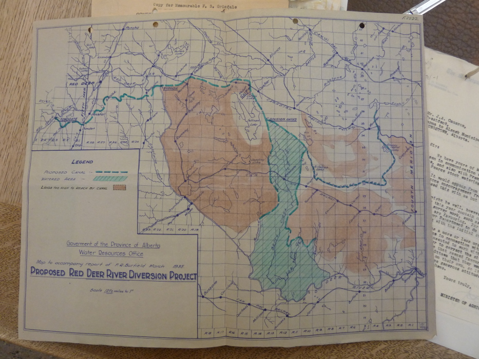 |
|
Figure 2: The 1935 Red Deer Diversion Project Map (Government of the Province of Alberta Water Resources Office. 1935) |
In 1935, it was proposed that the irrigation project would divert the Red Deer River downstream of the Town of Sundre above what is now Glennifer Lake by a diversion channel that would be fed from a constructed earthen dam (see Figure 2 and Map 1). A reservoir would also be constructed somewhere in the headwaters on the Red Deer River that would hold a storage capacity of 406,698 cubic decametres (dam3) in order to successfully feed the irrigation project. The exact location of this reservoir was not clearly outlined in the historical records. Other storage sites were also mentioned as part of this irrigation project. These were reservoirs located in the headwaters of the Clearwater and North Saskatchewan Rivers (see Map 1), reported to store a total of 712 645 dam3 (Jacobson, W.L. 1920-1960).
From the Red Deer River the water would be carried by a large diversion channel to Sullivan Lake. It was thought that Sullivan Lake would be an excellent site to store large quantities of water as it had an approximate storage capacity of 2,405,744 dam3. From Sullivan Lake the water would be diverted easterly into Sounding Creek and carried through 321 km of the natural creek beds of Sounding and Eyehill Creeks and then on to the Rosetown and Saskatoon Irrigable tracts, which contained some 2,990 km2 irrigable lands. The water would also be diverted southeasterly from Sullivan Lake, and distributed to such streams as Bull Pond, Berry, East Berry, Blood Indian and Alkali Creeks as well as the many coulees throughout that area. Distributing water over Sullivan Lake, Berry Creek, Monitor, Acadia Valley, Kindersley and the Elrose would provide irrigation to 2,719 km2 of irrigable lands making the total irrigable area under the 1935 proposed project 5710 km2. For a detailed outline of this project see Map 1 (Jacobson, W.L. 1920-1960).
In order to divert a sufficient quantity of water, reservoirs would need to be built in the headwaters. A number of storage sites were surveyed during the inception of the North Saskatchewan Irrigation Projection. The exact location and storage capacity of these surveyed storage sites, Dam 1, Dam 2, Dam 3, Dam T, Dam 4-A, Dam 5, Dam 6 and Dam 8 were not found in the records. However, WaterSMART identified the locations of these sites (see Map 1) based on a map that was published in 1935 by the Government of Alberta Water Resources Office (see Figure 2) (Jacobson, W.L. 1920-1960).
The 1945 North Saskatchewan Irrigation Project
In 1945 the PFRA reviewed the original North Saskatchewan Irrigation project that was proposed in 1935 and a new map was conceptualized for the project. The 1945 scheme expanded the irrigation project to Saskatchewan expanding the irrigable lands from 5710 km2 to 76,890 km2.
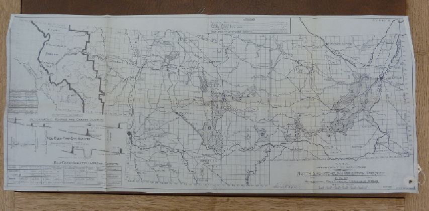 |
| Figure 3: The 1945 North Saskatchewan Irrigation Project Map
(Prairie Farmers Rehabilitation Association. Department of Agriculture. 1945) |
The 1945 irrigation scheme, seen in Figure 3, was based on tapping the North Saskatchewan River in the vicinity of Rocky Mountain House. The water would flow through the drainage of the Red Deer River and the Clearwater River, and then through various drainage courses into Buffalo Lake. Buffalo Lake would be raised more than twenty feet to create a reservoir. From there the canal would extend easterly by way of Stettler, Halkirk, and Lanes Lake and then around the east side of Sullivan Lake where the gravity-fed distribution system would begin. A system of canals, natural water courses, reservoirs and other facilities would distribute water throughout the portion of the drought-prone area. For a detailed outline of the project see Map 1 (Jacobson, W.L. 1920-1960).
A dam would need to be constructed in order to supply water to feed this irrigation scheme. The proposed location of a potential dam was across the Red Deer River near the Content Bridge, west of Stettler and 64 km east of City of Red Deer (see Map 1). The canal would then take the water 128 km northeast to Buffalo Lake. The main irrigation canal would be gravity-fed and run south-easterly of Buffalo Lake. No storage volumes of the dam at Content Bridge were recorded (Jacobson, W.L. 1920-1960).
Historical Flood Mitigation Solutions on the Red Deer River
In the 1970s, Alberta Environment’s Planning Division conducted a series of studies to determine flood mitigation options on the Red Deer River. Ideas put forward were designed to mitigate flows for a probability measure of one percent chance of flooding. The studies found only two communities – Sundre and Drumheller – in the Red Deer River Basin that could be at risk from flooding. Concepts for flood mitigation for Sundre and Drumheller are discussed below (AEPD, 1975).
Sundre
Sundre is threatened by flooding from two sources: overbank flows from the Red Deer River, and a combination of overbank flows from the Bearberry Creek and overland flows from the Bearberry Prairie, southwest of town (AEPD, 1975). It was reported that the two conditions are quite separate and seldom occurred simultaneously (AECA, 1977).
Potential Dam Sites for Flood Mitigation on the Red Deer River Upstream of Sundre
In the 1970s the GoA commissioned a number of reports to identify potential dam sites upstream of Sundre on the Red Deer River. The 1970 report commissioned by the GoA identified twenty potential dam sites on the Red Deer River. In 1973 the sites were reviewed to determine their feasibility. The 1973 study determined that of the twenty potential dam sites only six storage sites met flow augmentation of 16 cubic metres per second (cms) and the flood control requirements for Sundre, Alberta (AEPD,1976). The five sites were dam Site 9, 11, 12, Williams Creek, and Logan Creek in combination with Dam Site 18 or 19 and can been seen on Map 1. The six storage options identified are discussed below in Table 1.
Table 1 : The Six Storage Options for Flood Mitigation Upstream of Sundre
| Concept | Description |
| Dam Site 9 |
|
| Dam Site 11 |
|
| Dam Site 12 |
|
| Williams Creek Dam Site |
|
| Logan Creek Dam Site In Combination with Dam Site 18 or 19 |
|
None of the six sites was ever constructed.
A further review of flood mitigation options in 1977 referenced the above storage sites. The 1977 report determined if a dam was constructed upstream of Sundre it would alleviate most of the flooding from the Red Deer River (AECA, 1977). Dam Site 11 and Williams Creek Dam Site were thought to offer the best potential for such a structure. Both Dam Site 11 and Williams Creek Dam Site would need to be constructed in conjunction with a system of dykes up to 2 metres in height with a width of 3 – 8 metres to ensure greater protection to Sundre in the event of a flood from the Red Deer River (AEPD, 1975).
Flood Mitigation from Bearberry Creek
For flooding issues associated with the Bearberry Creek and Bearberry Prairie, proposed flood mitigation solutions were in the form of a 4 km dyke along the south bank of Bearberry Creek and two proposed diversions. One was the restoration of an existing Bearberry Creek Diversion constructed in 1956. The other was a new concept to develop a channel that would divert flows from Bearberry Creek and Bearberry Prairie to the Red Deer River (AEPD, 1975). These two diversions are discussed below.
1956 Bearberry Creek Diversion
In 1956 Bearberry Creek was diverted at a point about 1.6 kilometres above its confluence with the Red Deer River. This diversion was constructed to provide flood protection to the town of Sundre. The diversion flowed through the center of Sundre where it rejoined the Red Deer River (see Map 2). In 1975 this diversion was still in use but was only partially effective for flood management. In 1975, the Alberta Environment and Planning Division (AEPD) proposed that this diversion system had the potential to be upgraded to handle greater flood flow volumes (AEPD, 1975). The 1956 Bearberry Creek Diversion is still in use today (see Map 2). There is no evidence that suggests that it was ever upgraded to handle greater flood flow volumes.
Proposed Bearberry Creek Diversion
The channel identified on Map 2 was planned to depart from the creek at a point about 2.7 km west of the confluence of Bearberry Creek and the Red Deer River. The water would then run south-easterly across Bearberry Prairie to a point on the Red Deer River about 1.6 km upstream from the highway bridge. The channel would coincide with the Bearberry Creek bed at the inlet and with the bed of high water flood channel of the Red Deer River at the outlet. The gradient of the channel would be about 0.27 percent which coincides with a regime slope for 84 (m3/s) that is only mildly erosive. It was believed that this was as steep as an unprotected channel should be made from the gravel materials present. The proposed diversion was thought to coincide reasonably well with the low flow gradient of the main river, allowing for meanders and rapids. A limited volume of rip rap was required at the outlet of the diversion to provide protection against erosion damage from flows in the Red Deer River floodway. The proposed diversion would pass through numerous farm operations along the route which contained about 50% cultivated and 50% pasture land. In 1976, the estimated cost of building this proposed diversion was $354 thousand dollars, or about $1.4 million dollars today (Klohn et al. 1976).
Drumheller
Drumheller is exposed to flooding because of its extensive occupation of floodplain lands. Recognition of this problem has led to the development of zoning schemes which forbid construction on such lands (AECA, 1977).
Historically, flooding in the Drumheller area dates back to the early 1900s with the largest flood on record occurring in 1915. This flood caused extensive damage to the neighbourhoods of Midlandvale and New Castle (AEPD, 1975).
To protect all communities from a one percent chance of flood flow volumes an extensive system of protective dykes would need to be constructed. In total 11 dykes would need to be built through the community of Drumheller (see Map 3) ranging from 27 to 3,169 metres in length and 4 metres in height (AEPD, 1975). Construction of dykes to protect against a one percent chance of flooding would require the relocation of some existing buildings. In addition, due to their sheer magnitude, the dykes would give an unattractive appearance to the town. In the 1970s, the estimated cost of the dykes was around $4 million. Compared to the estimated damage from a one percent chance of flooding, at the time being around $5.8 million, resulted in the assessment that building a system of dykes to protect against a 100 year flood would not be in the public interest, and therefore, consideration would be given to a system of dykes built to protect against lesser flood flows. It was felt that better zoning restrictions for development in the floodplain would be a better solution for Drumheller’s flood problems (AECA, 1977).
A report, published in 1977, by Klohn Leonoff Consultants, for the AEDP, determined that in order to reduce flows through the Drumheller area by approximately 369 m3/s head water storage would be required upstream on the Red Deer River. This reduction in flood flows would also require a series of dykes throughout various Drumheller communities, which could be built to a lesser requirement than the one percent probability of flood flow volumes (Klohn et al. 1977).
Alternative Solutions for Flood Mitigation on the Red Deer River
A study conducted in 1977 by the Alberta Environment Conservation Authority (AECA) found that floods had been occurring along the Red Deer River Basin long before human settlement. The review of measured flows of the Red Deer River indicated that the wide fluctuations in flow levels were mainly caused by climatic conditions. This led to the conclusion that that the magnitude of some floods has increased over the years due to basin changes brought about by man. The study also found that lands that were cleared of their vegetation were found to have a higher runoff rate and held less water (AECA, 1977).
Restoration of Floodplains
The study determined that it would be prudent to develop and apply ecological restoration programs that could decrease the magnitude of flooding events. It was thought that the implementation of programs that restored the vegetative capacity of the floodplains would lessen some of the flood flow impact, particularly in the vicinity of drainage courses which are a part of the total river system. Many of the natural storage reservoirs in the form of wetlands such as sloughs and muskegs had been drained at the time of the study, which resulted in water being delivered more quickly to the Red Deer River system. The study concluded that good watershed management practices that maintain and protect these natural storage systems throughout the basin were effective flood mitigation solutions. The findings of this study were as follows:
- Changes in land use are a contributing factor to increased flooding.
- Temporary water storage systems that have existed naturally have been eliminated, exacerbating the impacts of flooding.
- Wetlands must be maintained as a method of flood reduction.
- The Water Resources Act regarding the drainage of wetlands must be more effective and enforced.
- There are many different methods and combinations of methods to solve or at least abate the problems of flooding (AECA, 1977).
Agricultural Flooding
The 1977 study determined that the farmlands most vulnerable to flooding are the low lying benches of the river valley. It was recommended that farmers and vegetable growers recognize the associated risk of planting in the low lying bench lands (AECA, 1977).
Urban Flooding
As mentioned earlier, Sundre and Drumheller are the communities most impacted by flood flow volumes from the Red Deer River. Due to the fact that in both locations a dam alone would not provide complete protection it was felt that greater emphasis should be placed on zoning regulations which forbid urban development of floodplains. It was recommended that a comprehensive inventory be made identifying the flood-prone areas within the settled regions of the Red Deer River Basin (AECA, 1977).
Associated Risk
It was recommended that the GoA investigate the feasibility of establishing some form of compulsory flood insurance to apply to new buildings constructed in developed flood plain areas. It was thought that some people may be given permission to build in the floodplain when the frequency of flood is 1 in 100 years or even 1 in 50 years on the condition that they take out flood insurance. Under this plan, the person building in the floodplain would be aware of the risk associated and assume part of the cost of this risk. This procedure would allow development of some lands now withheld due to danger of floods. In case of flood damage the government would pay a portion of the damage that is not covered by the insurance policy (AECA, 1977).
Summary of Findings
Table 2 below outlines the irrigation schemes, water storage sites and diversion canals that were discovered during this historical review.
Table 2: Historical Irrigation Schemes, Water Storage Sites and Diversion Canal Findings
| Historical Concept | Year Conceptualized | Storage Capacity (dam3) | Estimated Flow Diversion (m3/s) | Irrigable Acres (km2) | Comments |
| Canyon Creek Site | 1916 | – | – | – | Hydroelectric Power Development |
| Red Deer Diversion Project Proposed Dam / Irrigation Project | 1935 | 406,698 | – | 5,710 | Drought Mitigation |
| North Saskatchewan Irrigation Project | 1945 | – | – | 76,890 | Drought Mitigation |
| Dam Site 9 | 1970 | 277,500 | – | – | Flood Mitigation |
| Dam Site 11 | 1970 | 289,900 | – | – | Flood Mitigation |
| Dam Site 12 | 1970 | 289,900 | – | – | Flood Mitigation |
| William Creek | 1970 | 277,500 | – | – | Flood Mitigation |
| Logan Creek Combination Site | 1970 | 277,500 | – | – | Flood Mitigation |
| 1956 Bearberry Creek Diversion | 1956 | – | – | – | Flood Mitigation |
| Proposed Bearberry Creek Diversion | 1976 | – | 84 | – | Flood Mitigation |
| System of Dykes in Drumheller | 1977 | – | – | – | Flood Mitigation |
| Dam in the headwaters with system of Dykes in Drumheller | 1977 | – | 369 | – | Flood Mitigation |
The detention site mentioned by the Department of Interior in 1919 for hydroelectric power was never estimated for storage capacity and its exact location was not indicated.
The North Saskatchewan Irrigation Project was designed to mitigate for drought and would irrigate 5710 km2 area of land. The project would require the storage of 406,698 dam3 on the Red Deer River. Originally conceptualized in the 1920s, the PFRA revisited this irrigation scheme in the 1930s and 1940s. The project was thought to be feasible and cost effective ensuring a water supply to drought affected areas of the Red Deer Basin.
The review of the historical records for the Red Deer River watershed determined that there are two communities that are vulnerable to flooding: Sundre and Drumheller.
A number of storage sites were proposed to alleviate flood flows from the Red Deer River at Sundre Dam Site 9, 11, 12, Williams Creek and Logan Creek. None of the detention sites identified to mitigate for the flooding at Sundre were ever constructed. Most of the proposed detention sites identified were found to be detrimental to local fish and wildlife populations. Two diversion projects were proposed to mitigate for the flood flows of Bearberry Creek and Prairie; one in the form of upgrading the existing 1956 Bearberry Creek Diversion and the other in the form of a newly constructed bypass channel.
For the community of Drumheller an extensive system of large dykes was proposed to protect the town from flood events. However, the cost of the dyke system along with their unattractive appearance made them an unpopular flood mitigation option.
Better watershed management was proposed as another mitigation solution for flooding events. This was to be implemented through the restoration of wetlands and woodlands throughout the Red Deer River basin.
Better zoning restrictions were also proposed as a flood mitigation option along with some form of overland flood insurance for those wishing to build in the floodway.
Conclusion
In conclusion, it is important to be aware of historically proposed mitigation solutions for floods and periods of drought in order understand where we have come from, how we have historically viewed and developed our watersheds, and how these past proposals could apply to our present mitigation situation. In reviewing past flood and drought mitigation strategies from historical maps, reports and investigations this study identified a number of potential options. The options discovered were in the form of irrigation schemes, hydroelectric power development, water storage sites and diversion channels on the Red Deer River. These historically proposed mitigation strategies should be taken into account when looking to mitigate for future floods and periods of drought within the Red Deer River watershed.
References
[1] Alberta Environment Planning Division. 1976. Red Deer River Basin Preliminary Planning Report on Potential Damsite Upstream From Sundre
[2] Alberta Environment Planning Division.1975. An Assessment of Alternatives to a Dam on the Red Deer River
[3] Alberta Environment Conservation Authority. 1977. Flow Regulation of the Red Deer River Report and Recommendations
[4] Department of Interior Topographical Surveys. 1916. Vol. LI no. 19. Sessional Papers
[5] Government of the Province of Alberta Water Resources Office. 1935. Proposed Red Deer Diversion Project
[6] Jacobson, W.L. 1920-1960. Fonds File 413. William Pearce Red Deer River Project 1921-1960. Retrieved from the Glenbow Museum and Archives
[7] Klohn Leonoff Consultants LTD. For the Environment Planning Division Alberta Environment. 1976. Feasibility Study Flood Protection Sundre and Drumheller Red Deer River
[8] Klohn Leonoff Consultants LTD. For the Environment Planning Division Alberta Environment. 1977. Flood Protection in Drumheller Valley Dam At Site 6 Red Deer River
[9] Prairie Farmers Rehabilitation Association. Department of Agriculture. 1945. Map of the North Saskatchewan Irrigation Project