Historical and Future Glacier Retreat
In this section, we analyze glacier changes during the historical period (the last four decades) and projected future changes in the glacierized area, glacier mass balance, and meltwater runoff from glaciers in the Rockies.
 Changes in Glacierized Area

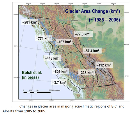
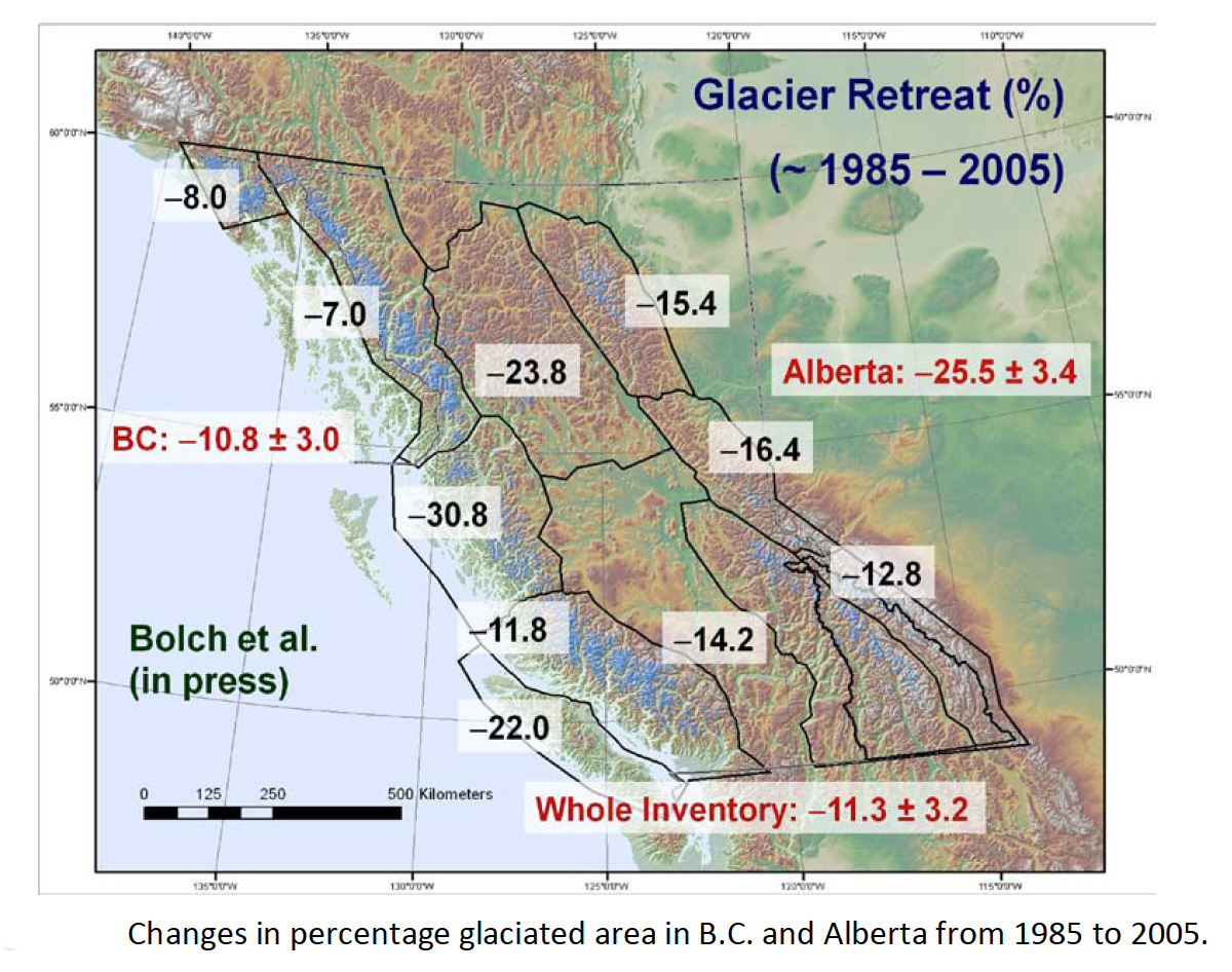
The diagrams illustrate the B.C. and Alberta-wide changes in glacier area for the 20 year period (1985 to 2005), subdivided into major glacier-climate zones.
The southern, central, and northern Rockies in these plots include both eastern and western slopes. These regions experienced a loss in ice cover of about 15% from 1985 to 2005. When Alberta glaciers are isolated, one sees a 25% decrease in glacier area over this period, from 1,053 km2 to 786 km2.
All regions in B.C. and Alberta are experiencing glacier loss. The greatest total losses occurred in the most heavily glaciated regions, as one would expect.
The eastern slopes of the Rockies experienced disproportionately heavy losses: 25% of the total glaciated area (vs. 11% for B.C). The reason for this contrast is not well-understood, but probably arises from two main factors:
- The predominance of relatively small glaciers in Alberta
- More significant reductions in snowfall in the eastern slope of the Rockies over this period, relative to coastal and interior B.C.
The average glacier size in Alberta (2005) is 1.14 km2. By contrast, the average glacier size in B.C. (2005) is approximately 2.11 km2. Small glaciers are known to be more sensitive to climate warming, due to a variety of the positive feedbacks associated with sustained negative mass balance (loss of the firn layer, darkening of the glacier surface, increased sensible heat flux to the glacier from the surrounding, freshly-deglaciated rock).
Because glaciated area is an important aspect of glacier contributions to streamflow, this rapid loss of glacier ice is evident in reduced late-summer streamflows in Alberta’s rivers. Glaciers are losing mass, supplementing streamflow, but they are playing a diminishing role in water resources in Alberta.
Glacier mass balance data has been gathered from approximately 310 glaciers worldwide over the past several decades, although only a subset of sites has longterm data. This data is archived through the World Glacier Monitoring Service. The observations document worldwide glacier retreat in recent decades, similar to what is observed in the Rockies.
Download
Alberta Glacier Inventory and Ice Volume Estimation (3.49 MB)