Request for Feedback: McLean Creek Benefit Cost Analysis and Environmental Review
The following is a summary of the IBI report “Benefit/Cost Analysis of Flood Mitigation Projects for the City of Calgary: McLean Creek Flood Storage” and the AMEC report “Environmental Overview of the Conceptual Elbow River Dam at McLean Creek”. Please read both reports for a full understanding of the Benefit/Cost Analysis and Environmental Review for this mitigation project. Given the simultaneous release of these reports the McLean Creek Environmental Review has highlighted new items of concern that would require additional costs, and are therefore not reflected in the IBI study.
The McLean Creek Dam will consist of:
- an earth fill dam built across the main stem of the Elbow River,
- a combined permanent outlet/spillways structure for discharging normal and flood flows and
- an auxiliary earth cut channel spillway to protect the dam from extreme floods up to the probable maximum flood event.
Damage Assessment
Project Costs
The IBI reports restates that the cost of the McLean Creek dam designed to accommodate a 1:100 year flood event is estimated to be $239,581,000 based on 2012 construction price data. Similarly to the Springbank Off-Stream Reservoir project these numbers are based on preliminary engineering design provided by the AMEC 2014 study. Additional subsurface soils investigations and more detailed hydrological assessment and topographic data are required to better establish concept details and size. The IBI analysis includes a 25% contingency as an attempt to account for additional costs that may be incurred as a result of further development of the engineering design.
If the McLean Creek Dam was designed to protect for the 2013 flood the size of the structure would increase. The AMEC 2014 study states that the result of these changes would add approximately $55 million to the project costs.
The proposed project is located within the Green Zone and is located on Crown Land. The reservoir will inundate a portion of the existing Kananaskis Highway 66 including a bridge crossing the Elbow River, the highway and bridge will need to be relocated. The following recreational areas would also need to be relocated, altered, or dismantled: Paddy’s Flat recreational area, River Cove group camp facility, Allen Bill Pond, Station Flats, Elbow Ranger Station.
The McLean Creek Cost Benefit analysis reports that the cost of replicating these facilities within the general area and on Crown Land is between $40 and $50 million. Additionally the report estimates that the environmental impact assessment studies required to evaluate the project would cost $4 million.
Flood Damage Reduction
According to the IBI analysis, the implementation of the McLean Creek dam results in a reduction of average annual damages of the following:
- 1:100 year level of protection under the higher damage scenario: $19,461,291
- 1: 200 year level of protection under the higher damage scenario: $26,114,777
- 1:100 year level of protection under the lower damage scenario: $13,746,068
- 1: 200 year level of protection under the lower damage scenario: $16,686,439
Benefit/Cost Analysis
The figure below highlights the key results of the benefit / costs analysis of the McLean Creek dam. It should be noted that this analysis was conducted solely based on economic costs and does not take social costs, or environmental impact into account.
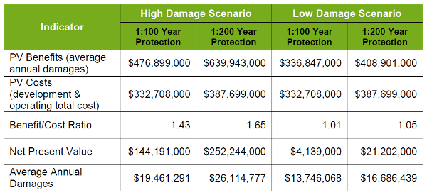
The McLean Creek dam achieves a positive benefit/cost ration under all four scenarios, indicating that it is an economically effective project. However in the two low damage scenarios it is only marginally economically effective. As noted above, this analysis is based on a preliminary engineering design, and the numbers will very likely shift around as more detailed work is completed.
Environmental Review
The environmental overview of the McLean Creek Dam Project summarized the environmental resources and associated land uses that could be affected if the Project were to be developed. It looked at environmental and social issues that may arise, data gaps, and options to mitigate identified issues. The report did not identify anything that would immediately rule out continued work on the project, although additional issues were noted.
Environmental Overview
Some of the issues and mitigation measures from the report have been outlined below. Please read the full report to understand the full extent of the identified issues, data gaps, and mitigation measures.
| Topic | Issues | Mitigation |
| Hydrogeology | During excavation of the project short-term groundwater seepage control and management issues may arise.There may be long-term impacts to well owners/operators downstream of the project. | An additional study of the area’s groundwater to understand its impacts. Monitoring private water wells and offering compensation for impacts. |
| Surface Water Quality | Potential water impacts could include water temperature and dissolved oxygen, total suspended solids (TSS), nutrients (nitrogen and phosphorus) and microbiology (Total and fecal coliforms), and impacts to groundwater chemistry. | The operating regime for the project will influence the extent and severity of surface water quality issues. The operating regime would have to be determined because it has a direct influence on the potential environmental effects that could arise from the Project. |
| Fisheries and Aquatic Resources | Fish habitat alteration or loss, and disruption of fish migration and passage. One “Threatened” species, the bull trout, were found in the area. |
Altering the design to include fish passage |
| Soils and Terrain | Potential impacts to the soils include erosion, admixing, rutting, compaction and an increased stoniness. | Creation of an erosion and sediment control (ESC) plan. |
| Vegetation | Upstream of the dam there is possibility for a loss of ecological land classes due to clearing of the area and water impoundment. Downstream of the dam changes in the water table may change ecosites. |
Clearing vegetation prior to reservoir filling, and using best management practices. |
| Wildlife | Project facilities could create a barrier to movement for animals, such as grizzly bear, alter movement patterns, and result in changes in habitat availability. Four “Sensitive” species have historically been found in the area. They are the bobcat, Canada Lynx, harlequin duck and northern pygmy-owl. |
Best management practices, such as restricted activity periods and posted road speeds, would be typical mitigation measures. Additional wildlife information is required for the Environmental Impact Assessment. |
| Historical Resources | A field visit identified an archaeological site within the reservoir footprint. It’s possible there are additional archaeological sites. | A separate palaeontological Historical Resources Impact Assessment (HRIA) would like be required. ACT |
| Land Use | The area is currently used for a wide variety of purposes – recreation, forestry, and infrastructure. Developing the Project would affect these uses and may preclude several of them from occurring in the Project footprint. | Compensation for RFMA holders in accordance with the Alberta Trappers Compensation Board guidelines as is necessary. Ongoing communication with stakeholders and community. Moving or altering or some recreational sites. |
Request for feedback
What are your thoughts on the McLean Creek Dam project Benefit/Cost study and the McLean Creek Environmental Review?
Please contact the Alberta WaterPortal by email, or through the comments below. Feedback is accepted until March 31st. All feedback will be summarized and provided back on the WaterPortal and to the Government of Alberta.