Rising Up: Understanding Groundwater Flooding and Associated Risks
During the June 2013 flood, the front pages of newspapers and websites across Alberta and Canada displayed images of overland flooding. In the months following however, news coverage began to focus on a different contributor: groundwater. Flooded basements, sewer back-ups, out of service elevators, cracked foundations, water mysteriously appearing behind berms; these were all symptoms of groundwater flooding. Simply put, groundwater flooding can cause at least as much damage as overland flooding; a fact that has often been overlooked and under-recognized.
What is going on underground?
There are a number of ways in which groundwater can contribute to flood damage:
Seepage: In the case of groundwater seepage, a build-up of water in the ground causes the underground water table to rise to the level of subsurface structures (e.g. basements, garages and underground parkades). Water then seeps into the structures through cracks and other structural faults;
Sewage back-up: In the case of sewage back-up, water on flooded streets drains into manholes, causing an overload of the sanitary sewer system. This can force sewage water back through the sewer line and into basements;
The above contributors to flooding can occur individually or simultaneously, and may be further exacerbated by overland flooding.
Since it is commonly believed that the easiest way for water to enter buildings from the subsurface is through the sewer system, basement flooding has often been blamed on sewage back-up when, in fact, the culprit may be groundwater. Understanding the role that the groundwater environment plays during flooding events is of the utmost importance in terms of identifying areas at risk.
Where is there a risk?
The current flood hazard maps were designed to illustrate risk of overland flow, not the risk of groundwater flooding. There were several communities (e.g the Siksika Nation) that were flooded in June 2013 due to groundwater, but these communities were not identified on the provincial flood maps as being at risk of flooding[1].
One of the greatest challenges for Alberta’s decision makers, who are tasked with creating long-term water management plans and mitigation strategies, is the fact that that they are making decisions with an incomplete understanding of the water system. If proactive and informed decisions are to be made that properly identify all areas of flood risk, areas that are susceptible to groundwater flooding need to be identified. Identifying and mapping areas susceptible to groundwater flooding is the first step in understanding the role that the groundwater environment plays during flooding events.
The Risk of Not Knowing
To date, the majority of proposed mitigation strategies and management plans have been heavily focused on controlling surface water sources; however mitigation strategies and management solutions which only take into account overland flow may solve only part of the flooding issues. The greatest risk of not understanding the groundwater dynamic during flooding events is the possibility of triggering unintended consequences of mitigation and management strategies. A typical example of a mitigation strategy is the construction of berms along river channels that are intended to protect existing infrastructure by preventing river levels from spilling over their banks. However, as shown in Figure 1, increases in the river level could cause water to flow through the subsurface and circumvent these engineered mitigation strategies and continue to flood the allegedly protected infrastructure.
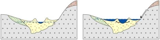
Figure 1: Schematic river valley cross-section showing a river (blue fill) and groundwater level (dashed line) under normal conditions (left) and flood conditions (right)[2].
What do we need to know?
In Alberta, the first step is to gain a better understanding of the geology and key groundwater sources (aquifers) that cause groundwater flooding. Focus should be put on the alluvial aquifers and paleo-channels that line the river valleys.
| Alluvial Aquifer | An alluvial aquifer consists of unconsolidated sand and gravels that were deposited by a river or stream. |
| Paleo-channel | A paleo-channel is a remnant of an inactive river or stream channel that has been filled or buried by younger sediments. A paleo-channel consists of sand and gravels that are the same size of those which make up the current channel. |
Alluvial aquifers and paleo-channels are typically hydraulically connected to one another. Homes built on the alluvial aquifer (e.g. the community of Sunnyside in Calgary) or those built on a paleo-channel will be at a higher risk to groundwater flooding as flood waters can enter these systems quickly. These systems need to be properly mapped and the areas of risk identified.
The second step is gain a better understanding of how the groundwater and surface water environments interact with each other. How do changes in river stages (i.e. river flow and height) affect the groundwater environment and how quick does groundwater respond to these changes? Does groundwater discharge into rivers and streams play a significant role in the manifestation of flooding events? The answer to these questions can ultimately equate a river stage to changes in groundwater levels. This will help identify areas at risk to groundwater flooding as well as the circumstances under which flooding may occur. For example, groundwater flood maps could be created which show what the water table would look like during a 1 in 100 year flood event and who might be affected by this rise in groundwater.
Groundwater flood mapping is not a new concept. Flooding legislation recently introduced in Europe and transposed into law in the United Kingdom has recognised the importance of groundwater flooding by incorporating a requirement to assess the risk and undertake measures to reduce this risk where groundwater flooding is significant. The United Kingdom – through the British Geological Survey – has done extensive work in terms of groundwater flood mapping and risk assessment in Southern England. Reaching out to other jurisdictions that have completed or a currently in the process of going through groundwater flood mapping exercises, could help Alberta develop a solution to this complex issue.
Ryan Bjornsen is a Hydrogeologist at Alberta WaterSMART
[1] Ryan, Cathy. (2014, March). The (under-recognized) role of groundwater in flooding). Paper presented at CWRA (Canadian Water Resources Association) Alberta Branch Conference, Calgary, AB.
[2] British Geological Survey, 2013. Flooding in a Shallow Unconsolidated Sedimentary Aquifer Setting. <accessed on-line December 2013 at http://www.bgs.ac.uk/research/groundwater/flooding/unconsolidated.html>