Bow River Water Quality Monitoring: It’s Happening on Your River by Cecilia Chung
Today’s blog post first appeared in the Bow River Basin Council’s publication ‘ Preserving Our Lifeline‘. You can read past newsletters and editions of ‘Preserving Our Lifeline’ here.
Alberta Environment and Sustainable Resource Development (ESRD) has been providing province-wide water quality monitoring in Alberta since its inception in the 1970s. This 2-part series introduces the current water quality monitoring program in the Bow River Basin. Part 1 (in the September 2014 issue) discussed long-term, annual projects; here, Part 2 presents a few other shorter-termed projects and ongoing studies.
In addition to long-term, annual projects such as long-term river network monitoring, macrophyte sampling and lakes and reservoirs monitoring, ESRD is also involved in a number of other monitoring initiatives in the Bow River Basin. Many of these projects are in support of Watershed Planning and Advisory Councils (WPACs), providing important monitoring data to guide planning and decision making. The 2014-2015 monitoring season included additional monitoring in the Sheep River, Highwood River and lower tributaries of the Bow River.
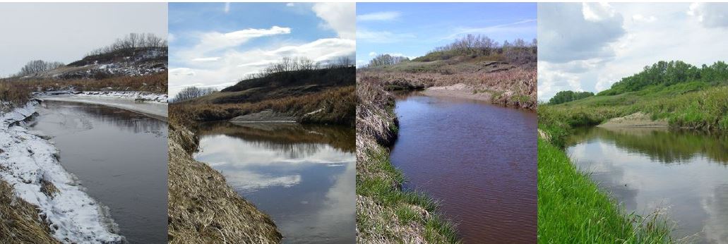 |
| West Arrowwood Creek in the Crowfoot Creek sub-basin; photos taken monthly from March to June, 2014. Photo: Alberta Environment and Sustainable Resource Development |
In the past year, there substantial progress has been made on the modelling of the Bow River. A significant portion of this work was done in support of the Bow River Phosphorus Management Plan, which was published in April 2014. The need for more data to guide phosphorus management has spurred additional monitoring in the lower tributaries of the Bow River, with a focus on Crowfoot Creek, and East and West Arrowwood creeks. Crowfoot Creek is the main tributary to the Bow River within the Crowfoot Creek sub-basin; the Arrowwood creeks also contribute substantial flows, particularly from March to April. This area experiences intense agricultural activity, which may subsequently impact surface water quality in the streams through nutrient, bacterial and pesticide inputs. Information gathered from this monitoring will help not only to refine our models by providing more accurate estimations of tributary inputs into the Bow River, but also to observe the degree of land-use impact on surface water quality.
Threepoint Creek flows into the Sheep River, which then flows into the Highwood River. As the Highwood River is a major tributary of the Bow River, monitoring all three streams helps us to evaluate the health of each stream as well as what is entering the Bow River at the mouth of the Highwood. In the wake of the 2013 southern Alberta flood, there is increasing work on flood-related projects around the Bow River Basin, especially around the Highwood and Bow rivers. Amassing this monitoring data will help to provide baseline information for upcoming projects and better evaluate associated implications for water quality.
To lessen anthropogenic pressure on the Highwood River, the Town of High River and Cargill Ltd. discharge their treated effluent into Frank Lake rather than into the Highwood River. Frank Lake is a restored wetland managed by Ducks Unlimited Canada, located east of High River. Although not situated in the Bow River Basin, the use of Frank Lake decreases the amount of tributary input into the Bow River, helping to maintain the health of the Bow. A dye study was performed in Frank Lake in September 2014, in support of existing modelling work and management of the lake. The objective of the dye study was to improve understanding of basin circulation, such that we are able to better evaluate the performance and effectiveness of the lake. Results will be made available in early 2015.
ESRD also undertook a major project in mid-August 2014: a synoptic survey for the Alberta portion of the South Saskatchewan River Basin. The survey aimed to identify point source loadings (with tributaries also acting as point sources) at low flow conditions, and comprised tracking a parcel of water from the headwaters of the Red Deer, the Bow and the Oldman rivers as it travels downstream and joins into the South Saskatchewan River. The Alberta Environmental Monitoring, Evaluation and Reporting Agency (AEMERA) team sampled at 130 sites over two weeks, around the clock, following a strict sampling schedule dictated by time-of-travel calculations. Wastewater treatment plants in the basin assisted in procuring effluent samples, which provides important context for our in-stream water samples. While the field portion is completed, work continues on the organization and evaluation of the collected data. Results from the 2014 South Saskatchewan River Basin Synoptic Study will be reported in the upcoming year.
Surface waters in our province are a valuable resource and require careful management, especially in a basin such as the Bow, where there is substantial urban development in addition to agricultural land use. Monitoring is an integral step in our understanding of Alberta surface waters, in order that appropriate decisions can be made regarding the use of these systems. Any information gathered from surface water quality monitoring is freely available to the public, and can be found at http://esrd.alberta.ca/water/reports-data/surface-water-quality-data/default.aspx.
Cecilia Chung is a Water Quality Specialist with Alberta Environment and Sustainable Resource Development. For more information, contact Cecilia Chung (Limnologist, ESRD) at cecilia.chung[at]gov.ab.ca or Wendell Koning (Limnologist, ESRD) at wendell.koning[at]gov.ab.ca.